1821 Otto von Kotzebue Map of the Marshall Islands
MarshallIslands-kotzebue-1821$950.00

Title
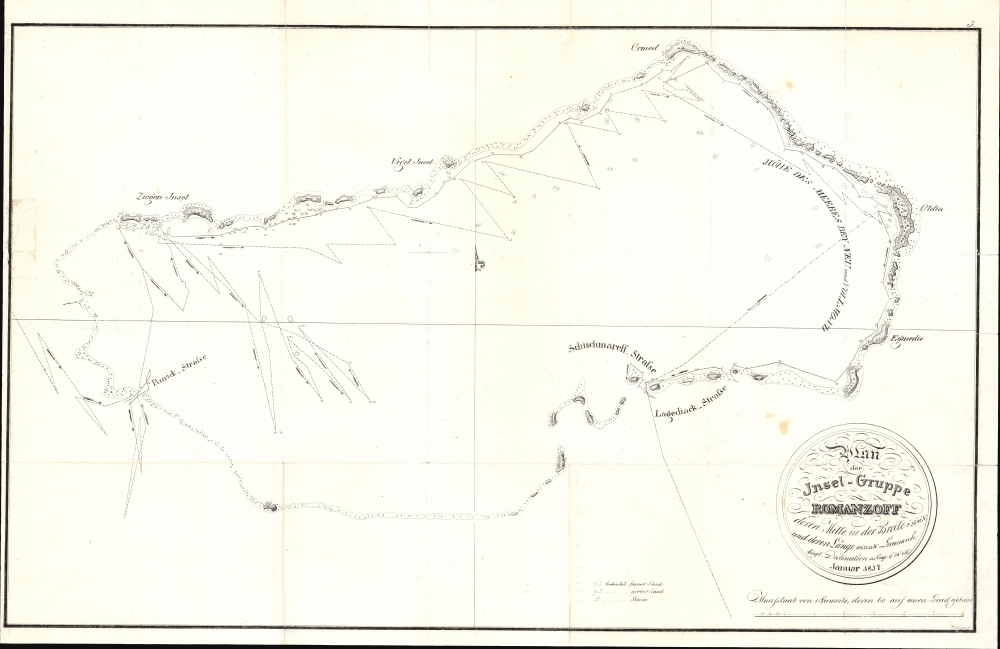
Plan der Insel-Gruppe Romanzoff...
1821 (undated) 16.75 x 26.75 in (42.545 x 67.945 cm) 1 : 4300
1821 (undated) 16.75 x 26.75 in (42.545 x 67.945 cm) 1 : 4300
Description
This is Otto von Kotzebue's 1821 map of the Marshall Islands, considered the first specific map of that archipelago. Kotzebue named them the Romanzoff Islands, but this part of the Marshalls is today known as the Ailinglaplap Atoll. The map resulted from Kotzebue's Rurik Expedition, the second Russian circumnavigation of the globe.
Setting out from Kronstadt in late July 1815 with a small crew aboard the Rurik, Kotzebue was accompanied by fellow ethnic Germans, naturalists Johann Friedrich von Eschscholtz and Adelbert von Chamisso, and the artist Louis Choris. Sailing first to the Cape of Good Hope, by the spring of 1816 the expedition ventured into the Pacific, where its most extensive and important discoveries were made. Dozens of islands and atolls in the current Cook Islands, Marshall Islands, and French Polynesia were visited, some of which had been visited by Cook or earlier explorers, others which were entirely new discoveries. After leaving Polynesia, Kotzebue sailed north to Petropavlovsk on the Kamchatka Peninsula (reaching it on June 18, 1816). Afterward, his expedition sailed east to the Bering Strait and Alaska, then headed south to California, the Sandwich Islands, and returning to the South Pacific before beginning the long return voyage through Southeast Asia, the Indian Ocean, around Africa, and back to St. Petersburg.
In 1823 - 1826, Kotzebue led a second expedition that expanded upon his earlier Pacific discoveries. Though not as well known as the preceding generation of European explorers of the South Pacific, namely Cook, Kotzebue nevertheless added considerably to the cartography of the Pacific.
A Closer Look
This chart traces the course of the Rurik through the Ailinglaplap Atoll of the Ralik Chain in the Marshall Islands in 1817. The islands, along with interconnecting rocks, form nearly a complete circuit. Soundings are noted along the course of the Rurik and hazards are marked throughout. Notation is used to discuss the composition of bottoms, explained in a small legend below the chart. On land, elevation is indicated along with flora. The islands are given a combination of German and indigenous names.Otto von Kotzebue's First Expedition
Otto von Kotzebue was a Baltic German raised in Tallinn, Estonia, whose father, August von Kotzebue, was a poet and Prussian diplomat to the Russian Empire. Otto attended the Naval Academy at St. Petersburg and then joined the first Russian voyage of circumnavigation (1803 - 1806), led by fellow Baltic German Adam Johann von Krusenstern (1770 - 1846). The Napoleonic Wars disrupted further expeditions, but afterward, Kotzebue was placed in command of a second circumnavigation mission. This mission, the Rurik Expedition, was privately financed by the Russian Foreign Minister Nikolay Rumyantsev (1754 - 1826), Germanized as Romanzoff, for whom the islands seen here were named.Setting out from Kronstadt in late July 1815 with a small crew aboard the Rurik, Kotzebue was accompanied by fellow ethnic Germans, naturalists Johann Friedrich von Eschscholtz and Adelbert von Chamisso, and the artist Louis Choris. Sailing first to the Cape of Good Hope, by the spring of 1816 the expedition ventured into the Pacific, where its most extensive and important discoveries were made. Dozens of islands and atolls in the current Cook Islands, Marshall Islands, and French Polynesia were visited, some of which had been visited by Cook or earlier explorers, others which were entirely new discoveries. After leaving Polynesia, Kotzebue sailed north to Petropavlovsk on the Kamchatka Peninsula (reaching it on June 18, 1816). Afterward, his expedition sailed east to the Bering Strait and Alaska, then headed south to California, the Sandwich Islands, and returning to the South Pacific before beginning the long return voyage through Southeast Asia, the Indian Ocean, around Africa, and back to St. Petersburg.
In 1823 - 1826, Kotzebue led a second expedition that expanded upon his earlier Pacific discoveries. Though not as well known as the preceding generation of European explorers of the South Pacific, namely Cook, Kotzebue nevertheless added considerably to the cartography of the Pacific.
Publication History and Census
Though not indicated, this chart may have been prepared by Kotzebue himself in 1817. In any event, it was engraved by one Aichinger, about whom nothing is known. The chart appeared in 1821 in Entdeckungsreise in die Südsee und nach der Berings-Straße zur Erforschung einer nordöstlichen Durchfahrt, first published in Hannover. The map is independently cataloged by the Bayerische Staatsbibliothek (from the 1825 Vienna edition), while the entire Entdeckungsreise in die Südsee… in its various editions is more widely dispersed in European collections.Source
Kotzebue, O. von, Entdeckungsreise in die Südsee und nach der Berings-Straße zur Erforschung einer nordöstlichen Durchfahrt, (Hannover: Hahn) 1821.
Condition
Good. Slight reinstatement to left border, near center were there is some old tape residue. Old fold lines, exhibit some verso reinforcement.
References
OCLC 163416179. Suarez, Thomas, Early Mapping of the Pacific, fig 183.