This copy is copyright protected.
Copyright © 2025 Geographicus Rare Antique Maps
Digital Image: 1880 Sherif Abd al-Muṭṭalib Manuscript Map of Medina (Madinah), Saudi Arabia
Medina-abdalmuttalib-1880_d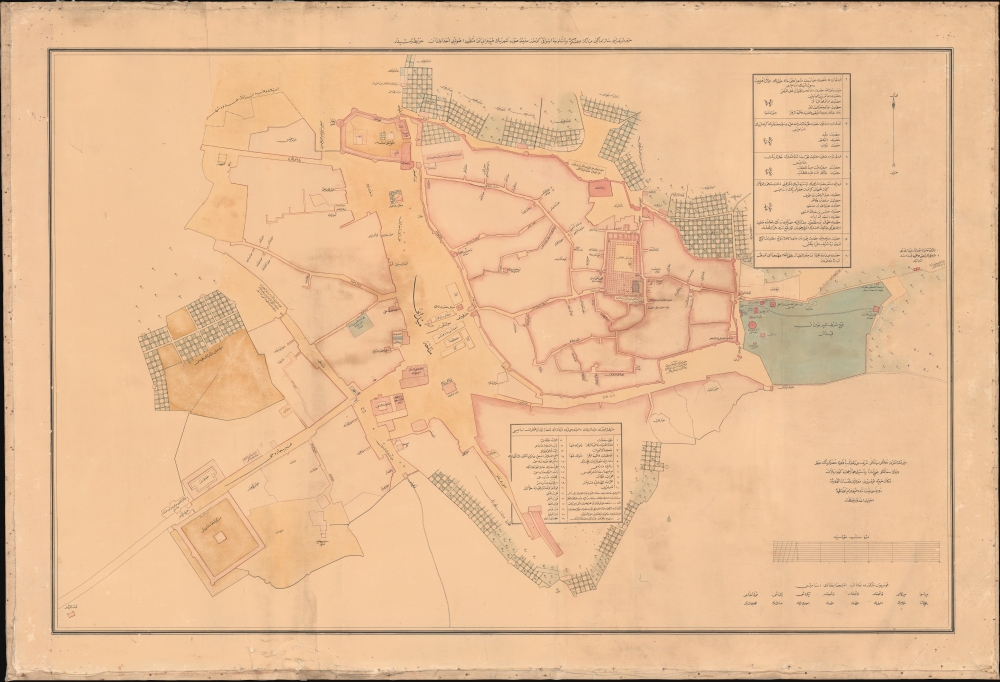


FOR THE ORIGINAL ANTIQUE MAP, WITH HISTORICAL ANALYSIS, CLICK HERE.
Digital Map Information
Geographicus maintains an archive of high-resolution rare map scans. We scan our maps at 300 DPI or higher, with newer images being 600 DPI, (either TIFF or JPEG, depending on when the scan was done) which is most cases in suitable for enlargement and printing.
Delivery
Once you purchase our digital scan service, you will receive a download link via email - usually within seconds. Digital orders are delivered as ZIP files, an industry standard file compression protocol that any computer should be able to unpack. Some of our files are very large, and can take some time to download. Most files are saved into your computer's 'Downloads' folder. All delivery is electronic. No physical product is shipped.
Credit and Scope of Use
You can use your digial image any way you want! Our digital images are unrestricted by copyright and can be used, modified, and published freely. The textual description that accompanies the original antique map is not included in the sale of digital images and remains protected by copyright. That said, we put significant care and effort into scanning and editing these maps, and we’d appreciate a credit when possible. Should you wish to credit us, please use the following credit line:
Courtesy of Geographicus Rare Antique Maps (http://www.geographicus.com).
How Large Can I Print?
In general, at 300 DPI, you should at least be able to double the size of the actual image, more so with our 600 DPI images. So, if the original was 10 x 12 inches, you can print at 20 x 24 inches, without quality loss. If your display requirements can accommodate some loss in image quality, you can make it even larger. That being said, no quality of scan will allow you to blow up at 10 x 12 inch map to wall size without significant quality loss. For more information, it is best consult a printer or reprographics specialist.
Refunds
If the high resolution image you ordered is unavailable, we will fully refund your purchase. Otherwise, digital images scans are a service, not a tangible product, and cannot be returned or refunded once the download link is used.
Abd al-Mutalib ibn Ghalib ibn Musa‘ad (1790 - January 29, 1880) was an Arab official who served three times as Emir and Grand Sharif of Mecca: briefly in 1827, then from 1851 - 1856, and finally from 1880 - 1881. Abd al-Mutalib was born in Mecca of the esteemed Hashemite Abd lineage, the same clan as the Prophet Muhammad. His noble lineage came with high status in Meccan society where his family was deeply rooted in the religious and social fabric of the Hejaz and the Islamic holy cities, Mecca and Medina. Little is known of his first rule as Emir and Grand Sharif of Mecca in 1827, as it lasted less than a year, after which he was dismissed due to the Egyptian occupation of Hejaz. His second rude, 1851 - 56, was more significant, marked by power struggles between the waning Ottoman Empire and rising tribal powers in the Arabian Peninsula. It was further disrupted by ongoing conflicts with his predecessor (and successor) Muhammad ibn Awn (1767 - 1858) over slavery: Abd al-Mutalib was pro-slavery and anti-Ottoman, while Muhammad ibn Awn was anti-slavery and pro-Ottoman. Abd al-Muttalib attempted to expel the Ottomans and was consequently forced out of power by the pro-Ottoman Awn in 1856, when Abd al-Muttalib himself was captured and sent to Istanbul. He returned to power in Mecca 1880, and this time attempted to work with Ottoman authorities and even foreign powers, mainly the English, to mitigate the influence of his sworn enemy, the powerful Ottoman general Osman Nuri Pasha (1832 - 1900). Nonetheless, in 1882 he was administratively replaced by a member of a rival Hashemite clan branch due to suspicions that he was opposed to Ottoman Sultan ‘Abd al-Hamid II. Despite the tumultuous nature of his three reigns, Abd al-Muttalib suzernity was also marked by efforts to enhance the Hajj experience, including improving infrastructure, safety, and pilgrim care. He is responsible for both the first (c. 1856) and second (1880) maps of Medina, the latter being the first scientific survey of the holy city. More by this mapmaker...
Copyright © 2025 Geographicus Rare Antique Maps | Geographicus Rare Antique Maps
This copy is copyright protected.
Copyright © 2025 Geographicus Rare Antique Maps