1817 Thomson Map of the Mediterranean Sea
MediterraneanSea-thomson-1817$250.00

Title
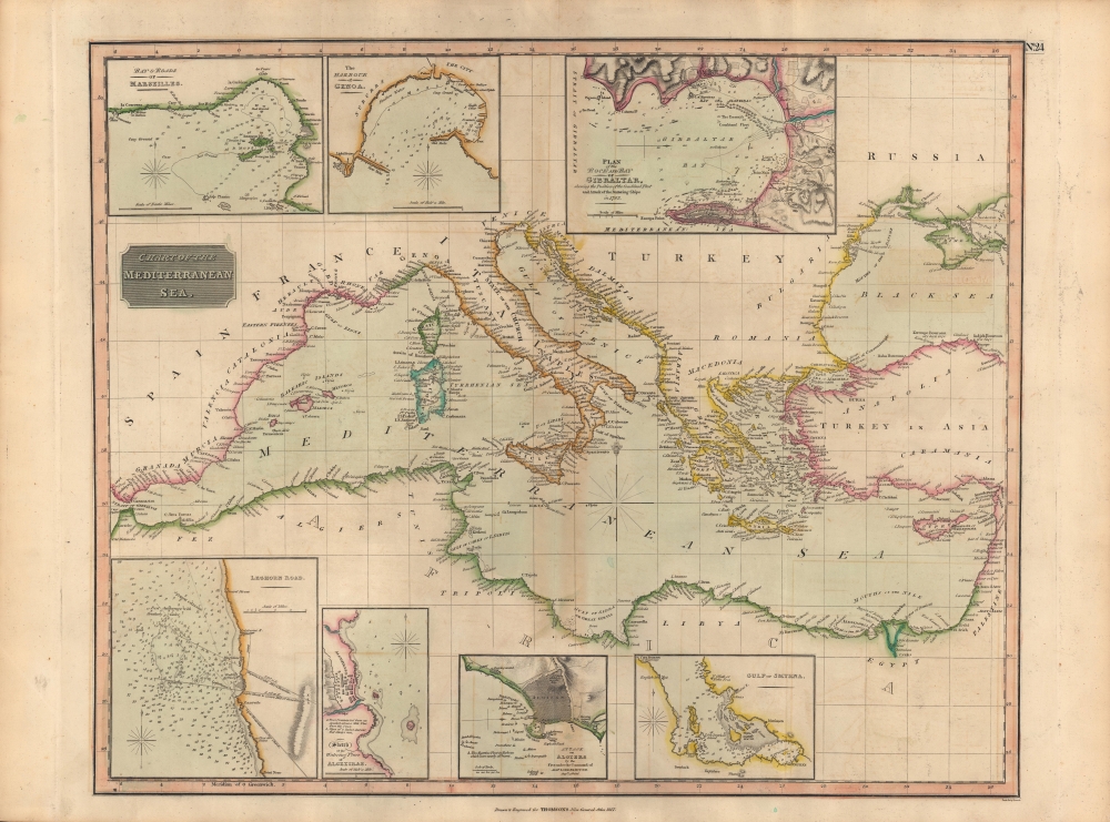
Chart of the Mediterranean Sea.
1817 (dated) 19.25 x 23.5 in (48.895 x 59.69 cm) 1 : 6300000
1817 (dated) 19.25 x 23.5 in (48.895 x 59.69 cm) 1 : 6300000
Description
A handsome 1817 map of the Mediterranean Sea produced for John Thomson's New General Atlas. It provides abundant information on the coasts and some of the main ports in the sea 'at the center of the world'.
A Closer Look
The sheet consists of a central map and seven insets, depicting, clockwise from top-left, the bay or harbors of Marseilles, Genoa, Gibraltar, Smyrna, Algiers, Algeciras, and Livorno. Banks, hazards, islets, and many coastal settlements are noted on the main map, while soundings, currents, and anchorages are provided in the insets. The insets also indicate important landward features for mariners, such as lighthouses, forts, and 'watering places'. Unlike most Thomson maps, this map includes considerable navigational data, including depth soundings. White not practical for navigation, the presence inclusion of such data underscores the Mediterranean's significance to European commerce, as well as its central role in the just-ended Napoleonic Wars.Publication History and Census
This map was engraved in 1817 by Samuel John Neele for inclusion in the first edition of John Thomson's New General Atlas. It is not independently cataloged among the holdings of any institution aside from the David Rumsey Historical Map Collection, while Thomson's entire atlas is more widely distributed in institutional collections.CartographerS
John Thomson (1777 - c. 1841) was a Scottish cartographer, publisher, and bookbinder active in Edinburgh during the early part of the 19th century. Thomson apprenticed under Edinburgh bookbinder Robert Alison. After his apprenticeship, he briefly went into business with Abraham Thomson. Later, the two parted ways, John Thomson segueing into maps and Abraham Thomson taking over the bookbinding portion of the business. Thomson is generally one of the leading publishers in the Edinburgh school of cartography, which flourished from roughly 1800 to 1830. Thomson and his contemporaries (Pinkerton and Cary) redefined European cartography by abandoning typical 18th-century decorative elements such as elaborate title cartouches and fantastic beasts in favor of detail and accuracy. Thomson's principle works include Thomson's New General Atlas, published from 1814 to 1821, the New Classical and Historical Atlas of 1829, and his 1830 Atlas of Scotland. The Atlas of Scotland, a work of groundbreaking detail and dedication, would eventually bankrupt the Thomson firm in 1830, at which time their plates were sequestered by the court. The firm partially recovered in the subsequent year, allowing Thomson to reclaim his printing plates in 1831, but filed again for bankruptcy in 1835, at which time most of his printing plates were sold to A. K. Johnston and Company. There is some suggestion that he continued to work as a bookbinder until 1841. Today, Thomson maps are becoming increasingly rare as they are highly admired for their impressive size, vivid hand coloration, and superb detail. More by this mapmaker...
Nathaniel Rogers Hewitt (July 19, 1783 - 1841) was a British engraver active in London during the first half of the 19th century. Hewitt was born in London on the 19th of July 1785. His map engraving work appears as early as 1804, although it is most commonly associated with the 1812 - 1817 atlas maps of publisher John Thomson. Hewitt also worked with James Wyld, Samuel William Fores, and other map publishers of the period. In 1824, Hewitt announced plans to independently publish a series of Parish maps by subscription, and a beautifully engraved map of St. Giles in the Fields followed. The map series must not have been able to attract many followers, as Hewitt declared bankruptcy shortly after in 1826. Learn More...
Source
Thomson, J., A New General Atlas, (Edinburgh: Baldwin, Cradock, Joy) 1817.
Thomson's New General Atlas was first published in 1817 and continued to be published until about 1821. This is the first of Thomson's major cartographic works and the atlas for which is most celebrated. The New General Atlas follows in the Edinburgh School, which eschews excessive decoration in favor of a more minimalistic fact-based cartographic vision, as established by John Pinkerton, Laurie and Whittle, John Cary, and others in the previous decades. The maps are notable for their massive scale, heavy stock, elegant color work, and easy-to-read typefaces. Although the atlas stopped being published after 1821, Thomson continued to offer 'supplementary' maps that could be tipped into the atlas as late as 1830, when he declared bankruptcy. The maps in the Thomson Atlas were engraved by Thomas Clerk, William Dassauville, Nathaniel Rogers Hewitt, James Kirkwood, Robert Kirkwood, John Menzies, George Menzies, Edward Mitchell, John Moffatt, Samuel John Neele, Robert Scott, and James Wyld.
Condition
Very good. Even toning. Some discoloration along fold line. Noticeable offsetting.
References
Rumsey 1007.025.