This item has been sold, but you can get on the Waitlist to be notified if another example becomes available, or purchase a digital scan.
1753 Vaugondy Map of the Southern Guyenne Region of France
MeridileGuienne-vaugondy-1757$125.00

Title
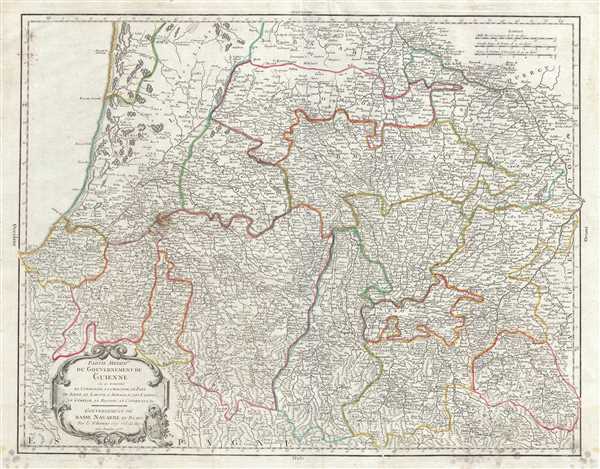
Partie Meridile. du Gouvernement de Guienne ou se trouvent le Condomois, la Chalosse, le Pays de Soule, le Labour, l'Armagnac, Les Landes, le Cominge, le Bigorre, le Conserans, &c. Gouvernement de Basse Navarre et Bearn.
1753 (dated) 20 x 25 in (50.8 x 63.5 cm) 1 : 419000
1753 (dated) 20 x 25 in (50.8 x 63.5 cm) 1 : 419000
Description
This is a scarce 1753 map of the southern Guyenne region of France by Robert de Vaugondy. It covers the south western portions of France including the departments of Hautes-Pyrenees, Pyrenees-Atlantiques or Basses-Pyrenees, Landes, Gers and Haute-Garonne. The map extends from Pampelune, Spain east to Saint-Lizier and north as far as Mimizan. The map renders the entire region in extraordinary detail offering both topographical and political information with forests and mountains beautifully rendered in profile.
The region of Haute-Garonne produces the delicious but lesser known Buzet wines, and tender Rocamadour cheeses. Hautes Pyrenees is home to the wine producing region, Madiran. Madrian is best known for producing a powerful red wine made from the Tannat grape. This area also makes a number of cheeses, including Tomme Noire des Pyrenees and Roquefort cheese. The Basses-Pyrenees department includes the Jurancon wine region, famous for its production dry wines and sweet white wines. The famous Pilgrimage to Santiago de Compostella passes through this heavily Basque region ultimately crossing the Pyrenees into Spain at St. Jean Pied-de-Port. Landes is known for its production of Chalossais, a white cow cheese with a gentle, acidic edge. Tursan wine is also distilled here, along with Armagnac brandy. Gers is known especially for its production of Armagnac Brandy and Floc de Gascogne, a sweet wine. It is also home to Cotes de Gascogne, a wine-growing district in Gascony producing white wine. This area is also famous for its foie gras and wild mushrooms.
The map includes a beautifully engraved title cartouche in the top left quadrant. This map was drawn by Robert de Vaugondy in 1753 and published in the 1757 issue of his Atlas Universal.
Cartographer
Robert de Vaugondy (fl. c. 1716 - 1786) was French may publishing from run by brothers Gilles (1688 - 1766) and Didier (c. 1723 - 1786) Robert de Vaugondy. They were map publishers, engravers, and cartographers active in Paris during the mid-18th century. The father and son team were the inheritors to the important Nicolas Sanson (1600 - 1667) cartographic firm whose stock supplied much of their initial material. Graduating from Sanson's maps, Gilles, and more particularly Didier, began to produce their own substantial corpus. The Vaugondys were well-respected for the detail and accuracy of their maps, for which they capitalized on the resources of 18th-century Paris to compile the most accurate and fantasy-free maps possible. The Vaugondys compiled each map based on their own geographic knowledge, scholarly research, journals of contemporary explorers and missionaries, and direct astronomical observation. Moreover, unlike many cartographers of this period, they took pains to reference their sources. Nevertheless, even in 18th-century Paris, geographical knowledge was limited - especially regarding those unexplored portions of the world, including the poles, the Pacific Northwest of America, and the interiors of Africa, Australia, and South America. In these areas, the Vaugondys, like their rivals De L'Isle and Buache, must be considered speculative or positivist geographers. Speculative geography was a genre of mapmaking that evolved in Europe, particularly Paris, in the middle to late 18th century. Cartographers in this genre would fill in unknown lands with theories based on their knowledge of cartography, personal geographical theories, and often dubious primary source material gathered by explorers. This approach, which attempted to use the known to validate the unknown, naturally engendered rivalries. Vaugondy's feuds with other cartographers, most specifically Phillipe Buache, resulted in numerous conflicting papers presented before the Academie des Sciences, of which both were members. The era of speculative cartography effectively ended with the late 18th-century explorations of Captain Cook, Jean Francois de Galaup de La Perouse, and George Vancouver. After Didier died, his maps were acquired by Jean-Baptiste Fortin, who in 1787 sold them to Charles-François Delamarche (1740 - 1817). While Delamarche prospered from the Vaugondy maps, he defrauded Vaugondy's window Marie Louise Rosalie Dangy of her rightful inheritance and may even have killed her. More by this mapmaker...
Source
Robert de Vaugondy, G., Atlas Universel, (Paris: Antoine Boudet) 1757.
The Atlas Universel was the crowning glory of the Robert de Vaugondy firm's atlas production. The atlas was revolutionary on many levels and exemplified the Vaugondy credo commode, complet, univorme, et suive (convenient, complete, uniform, and easy to use). The atlas thus consisted of a wide corpus of maps, both modern and historical, was of moderate height and width, and featured maps of uniform style and structure. They partnered with Antoine Boudet, a shrewd businessman and publisher with whom they had worked previously, to produce the 1752 first edition. To minimize his fiscal risk, Boudet sold the atlas first by subscription using a large prospectus, receiving in the process over 1100 pre-orders. The first edition appeared in 1752 and contained beautifully produced maps with elaborate freshly designed allegorical cartouche work, generally by Pierre-Edme Babel, Pierre Philippe Choffard, and Charles Nicholas Cochin. Most of the maps were engraved by the Delahaye firm, the payment for whose services ultimately led to legal disputes. Despite proving a popular work of astounding quality, the Atlas Universal received harsh criticism from fellow cartographers, particularly Philipppe Buache. Ever at odds with the Vaugondys, Buache's critical perspective may have been influenced more by political maneuvering than academic affront. The atlas was issued in multiple editions between 1752 and 1788. Later editions, issued after 1786, were taken over by Charles Delamarche, who inherited the Robert de Vaugondy firm and assumed Boudet's publication rights.
Condition
Very good. Minor wear along original centerfold. Original platemark visible. Some spotting and offsetting with water stains near borders. Stain and minor damage near lower left quadrant. Overall age toning.
References
Rumsey 3353.044. Pedley, Mary Sponberg Belle et Utile: The Work of the Robert de Vaugondy Family of Mapmakers, 150, state 2.