This item has been sold, but you can get on the Waitlist to be notified if another example becomes available, or purchase a digital scan.
1578 Munster Map of the Fertile Crescent: Cyprus, the Holy Land, Syria, Iraq
Mesopotamia-munster-1540$375.00


Title
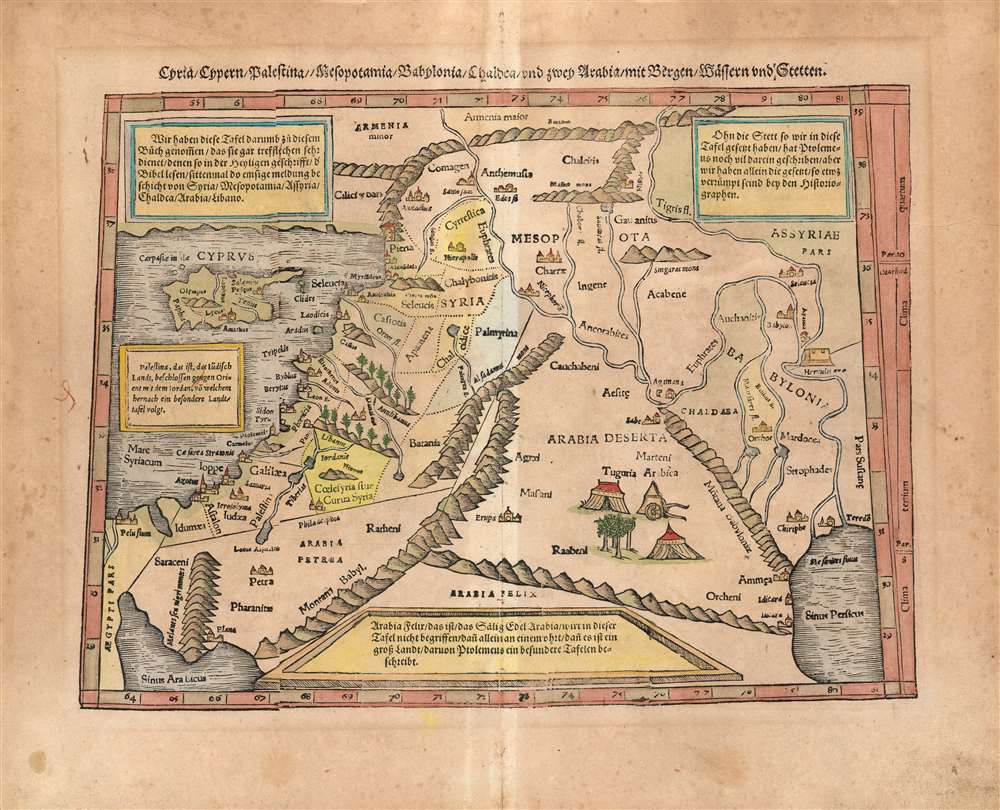
Cyria/ Cypern/ Palestina//Mesopotamia/Chaldea/und zwei Arabia/mit Bergen/Wåssern und Stetten.
1540 (undated) 10.25 x 13.5 in (26.035 x 34.29 cm) 1 : 6000000
1540 (undated) 10.25 x 13.5 in (26.035 x 34.29 cm) 1 : 6000000
Description
This is Sebastian Münster's 1540 map of the Holy Land, Cyprus and the Fertile Crescent, from the 1578 German edition of Munster's Cosmographia Universalis. One of Münster's scarcest maps, it is one of his Ptolemaic works - derived from the Alexandrian geographer's second century geographic information, as passed along (probably) via Waldseemüller's 1513 Quarta Asiae Tabula. Being a smaller woodcut, Münster's work necessarily simplifies the 1513 map, but what it lacks in size the present work makes up for in its informative qualities: four typeset text boxes describe the contents of the map in detail (here in German: the text was re-set for the various editions.)
Scope of the Map
Following the Ptolemaic model, this simple conic projection map shows the region from the eastern Mediterranean Sea to the northern Persian Gulf. The area enclosed thus includes the island of Cyprus, all of the Holy Land, Syria, and the watershed of the Tigris and Euphrates Rivers - modern day Iraq and Kuwait. Also, the map includes the northern portions of Arabia: stony Arabia and Desert Arabia, as distinct from 'Happy Arabia' or 'Arabia Felix' which can be glimpsed to the south.An Attractive Woodcut
Like the Waldseemuller before it, Münster's map shows mountains pictorially. It goes further in depicting forests as well: the wooded mountains of Lebanon are shown, for instance. Also, in Arabia Deserta can be seen tents and wagons set about an oasis, indicating the nomadic peoples reputed to live there. On the shore of the Tigris River can be seen a 'Fortress of Hercules.' Cities, too, are shown pictorially: Babylon, Petra, Jaffa, Jerusalem, Sidon, Tyre, Beirut, Damascus, and many others are shown.Scarce, Old Color Example
Sebastian Münster's maps were not, as a rule, colored when they left his publisher's house. The color on this map, however, shows distinct evidence of having been applied prior to binding (see the lack of age-toning along the centerfold of the map, indicating that it was tightly bound and not receiving the soot and/or light which has toned the rest of the page.) As was very often the case with these maps, we expect that the Cosmographeyfrom which this example was taken was rebound - perhaps as early as the 17th or 18th centuries - prior to which the maps received the color seen here, as well as the neat manuscript retouching to make the woodblock cracks less obtrusive.Publication History and Census
This map was introduced in the first 1540 edition of Munster's Geographia. It remained in each edition of that work, but was included in only eight of the German editions of Munster's Cosmographia making it scarcer than most maps appearing in Münster's oeuvre. The typographical variations identify it clearly as belonging to the 1578 German edition of the map. German editions of Cosmographia are well represented in institutional collections.CartographerS
Sebastian Münster (January 20, 1488 - May 26, 1552), was a German cartographer, cosmographer, Hebrew scholar and humanist. He was born at Ingelheim near Mainz, the son of Andreas Munster. He completed his studies at the Eberhard-Karls-Universität Tübingen in 1518, after which he was appointed to the University of Basel in 1527. As Professor of Hebrew, he edited the Hebrew Bible, accompanied by a Latin translation. In 1540 he published a Latin edition of Ptolemy's Geographia, which presented the ancient cartographer's 2nd century geographical data supplemented systematically with maps of the modern world. This was followed by what can be considered his principal work, the Cosmographia. First issued in 1544, this was the earliest German description of the modern world. It would become the go-to book for any literate layperson who wished to know about anywhere that was further than a day's journey from home. In preparation for his work on Cosmographia, Münster reached out to humanists around Europe and especially within the Holy Roman Empire, enlisting colleagues to provide him with up-to-date maps and views of their countries and cities, with the result that the book contains a disproportionate number of maps providing the first modern depictions of the areas they depict. Münster, as a religious man, was not producing a travel guide. Just as his work in ancient languages was intended to provide his students with as direct a connection as possible to scriptural revelation, his object in producing Cosmographia was to provide the reader with a description of all of creation: a further means of gaining revelation. The book, unsurprisingly, proved popular and was reissued in numerous editions and languages including Latin, French, Italian, and Czech. The last German edition was published in 1628, long after Münster's death of the plague in 1552. Cosmographia was one of the most successful and popular books of the 16th century, passing through 24 editions between 1544 and 1628. This success was due in part to its fascinating woodcuts (some by Hans Holbein the Younger, Urs Graf, Hans Rudolph Manuel Deutsch, and David Kandel). Münster's work was highly influential in reviving classical geography in 16th century Europe, and providing the intellectual foundations for the production of later compilations of cartographic work, such as Ortelius' Theatrum Orbis Terrarum Münster's output includes a small format 1536 map of Europe; the 1532 Grynaeus map of the world is also attributed to him. His non-geographical output includes Dictionarium trilingue in Latin, Greek, and Hebrew, and his 1537 Hebrew Gospel of Matthew. Most of Munster's work was published by his stepson, Heinrich Petri (Henricus Petrus), and his son Sebastian Henric Petri. More by this mapmaker...
Claudius Ptolemy (83 - 161 AD) is considered to be the father of cartography. A native of Alexandria living at the height of the Roman Empire, Ptolemy was renowned as a student of Astronomy and Geography. His work as an astronomer, as published in his Almagest, held considerable influence over western thought until Isaac Newton. His cartographic influence remains to this day. Ptolemy was the first to introduce projection techniques and to publish an atlas, the Geographiae. Ptolemy based his geographical and historical information on the "Geographiae" of Strabo, the cartographic materials assembled by Marinus of Tyre, and contemporary accounts provided by the many traders and navigators passing through Alexandria. Ptolemy's Geographiae was a groundbreaking achievement far in advance of any known pre-existent cartography, not for any accuracy in its data, but in his method. His projection of a conic portion of the globe on a grid, and his meticulous tabulation of the known cities and geographical features of his world, allowed scholars for the first time to produce a mathematical model of the world's surface. In this, Ptolemy's work provided the foundation for all mapmaking to follow. His errors in the estimation of the size of the globe (more than twenty percent too small) resulted in Columbus's fateful expedition to India in 1492.
Ptolemy's text was lost to Western Europe in the middle ages, but survived in the Arab world and was passed along to the Greek world. Although the original text almost certainly did not include maps, the instructions contained in the text of Ptolemy's Geographiae allowed the execution of such maps. When vellum and paper books became available, manuscript examples of Ptolemy began to include maps. The earliest known manuscript Geographias survive from the fourteenth century; of Ptolemies that have come down to us today are based upon the manuscript editions produced in the mid 15th century by Donnus Nicolaus Germanus, who provided the basis for all but one of the printed fifteenth century editions of the work. Learn More...
Heinrich Petri (1508 - 1579) and his son Sebastian Henric Petri (1545 – 1627) were printers based in Basel, Switzerland. Heinrich was the son of the printer Adam Petri and Anna Selber. After Adam died in 1527, Anna married the humanist and geographer Sebastian Münster - one of Adam's collaborators. Sebastian contracted his stepson, Henricus Petri (Petrus), to print editions of his wildly popular Cosmographia. Later Petri, brought his son, Sebastian Henric Petri, into the family business. Their firm was known as the Officina Henricpetrina. In addition to the Cosmographia, they also published a number of other seminal works including the 1566 second edition of Nicolaus Copernicus's De Revolutionibus Orbium Coelestium and Georg Joachim Rheticus's Narratio. Learn More...
Source
Münster, Sebastian Cosmography oder Beschreibung aller Lände, (Basel: Petri) 1578.
The Cosmographia Universalis, one of the greatest geographical and historical works of the 16th century, 'taught nearly three generations of laymen most of what they knew about the world beyond their native places' (Strauss). Filled with maps, views, and rich descriptions of places throughout Europe and beyond, it was the best general source of geographical information until the advent of Ortelius' Theatrum. It was first issued by Sebastian Munster (1488 - 1552) in its 1544 German edition, and stayed in print long after its author's death in thirty five editions, and in five languages. (Of these, the 1550 and 1552 editions are widely regarded as the most complete and truest to the author's intentions: thereafter, later editors continued to add to the work's text; editions from 1588 onwards employed an entirely different set of maps produced on Ortelius' model.) Munster's goal, initially, was to rally his homeland's humanists and scholars to produce a new map of Germany in order to 'see what kind of a land our ancestors conquered for their home... bring honor to our country and place its beauties in the clear light of day.' Munster's project quickly expanded to cover the known world in its scope to produce a 'sufficiently large volume, in which I touch upon the foundation of all nations and kingdoms, their peculiarities, rivers, mountains, customs of men, royal successions, origins of the more important cities, succinct histories, religions, characteristics and fertility of lands... in Germany, however, I tarry a little longer'.
Munster's methodology in Cosmographia is notable in particular for his dedication to providing his readers with direct access to firsthand reports of his subjects wherever possible. Many of the maps were the result of his own surveys; others, the fruit of an indefatigable letter writing campaign to scholars, churchmen and princes throughout Europe, amicably badgering them for maps, views, and detailed descriptions of their lands. For lands further afield than his letters could reach, Munster relied on the best that the authorities of northern European scholarship could offer: he was well familiar with the work of Waldseemuller and other geographers of the early 16th century, and was well connected with the best geographers of his own generation. A disproportionate number of the maps of Cosmographia show contemporary geographical knowledge of the their respective areas for the very first time: The first map to show the continents of the Western Hemisphere; the first map to focus on the continent of Asia; the first modern map to name the Pacific Ocean; the first map to use a key; the first modern map of the British Isles and so on. Even in cases where earlier maps exist, Munster's works very often remain the earliest such acquirable by the collector.
Munster's methodology in Cosmographia is notable in particular for his dedication to providing his readers with direct access to firsthand reports of his subjects wherever possible. Many of the maps were the result of his own surveys; others, the fruit of an indefatigable letter writing campaign to scholars, churchmen and princes throughout Europe, amicably badgering them for maps, views, and detailed descriptions of their lands. For lands further afield than his letters could reach, Munster relied on the best that the authorities of northern European scholarship could offer: he was well familiar with the work of Waldseemuller and other geographers of the early 16th century, and was well connected with the best geographers of his own generation. A disproportionate number of the maps of Cosmographia show contemporary geographical knowledge of the their respective areas for the very first time: The first map to show the continents of the Western Hemisphere; the first map to focus on the continent of Asia; the first modern map to name the Pacific Ocean; the first map to use a key; the first modern map of the British Isles and so on. Even in cases where earlier maps exist, Munster's works very often remain the earliest such acquirable by the collector.
Condition
Very good. Evenly toned, barring the space along the centerfold gutter. Few marginal mends not impacting image. Old (17th-18th c?) hand color.
References
OCLC 163145825 (1574 issue). See also Rumsey 11623.047. (1540 first state).