1897 Poole Bros. Map of the Mexican Southern Railway
MexicanSouthernRailway-poolebros-1897$350.00


Title
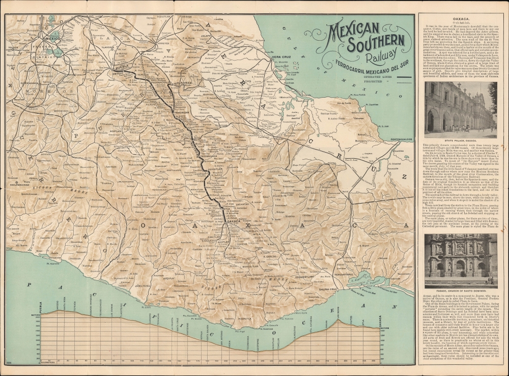
Mexican Southern Railway Ferrocarril Mexicano del Sur. / Mexican Southern Railway F.C. Mexicano del Sur to Oaxaca and Southern Mexico Only Route to the Ruins of Mitla.
1897 (undated) 15 x 21 in (38.1 x 53.34 cm) 1 : 1300000
1897 (undated) 15 x 21 in (38.1 x 53.34 cm) 1 : 1300000
Description
A scarce c. 1897 map of the Mexican Southern Railway and other rail lines in southern Mexico, most likely printed by Poole Brothers of Chicago.
After nearly being nominated for a third time at the 1880 Republican National Convention and instead leaving politics, Grant was approached with various business opportunities. Romero had secured a concession from the government of Oaxaca to build a railroad towards Mexico City (and eventually in the other direction to Guatemala) and asked Grant to be president of the new company. They were able to secure financiers, and the company was incorporated in the state of New York in early 1881. Given Grant's stature, the project received significant attention in the U.S. However, the logistical difficulties of surveying, let alone building, through densely forested valleys and mountains, led to slow progress. By 1884, investors began to flee, and the company went bankrupt; the following year, Grant died, and the project temporarily died with him.
The concession was passed around to different entrepreneurs until the British company Read and Campell acquired it in 1888 and began construction on a more limited line between Puebla and Oaxaca, completed in 1892. The company was financially successful and helped to link Oaxaca to the national and international economy, as had been hoped for in the original conception by Romero and Grant. In 1909, the Ferrocarril Interoceánico de México obtained a lease on the Mexican Southern, and both lines were nationalized in 1936. Today, the line's former station in Oaxaca City is a museum dedicated to the railway (Museo del Ferrocarril Mexicano del Sur).
A Closer Look
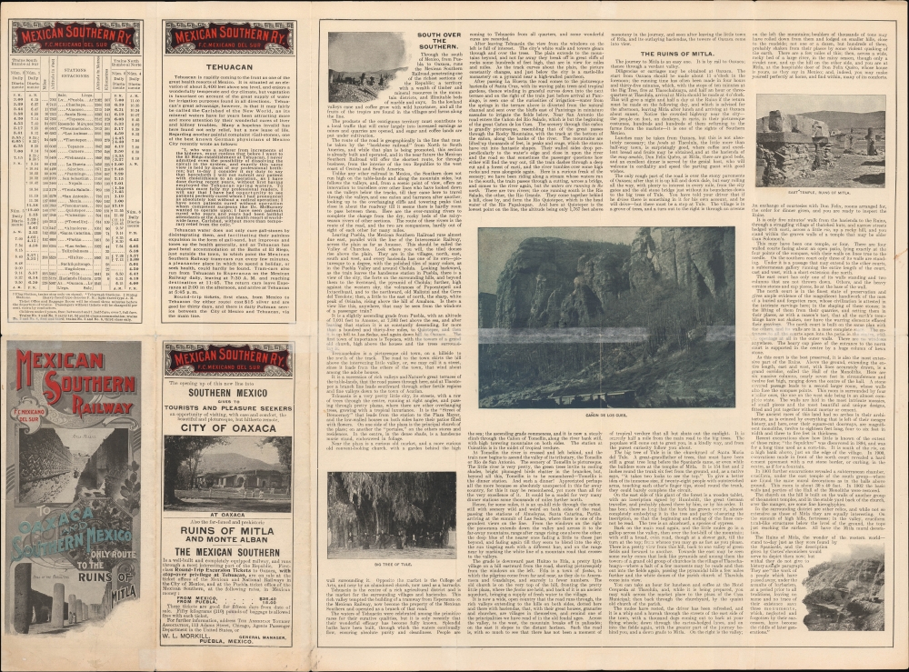
The map displays a portion of southern Mexico between Mexico City and Tehuantepec. The projected line of the Mexican Southern Railway is marked with a bold black line running north to south from Puebla to Oaxaca. Other already constructed and proposed rail lines are also noted, including the Interoceanic Railway (Ferrocarril Interoceánico), Vera Cruz and Pacific Railway, and Tehuantepec Railroad. At right on the recto and on the verso, promotional text and images appear, relating to Oaxaca, Tehuacán, the railway route, and the ruins of Mitla.Mexican Southern Railway
The Mexican Southern Railway (Ferrocarril Mexicano del Sur), later known as the Mexican Southern Railroad, was a railway company that operated in Mexico during the late 19th and early 20th centuries. It was established to connect Mexico City with Oaxaca, linking much of Mexico's central and southern regions in the process and facilitating transportation and economic development in previously inaccessible areas. The railway was originally conceived by Ulysses S. Grant, who had an interest in Mexico since his service in the Mexican-American War, and Matías Romero, a native Oaxacan who served as Mexico's ambassador to the U.S. for much of the 1860s when Mexico was invaded and partially occupied by French forces.After nearly being nominated for a third time at the 1880 Republican National Convention and instead leaving politics, Grant was approached with various business opportunities. Romero had secured a concession from the government of Oaxaca to build a railroad towards Mexico City (and eventually in the other direction to Guatemala) and asked Grant to be president of the new company. They were able to secure financiers, and the company was incorporated in the state of New York in early 1881. Given Grant's stature, the project received significant attention in the U.S. However, the logistical difficulties of surveying, let alone building, through densely forested valleys and mountains, led to slow progress. By 1884, investors began to flee, and the company went bankrupt; the following year, Grant died, and the project temporarily died with him.
The concession was passed around to different entrepreneurs until the British company Read and Campell acquired it in 1888 and began construction on a more limited line between Puebla and Oaxaca, completed in 1892. The company was financially successful and helped to link Oaxaca to the national and international economy, as had been hoped for in the original conception by Romero and Grant. In 1909, the Ferrocarril Interoceánico de México obtained a lease on the Mexican Southern, and both lines were nationalized in 1936. Today, the line's former station in Oaxaca City is a museum dedicated to the railway (Museo del Ferrocarril Mexicano del Sur).
Railways and the Porfiriato
The U.S.-aligned government of Porfirio Díaz (1830 - 1915, himself a native Oaxacan), who led Mexico in the late 19th and early 20th centuries, was enthusiastic about infrastructure projects such as telegraph lines and railways. Though correct in assuming these would boost economic growth, the government was at best indifferent to how much these policies would help ordinary people, especially laborers in the mines and agricultural plantations who powered the increased productivity. The highly uneven distribution of wealth and reliance on exploitative labor practices caused social tension to build up throughout Mexico, resulting in a revolution in 1910 followed by a decade-long civil war.Publication History and Census
This map is undated, but from context (existing and projected rail lines), it most likely dates to the final years of the 19th century. The Mexican Southern, which began operation in 1892, is referred to as a 'new line' on the verso. Yet, the Ferrocarril de Tlacotepec a Huajuapan de León, which was approved and began construction in 1897, is included. There is no publication information, but the title, subject, style, and numbering system at the bottom-left on the recto all suggest that Poole Brothers printed the map. Three institutions in the OCLC list a map with this title among their collections: the University of California Berkeley, the University of Arizona, and Yale University (Beinecke). They all differ from the present map, though the example held by the Beinecke is most similar, even matching the number at the bottom-left (2380), but it is apparently uncolored and lacks the text and images on the verso.Cartographer
Poole Brothers (1878 - 1968) were a Chicago based firm active in the late 19th and early 20th century with an initial focus on promotional railroad maps. Poole Brothers was founded by George Amos Poole (March 20, 1843 – September 7, 1918). In 1868, Poole, along with his uncle William H. Rand (1828 - 1915) and Andrew McNally (1836 - 1904), purchased the Chicago Tribune's job printing plant and formed the firm Rand McNally. In 1878, he left Rand McNally to form, with his brother William H. Poole, Poole Brothers, a direct competitor to Rand McNally for the lucrative railroad business. Like many of its competitors, Poole Brothers maintained an office on Chicago's Printer's Row (downtown Loop district). Their earliest known work is an 1880 map of Yellowstone National Park. In 1887, Poole Brothers, Andrew McNally, and several others formed the United Typothetae of America, a master printers association. In 1848, they were cited, along with Rand McNally and George Cram, by the Federal Trade Commission for price fixing. Their earliest known work is an 1880 map of Yellowstone National Park. Afterward they went on to produce a vast range of maps and other print products including tickets, cards, coupons, and restaurant menus. In time Poole Brothers merged with Newman-Randolph, which was then acquired by the American Can Company in the early 1960s. The American Can Company liquidated its printing concerns later in the same decade. More by this mapmaker...
Condition
Good. Light wear along original fold lines. Verso repairs to several fold separations. Slight loss at a few fold intersections. Text and printed images on verso.
References
OCLC 33211529.