This item has been sold, but you can get on the Waitlist to be notified if another example becomes available, or purchase a digital scan.
1592 Ortelius Map of Mexico
Mexico-ortelius-1592$500.00

Title
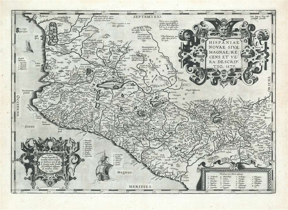
Hispaniae Novae Sivae Magnae, Recens et Vera Descriptio. 1579.
1592 (dated 1579) 13.5 x 19.75 in (34.29 x 50.165 cm) 1 : 2000000
1592 (dated 1579) 13.5 x 19.75 in (34.29 x 50.165 cm) 1 : 2000000
Description
This is a superb example of Ortelius' 1579 Map of Mexico, the first Atlas map of New Spain, in a Latin-text edition of 1592. It shows Spanish settlements in the interior, and an array of rivers and lakes both actual and imagined. The beautifully executed strapwork cartouches are embellished with putti, heads in native headgear, and ferocious beasts.
The Map
The map embraces central and western Mexico, including Mexico City in the southeast, Compostela in the west, Guadalajara and Michoacan in the central part of the map. Queretero and San Miguel de Allende are also marked on the map. In addition to these recognizable place names, there are marked on the map a number of Spanish military encampments, suggesting continuing campaigns to subdue indigenous populations in the central part of Mexico. Exhibiting such detail, the map is certainly derived from a first-hand report, though sadly and uncharacteristically Ortelius does not provide a source. The best report that comes down to us is Eduard Brandmair's 1914 attribution of the map to the French cartographer Jean Duran, based on a note by the eighteen‐century mapmaker and editor, Didier Robert de Vaugondy. This source map does not appear to have survived.A Modern Work
In addition to containing contemporary information, the map is presented within a modern cartographical framework. Ortelius explains to the reader, in Latin text to the lower left of the map: 'To the reader; the beginning of the longitude on this map we have not, in the Ptolemaic fashion taken from the Canary Islands towards the East, but from the Spanish meridian in Toledo towards the West.' By deviating from Ptolemaic convention, Ortelius places the work squarely in the 16th century, as opposed to Ptolemy's era in the second century.Publication History and Census
Van den Broecke estimates that approximately 6675 copies of this map were printed over the period the map was included in Ortelius' atlas, and it is fair to assume that perhaps ten percent of these have survived in one form or another. About fifteen copies of various editions of the map appear in OCLC collections; the map appears on the market with some regularity with wild variations in condition.Cartographer
Abraham Ortelius (April 14, 1527 - June 28, 1598) also known as Ortels, was a cartographer, geographer, and cosmographer of Brabant, active in Antwerp. He was the creator of the first modern atlas, Theatrum Orbis Terrarum and is a seminal figure in the history of cartography. Along with Gerard Mercator and Gemma Frisius, he was a founder of the Netherlandish school of cartography. His connections with Spain - culminating in his 1575 appointment as Royal Cartographer to King Phillip II of Spain - gave him unmatched access to Spanish geographical knowledge during a crucial period of the Age of Discovery. Ortelius was born in 1527 in Antwerp. In 1547 he entered the Antwerp Guild of Saint Luke as an illuminator of maps. He began trading in books, prints, and maps, traveling regularly to the Frankfurt book and print fair, where in 1554 he met Mercator. He accompanied Mercator on journeys throughout France in 1560 and it was at this time, under Mercator's influence, that he appears to have chosen his career as a scientific geographer. His first published geographic work appeared in 1564, an eight-sheet cordiform world map. A handful of other maps preceded the 1570 publication of the first edition of the Theatrum Orbis Terrarum, which would prove to be his life work. Appearing with but 53 maps in its first edition, Ortelius' work expanded with new maps added regularly. By 1592, it had 134 maps. Many of Ortelius' maps remained the standard for nearly a century. He traveled extensively, but his genius was as a compiler, locating the best informed maps on which to base his own. His contacts throughout Europe and extending even (via the Portuguese) to the Far East were formidable. Moreover, many of his maps were based on his own scholarship, particularly his historical works. His theories of geography were particularly ahead of his time with respect to the notion of continental drift, the possibility of which he mused on as early as 1596, and which would be proven correct centuries later.
In a sense his greatest achievement was his successful navigation of the religious and political violence endemic to his city throughout his adult life: The Dutch Revolt, or Eighty Years' War (1568 - 1648), fully embroiled Antwerp. Although outwardly and officially recognized as Catholic (Arias Montanus vouched for Ortelius' Catholic orthodoxy prior to his appointment as Royal Geographer), Ortelius was able to separate himself from the religious furor which characterized the war in the low countries. Ortelius showed a glimpse of himself in a letter to a friend, regarding humanist Justus Lipsius: 'I do not know whether he is an adherent of the Pope or a Calvinist, but if he has ears to hear, he will neither be one nor the other, for sins are committed on both sides'. Ortelius' own explorations of Biblical history in his maps, and the Christogram contained in his own motto, suggest him to be a religious man, but his abjuration of political religious authorities mark him as an individualist. His tombstone at St Michael's Præmonstratensian Abbey in Antwerp bears the inscription, Quietis cultor sine lite, uxore, prole. ('served quietly, without accusation, wife, and offspring.') More by this mapmaker...
Source
Ortelius A., Theatrum Orbis Terrarum, (Antwerp), Latin Edition, 1592.
Abraham Ortelius' magnum opus, Theatrum Orbis Terrarum, was the world's first regularly produced atlas, which 'set the standards for later atlases . . . It was the first undertaking of its kind to reduce the best available maps to an uniform format.' (Koeman) A modestly-sized work of fifty-three maps in its first edition of May 1570, it was an immediate success: there were three further editions that year, and the work remained in print for a total of 32 editions, the last of which was 1641, well after its author's 1598 death. Ortelius added to his atlas constantly, and by 1595 the Theatrum contained 147 maps. Ortelius is renowned generally as an editor, and indeed much of the Theatrum is compiled from a variety of sources: in such cases, Ortelius was scrupulous in naming his sources. But Ortelius was also a mapmaker in his own right: many of his maps are a distillation of various sources into his own work, and there were many maps - particularly in his atlas of Biblical and ancient history Parergon - which were entirely Ortelius' work. In his role as an editor, Ortelius followed in the footsteps of Munster, whose Cosmographia was, until Ortelius, the best window on the world for the curious European reader. In terms of the artistry of his maps, Ortelius oversaw the first great flourishing of copperplate engraving in the service of cartography to occur in Northern Europe. Ortelius' work provided the model for the atlases of Mercator, Hondius, Blaeu and all their progeny in the 17th century - many of whom were to produce faithful editions of Ortelius' maps in their own productions.
Condition
Very good condition. Reinforced upper corners, else excellent with a remarkably bold, sharp strike.
References
Rumsey 10001.069. OCLC 9540720. Koeman Ort 72. Van der Krogt 9510:31. Van den Broecke Ort 13.