This is Samuel Augustus Mitchell's 1846 map of Mexico and Central America, with Texas as a republic and near its fullest extent, based on an earlier map by Henry Schenck Tanner. It is especially significant as it coincides with the incorporation of Texas into the Union and the beginning of the Mexican-American War (1846 - 1848), which would significantly alter the borders displayed here.
A Closer Look
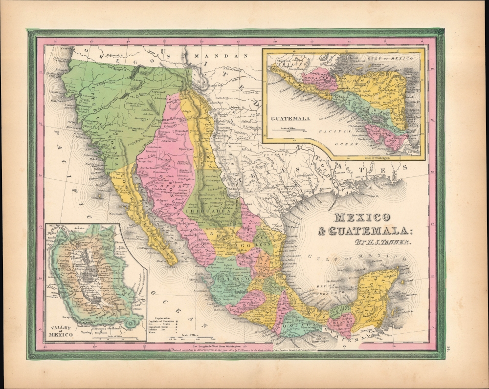
Coverage includes Mexico, Central America, Upper California, Texas, and the territory that would later form Arizona and New Mexico. Political and topographical features are noted and color coded with elevation rendered by hachure. Cities, forts, mines, frontier settlements, Native American groups, and missions are labeled. The bottom left features and inset of the Valley of Mexico and Mexico City. In the upper right another inset focuses on the general vicinity of Guatemala, Nicaragua, Honduras, Costa Rica, and El Salvador. The whole is colored in Mitchell's distinctive style with green border work and vivid pastels. Features the early Carey and Hart border design.Upper California and Texas
The presentation of Upper California and Texas are especially notable. In the case of the former, the geography is still quite sketchy and lacks the information provided by Frémont's expeditions, as can be seen in the San Francisco Bay area as well as the inclusion of apocryphal features like the Buenaventura River linking to a southern Salt Lake. Similarly, the Russian Establishment north of San Francisco (Fort Ross) had been abandoned several years prior.
Texas here includes lands between the Rio Pecos (here as Puerco) and Rio Grande (Rio Bravo del Norte), and as far north as the (Salt Fork) Arkansas River. Colonies, land grants, and early cities are prominently marked out, including Austin's Colony and Grant. Texas only joined the Union at the end of 1845, and Mitchell's map maintains it as an independent republic here. Republic of Texas
The Republic of Texas was a short-lived nation established in March 1836 when it seceded from Mexico. Following the independence of Mexico from Spain, the American Stephen Fuller Austin led a group of 300 Empresarios to settle Texas, near Austin, where they received a grant from the Mexican government. As more Americans moved to Texas, resentment and strife began to build between the American settlers and Mexican authorities. This and other factors ultimately led to the Texan Revolution in 1835 and the declaration of Texan independence in 1836. Texas remained an independent republic until it joined the United States ten years later in 1846.Texas Borders
The borders of the Republic of Texas were in dispute from the earliest days of the Texan Revolution. The Republic-claimed borders followed the Treaties of Velasco between the newly created Texas Republic and Mexican leader, Antonio López de Santa Anna. The treaties established an eastern boundary following the 1819 Adams-Onís Treaty between the United States and Spain, which established the Sabine River as the eastern boundary of Spanish Texas and the western boundary of the Missouri Territory. The Republic's southern and western boundary with Mexico was more nuanced. Texas claimed the Rio Grande del Norte as its western and southernmost border, while Mexico argued for a boundary much further east at the Nueces River. When Texas was annexed into the United States, the agreement followed the Republic claimed boundary, thus absorbing Mexican claimed territory as far west as Santa Fe. This escalated already existing tensions between the United States, the former Republic of Texas, and Mexico, ultimately triggering the Mexican-American War (1846 -1848). Publication History and Census
Though this map is attributed to Henry Schenck Tanner and the copyright is dated 1834, it appeared in Samuel Augustus Mitchell's 1846 New Universal Atlas. This map and the atlas were first published by Tanner in 1836, and then were published from 1843 by Carey and Hart, who converted the engraved plates to lithographs. Mitchell inherited the atlas in 1846 and published it until 1849, making this the first edition of the map published by him. Compared to Tanner's earlier editions of the map, some updates and changes have been made, but the changes between this edition and Mitchell's 1849 edition were more significant, 'fixing' the geography of Upper California and adding it to the United States.
Two printings of the atlas were issued in 1846, with the present example representing the first; in the second, held by the David Rumsey Historical Map Collection (0537.037), the copyright is updated to 1846 and is held by H.N. Burroughs, though Tanner's name is maintained below the title. A separately-issued folding pocket map of Mexico and Guatemala was also published in 1846 by C.S. Williams, who added his own copyright in the bottom margin while maintaining Tanner's 1834 copyright within the neatline (Rumsey 4800.001).
CartographerS
Samuel Augustus Mitchell (March 20, 1792 - December 20, 1868) began his map publishing career in the early 1830s. Mitchell was born in Bristol, Connecticut. He relocated to Philadelphia in 1821. Having worked as a school teacher and a geographical writer, Mitchell was frustrated with the low quality and inaccuracy of school texts of the period. His first maps were an attempt to rectify this problem. In the next 20 years Mitchell would become the most prominent American map publisher of the mid-19th century. Mitchell worked with prominent engravers J. H. Young, H. S. Tanner, and H. N. Burroughs before attaining the full copyright on his maps in 1847. In 1849 Mitchell either partnered with or sold his plates to Thomas, Cowperthwait and Company who continued to publish the Mitchell's Universal Atlas. By about 1856 most of the Mitchell plates and copyrights were acquired by Charles Desilver who continued to publish the maps, many with modified borders and color schemes, until Mitchell's son, Samuel Augustus Mitchell Junior, entered the picture. In 1859, S.A. Mitchell Jr. purchased most of the plates back from Desilver and introduced his own floral motif border. From 1860 on, he published his own editions of the New General Atlas. The younger Mitchell became as prominent as his father, publishing maps and atlases until 1887, when most of the copyrights were again sold and the Mitchell firm closed its doors for the final time. More by this mapmaker...
Henry Schenck Tanner (1786 - May 18, 1858) was one of the preeminent American map engravers and publishers of the early 19th century - what is considered to be the "Golden Age of American Map Publishing". Born in New York City but based in Philadelphia, Tanner's forty plus year career was almost entirely focused on cartographic work. His earliest map work appears in conjunction with another important map publisher, John Melish. Early in his career, Tanner partnered with his brother Benjamin, to engrave extensively for Melish as well as other Philadelphia publishers including Lucas Fielding (Baltimore), A. Bourne, Jason Torey, Samuel Harrison, and Samuel Lewis, among others. In 1818 Tanner convinced his fellow publishers and partners to finance the compilation of a New American Atlas. The atlas was sold by subscription and slowly emerged between 1819 and 1823. The New American Atlas, possibly the pinnacle of 19th century American cartography and was commended in its day as "one of the most splendid works of the kind ever executed in this country". It was subsequently republished in several updated editions until about 1839. Tanner had by this time become the most active and influential map publisher in the United States. Around 1832, recognizing the market for a less cost prohibitive atlas, Tanner began work on the smaller format New Universal Atlas. This popular and important atlas went through numerous editions before being bought out by Carey and Hart, and then, in 1846, by S. A. Mitchell, who would rise to become the preeminent publisher of the next generation. In addition to these important atlases, Tanner also issued numerous extremely important and influential travelers guides, state maps, wall maps, and pocket maps. He should not be confused with his brother, also an America map engraver, the New Yorker Benjamin Tanner. Learn More...
Source
Mitchell, S.A., A New Universal Atlas Containing Maps of the various Empires, Kingdoms, States, and Republics of the World…, (Philadelphia: Mitchell) 1846.
The New Universal Atlas is one of the great American atlases of the mid-19th century. Samuel Augustus Mitchell first issued the atlas in 1846 when he acquired the map plates and copyright for Tanner's New Universal Atlas from its publisher, Carey and Hart. The first transitional 1846 edition was published jointly with Carey and Hart, but a second edition was published in the same year with the Tanner imprint erased. This edition of the atlas also introduced the signature S. A. Mitchell green and pink color scheme. Most of the maps from the early editions of the atlas were engraved by H. N. Burroughs or C. S. Williams, often bearing their copyright. Burroughs maps also tended to have what map collector David Rumsey refers to as the 'Cary and Hart' borders, which featured a narrow vine motif. These borders were replaced, along with the Burroughs imprint, with the more traditional Mitchell strap work border used in the atlases until 1856. Mitchell published editions until late in 1850, when he sold the rights to Thomas, Cowperthwait and Company of Philadelphia. Under Cowperthwait, the atlases continued to be published and bear the Mitchell name until 1856, when the plates were again sold, this time to Charles Desilver. Desilver reworked the plates with new border art and a revised color scheme in the style of J. H. Colton. Desilver issued editions from 1857 to 1860, when the atlas was phased out in favor of Samuel Augustus Mitchell Jr.'s New General Atlas.
Very good. Slight toning in the margins.
Rumsey 0537.037.