This copy is copyright protected.
Copyright © 2025 Geographicus Rare Antique Maps
Digital Image: 1868 Farmer's Railroad and Township Map of Michigan
Michigan-farmer-1868-2_d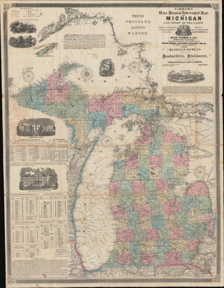


FOR THE ORIGINAL ANTIQUE MAP, WITH HISTORICAL ANALYSIS, CLICK HERE.
Digital Map Information
Geographicus maintains an archive of high-resolution rare map scans. We scan our maps at 300 DPI or higher, with newer images being 600 DPI, (either TIFF or JPEG, depending on when the scan was done) which is most cases in suitable for enlargement and printing.
Delivery
Once you purchase our digital scan service, you will receive a download link via email - usually within seconds. Digital orders are delivered as ZIP files, an industry standard file compression protocol that any computer should be able to unpack. Some of our files are very large, and can take some time to download. Most files are saved into your computer's 'Downloads' folder. All delivery is electronic. No physical product is shipped.
Credit and Scope of Use
You can use your digial image any way you want! Our digital images are unrestricted by copyright and can be used, modified, and published freely. The textual description that accompanies the original antique map is not included in the sale of digital images and remains protected by copyright. That said, we put significant care and effort into scanning and editing these maps, and we’d appreciate a credit when possible. Should you wish to credit us, please use the following credit line:
Courtesy of Geographicus Rare Antique Maps (http://www.geographicus.com).
How Large Can I Print?
In general, at 300 DPI, you should at least be able to double the size of the actual image, more so with our 600 DPI images. So, if the original was 10 x 12 inches, you can print at 20 x 24 inches, without quality loss. If your display requirements can accommodate some loss in image quality, you can make it even larger. That being said, no quality of scan will allow you to blow up at 10 x 12 inch map to wall size without significant quality loss. For more information, it is best consult a printer or reprographics specialist.
Refunds
If the high resolution image you ordered is unavailable, we will fully refund your purchase. Otherwise, digital images scans are a service, not a tangible product, and cannot be returned or refunded once the download link is used.
John Farmer (February 9, 1798 - March 24, 1859) was an American cartographer based in Detroit, Michigan, in the first half of the 19th century. Farmer was born in the town of Half Moon, Saratoga County, New York where he trained to become a school teacher, mastering, among other academic skills, drafting. At the time, Michigan Territory has a shortage of school teachers and, in 1821, recruited Farmer to head the Lancasterian School in Detroit. Farmer supplemented his salary by using his drafting skills to copy manuscript surveys for new settlers arriving in Michigan. This work must have brought him to the attention government officials, who employed him to compile and draft a map of Michigan's first federally funded road. In 1826, he also published, along with Orange Risdon, one of the earliest maps of Michigan. Working in the 1830s, Farmer taught himself engraving in order to issue a second, more detailed map focusing on the southern half of Michigan's lower peninsula. In 1835, he issued an important general map of the Territories of Michigan and Wisconsin, which became one of his most enduring maps, going the various editions for nearly 25 years. Most of his early map plates he sold to J. H. Colton, who republished them under his own name and imprint. In 1844, Farmer issued State of Michigan and the Surrounding Country, the map that most defined his career. It became the essential Michigan map, indispensable for anyone planning to emigrate to Michigan, do business, or even move about the state. He updated and revised this map throughout the remainder of his life. He also issued a rare wall map of Michigan measuring 5 x 6 ft. After his death, in March of 1859, following a long mental decline, the Farmer map plates passed to his widow Rachel, and sons, Silas, Arthur, and John, who continued the business under Farmer's imprint. More by this mapmaker...
Silas Farmer (June 6, 1839 - December 28, 1902) was an American publisher, historian, and author, and son of the famous cartographer John Farmer. Silas began his career working with his father in the family publishing firm, and continued working for the firm after his father's death. Silas published at least three histories of Detroit, Michigan, entitled The History of Detroit and Michigan (1884), All About Detroit (1899), Guide and Souvenir of Detroit (1891). He died suddenly on December 28, 1902 of an apparent heart attack. Silas married Orpha C. Littlefield in 1868. Learn More...
Copyright © 2025 Geographicus Rare Antique Maps | Geographicus Rare Antique Maps
This copy is copyright protected.
Copyright © 2025 Geographicus Rare Antique Maps