Title
Missouri et Arkansas.
1890 (dated)
24.75 x 18 in (62.865 x 45.72 cm)
1 : 1500000
Description
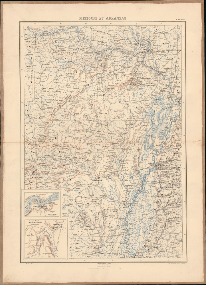
This map of Missouri and Arkansas during the U.S. Civil War was prepared by Ernest Dumas-Vorzet for the scarce 1890 atlas volume of Philippe d'Orléans' Histoire de la Guerre Civile en Amérique.
A Closer Look
Arkansas and Missouri south of the Missouri River are displayed, as well as portions of neighboring states and territories, with roads, railroads, cities, towns, waterways, mountains, and other features recorded in great detail. Two inset maps appear at the bottom-left, with the first presenting Lexington, Missouri. A city on the Missouri River east of Kansas City, Lexington was the site of two of the largest battles west of the Mississippi River during the Civil War, in September 1861 and October 1864, respectively. The second inset map presents the battlefield of Wilson's Creek or White Oak south of Springfield, the first major battle of the war west of the Mississippi River, which took place on August 10, 1861.Missouri and Arkansas in the U.S. Civil War
Missouri and Arkansas were part of the Trans-Mississippi Theater of the U.S. Civil War, but the states' experience of the war was also somewhat distinct from fighting in Tennessee, Mississippi, and Louisiana, since they lay west of the Mississippi River.
Being a border state that saw intense violence even before any southern states seceded, Missouri played a complex and pivotal role in the U.S. Civil War. Though a slave state, it remained in the Union, making it a battleground for both Confederate and Union forces. The state's divided loyalties led to intense guerrilla warfare, with pro-Union and pro-Confederate groups fighting throughout the region and often committing atrocities against perceived sympathizers of the other side. (After the war, many Confederate 'bushwhackers' turned to banditry, including the notorious James-Younger Gang.) Missouri's government, backed by the Union, was often at odds with secessionist factions within the state. The state's position was crucial for both sides, given its key geographic location along the Mississippi River and its access to vital transportation routes. Missouri's internal conflict was marked by significant violence and unrest, including the infamous 1863 raid on Lawrence, Kansas, by Confederate guerrillas, which killed 164 civilians. The Lawrence raid was a reprisal for a smaller pro-Union raid on Osceola that had killed 9 pro-Confederate civilians. (Lawrence had also been sacked before the war, in 1856, by pro-slavery raiders. That confrontation resulted in one death.)
For its part, Arkansas was still mostly a sparsely populated frontier when the Civil War broke out. With less of a slave-holding elite or vested reliance on the slave trade, the state was less enthusiastic about secession. Nonetheless, some pro-Confederate hotheads attacked the Federal Arsenal in Little Rock in February 1861. The state initially seemed inclined to stay in the Union before seceding in May 1861 in the fallout from the rebels' capture of Fort Sumter. Arkansas' strategic location along the Mississippi River made it vital for Confederate efforts to control the western part of the Confederacy and secure supplies, such as food and timber, for the Confederate war effort. The state was the site of several important battles, including the Battle of Pea Ridge (or Elkhorn Tavern) in March 1862 (a decisive Union victory that helped secure control of northern Arkansas). After a series of Union victories and the eventual fall of Little Rock in 1863, Arkansas was largely under Union control by the war's end. It had even mustered units for the Union cause, drawing on a degree of residual opposition to secession. At the same time, Confederate sympathies remained strong in parts of the state, and Union troops fared poorly in the field after capturing Little Rock, especially during the disastrous Red River Campaign in the Spring of 1864.Publication History and Census
This map was drafted by Ernest Dumas-Vorzet, engraved by Louis Wuhrer, printed by Becquet, and published by Michel Lévy in Paris for the 1890 French edition of Philippe d'Orléans' Histoire de la Guerre Civile en Amérique. The atlas supplement, of which this map was part, was issued only with the 1890 French publication and was not included in any of the earlier English editions. The entire work, in this edition, is uncommon in institutional collections, with only 3 being identified in OCLC, and is scarce to the market. Most examples lack the atlas, which in OCLC appears only at the Boston Athenaeum. Very little market history.
CartographerS
Ernest Dumas-Vorzet (18?? - 18??) was a French line and letter engraver active in Paris in the late 19th century. He engraved the lettering on nautical charts for the Dépôt des Cartes et Plans de la Marine. His later work is often associated with Émile Delaune (18?? - 19??) and Hachette et Cie. He is likely the father of Edouard Dumas-Vorzet, a French publisher and cartographer. More by this mapmaker...
Frédéric Louis Charles Wuhrer (1844 - 1925) was a French cartographer, engraver, and artist. He lived in the town of Buc, France, where he purchased the former Town Hall. Wuhrer is better known as a landscape artist, with a strong record at auctions. Little is known of his engraving work, but the Bibliothèque nationale de France has over one hundred pieces in their collection attributed to his name. Learn More...
Louis-Philippe-Albert d'Orléans, Comte de Paris (August 24, 1838 - September 8, 1894) was a French prince, scholar, officer in the American Civil War (1861 - 1865), and unofficially King of France (February 24, 1848). Louis-Philippe-Albert was the grandson of French king, Louis Philippe I of the house of Orléans. With the advent of the French Second Republic (1848 - 1852), Louis-Philippe-Albert and his family fled to the United States. Louis-Philippe-Albert became an outspoken journalist who, when the Civil War broke out, volunteered to serve in the Union Army, being instantly appointed assistant adjutant general under General George McClellan with the rank of captain. During his service, he used the abbreviated name Philippe d'Orléans. He served in the Peninsular Campaign, the first large-scale offensive in the Eastern Theater, but resigned from service in July 1862. Later, he wrote a History of the Civil War in America, published in 1875. He returned to Europe in 1864, where in England, he married his paternal first cousin, Princess Marie Isabelle d'Orléans (1848–1919), Infanta of Spain. In 1871, after the Franco-Prussian War and the downfall of Napoleon III, they were allowed to return to France, and many of their properties were restored. He renounced all claims to the French throne in 1873 but was still considered by some Orléanists as Philippe VII of France. In 1886, the prince and his family again went into exile in London, where he died in 1894. Learn More...
Michel Lévy (1821 - May 4, 1875) was a French publisher and founder of the Michel Lévy Frères publishing house. Born in Phalsbourg in the Moselle to a bookseller (colporteur), he began selling books in Paris at the age of fifteen under the name Michel Lévy Frères. Although his brothers Kalmus (Calmann) and Nathan were sometimes involved in his business, Michel was the primary bookseller and later publisher. Initially, Lévy focused on works relating to the theater, but later expanded into literature, periodicals, and other fields. By the 1860s, Michel Lévy Frères was one of the major publishers in France, putting out works by the likes of Honoré de Balzac, Gustave Flaubert, and Victor Hugo. Michel Lévy was inducted into the Légion d'Honneur in 1873, but died unexpectedly two years later. Afterwards, his brother took charge of the firm, then renamed Calmann Lévy (sometimes as Calmann-Lévy), and it continued its success as a leading publisher in France. In 1893, Calmann turned over the business to his three sons, Georges, Paul, and Gaston, who ran it until the Second World War, when Gaston was interned by the Nazis and the publishing house was renamed Editions Balzac. After the war, the firm continued and still exists today as a subsidiary of Hachette. Learn More...
Source
Orleans, Louis-Philippe-Albert d', Histoire de la Guerre Civile en Amérique, par M. le comte de Paris, (Paris: Michel Lévy) 1890.
Condition
Good. Backed on old linen. Original centerfold exhibits some toning and wear.
References
LC Civil War Maps (2nd ed.), 80. Library of Congress G1201.S5 P3 1890. OCLC 877854495, 13501746.