Digital Image: 1886 Lewis Map of Mobile Bay, Alabama
MobileBay-lewis-1880s_d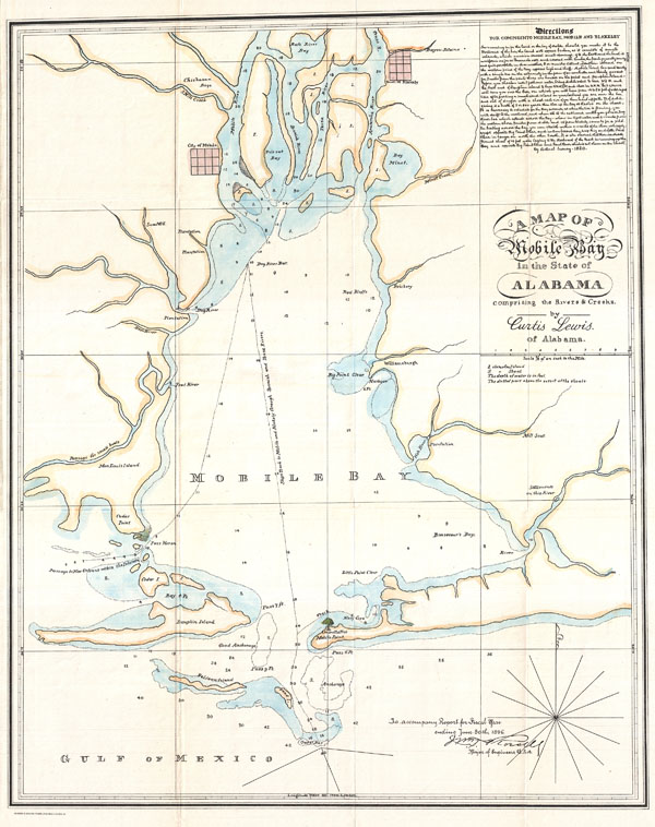

Title
A Map of Mobile Bay in the State of Alabama comprising the Rivers & Creeks.
1886 (dated) 20.5 x 16.5 in (52.07 x 41.91 cm)
1886 (dated) 20.5 x 16.5 in (52.07 x 41.91 cm)
Description
FOR THE ORIGINAL ANTIQUE MAP, WITH HISTORICAL ANALYSIS, CLICK HERE.
Digital Map Information
Geographicus maintains an archive of high-resolution rare map scans. We scan our maps at 300 DPI or higher, with newer images being 600 DPI, (either TIFF or JPEG, depending on when the scan was done) which is most cases in suitable for enlargement and printing.
Delivery
Once you purchase our digital scan service, you will receive a download link via email - usually within seconds. Digital orders are delivered as ZIP files, an industry standard file compression protocol that any computer should be able to unpack. Some of our files are very large, and can take some time to download. Most files are saved into your computer's 'Downloads' folder. All delivery is electronic. No physical product is shipped.
Credit and Scope of Use
You can use your digial image any way you want! Our digital images are unrestricted by copyright and can be used, modified, and published freely. The textual description that accompanies the original antique map is not included in the sale of digital images and remains protected by copyright. That said, we put significant care and effort into scanning and editing these maps, and we’d appreciate a credit when possible. Should you wish to credit us, please use the following credit line:
Courtesy of Geographicus Rare Antique Maps (http://www.geographicus.com).
How Large Can I Print?
In general, at 300 DPI, you should at least be able to double the size of the actual image, more so with our 600 DPI images. So, if the original was 10 x 12 inches, you can print at 20 x 24 inches, without quality loss. If your display requirements can accommodate some loss in image quality, you can make it even larger. That being said, no quality of scan will allow you to blow up at 10 x 12 inch map to wall size without significant quality loss. For more information, it is best consult a printer or reprographics specialist.
Refunds
If the high resolution image you ordered is unavailable, we will fully refund your purchase. Otherwise, digital images scans are a service, not a tangible product, and cannot be returned or refunded once the download link is used.
Cartographer
William Trent Rossell (October 11, 1849 - October 11, 1919) was born in Alabama on October 11, 1849, the son and grandson of Army officers, and he graduated third in the United States Military Academy class of 1873. Commissioned in the Corps of Engineers, he served until 1880 at Willets Point and as Assistant Professor of Engineering at the Military Academy. He then engaged in river, harbor, and fortification work in regions around Portland, Maine; Jacksonville, Florida; and Vicksburg, Mississippi. Rossell served in 1891-93 as the Engineer Commissioner on the three-member governing board of the District of Columbia. After briefly commanding the Battalion of Engineers, he led Mobile District for six years. He then supervised lighthouse construction and repair in the New York area and, later, Ohio River improvements. He was a member of the Mississippi River Commission from 1906 to 1913, as well as Central Division Engineer in 1908-09 and Eastern Division Engineer in 1909-13. He retired October 11, 1913, but was recalled to active service in 1917. He led the Third New York and Puerto Rico districts and was Northeast Division Engineer. He again retired in 1918. He died October 11, 1919, in Staten Island, New York. More by this mapmaker...
Source
Rossell, William, Report for the Fiscal Year ending June 30th, 1896, 1896.
References
Phillips (America), p. 446.