This copy is copyright protected.
Copyright © 2025 Geographicus Rare Antique Maps
Digital Image: 1838 Karacsay Map of Montenegro
Montenegro-karacsay-1838_d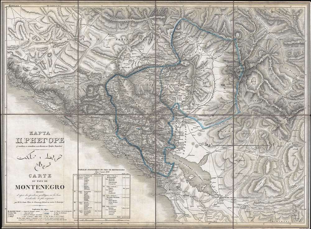

FOR THE ORIGINAL ANTIQUE MAP, WITH HISTORICAL ANALYSIS, CLICK HERE.
Digital Map Information
Geographicus maintains an archive of high-resolution rare map scans. We scan our maps at 300 DPI or higher, with newer images being 600 DPI, (either TIFF or JPEG, depending on when the scan was done) which is most cases in suitable for enlargement and printing.
Delivery
Once you purchase our digital scan service, you will receive a download link via email - usually within seconds. Digital orders are delivered as ZIP files, an industry standard file compression protocol that any computer should be able to unpack. Some of our files are very large, and can take some time to download. Most files are saved into your computer's 'Downloads' folder. All delivery is electronic. No physical product is shipped.
Credit and Scope of Use
You can use your digial image any way you want! Our digital images are unrestricted by copyright and can be used, modified, and published freely. The textual description that accompanies the original antique map is not included in the sale of digital images and remains protected by copyright. That said, we put significant care and effort into scanning and editing these maps, and we’d appreciate a credit when possible. Should you wish to credit us, please use the following credit line:
Courtesy of Geographicus Rare Antique Maps (http://www.geographicus.com).
How Large Can I Print?
In general, at 300 DPI, you should at least be able to double the size of the actual image, more so with our 600 DPI images. So, if the original was 10 x 12 inches, you can print at 20 x 24 inches, without quality loss. If your display requirements can accommodate some loss in image quality, you can make it even larger. That being said, no quality of scan will allow you to blow up at 10 x 12 inch map to wall size without significant quality loss. For more information, it is best consult a printer or reprographics specialist.
Refunds
If the high resolution image you ordered is unavailable, we will fully refund your purchase. Otherwise, digital images scans are a service, not a tangible product, and cannot be returned or refunded once the download link is used.
Fedor von Karacsay (1787 - 1859) was a Hungarian cartographer, artist, and adventurer. A member of a Hungarian noble family, little is known about his childhood, though records show that he was a graduate of the Theresianum, a prestigious Austrian military academy in Wiener Neustadt. He as a cadet in the Austrian army by 1805 and held the rank of lieutenant while serving at the 1813 Battle of Dresden, a major engagement during the Napoleonic Wars. Early in his military career, Karacsay received formal training in military engineering and advanced survey methods. A remarkable soldier who had distinguished himself due to his ability and drive, he had been promoted to the rank of colonel by the 1830s and was given the highly important post of garrison commander of Cattaro (Kotor). Located on the Bay of Kotor not far from the Dalmatian coast, the city was a flashpoint in the region, since it was an Austrian-controlled port city with a majority Slavic population. Montenegro openly coveted the city, and, while open warfare never broke out between the Montenegrins and the Austrians, relations were always tense at best. Karacsay, however, had a kind and genial demeanor that endeared him to the locals, as did the reality of his time as garrison commander, which was gentler and more culturally sensitive than that of his predecessors. Despite the tension and near hostility between the two nations, Karacsay was invited to visit the court of the Montenegrin vladika Petar II Petrović-Njegoš in Cetinje in 1836. The two became fast friends and formed a lasting friendship that transcended national rivalries. It was because of this relationship that Karacsay was able to complete and publish the first scientific survey of the interior of Montenegro. After his tour of duty in Kotor ended, Karacsay was posted throughout the world, including as the head of the Habsburg mission in Belgrade and as special envoy to Sultan Abdülmecid I in Constantinople. Due to this intellect and capacity for writing, Karacsay published several travel books about his journeys. By the early 1850s, Karacsay was posted in Brno, and later Budapest, where he developed a fascination for Pan-Turanism, the idea that Hungarians share a common ancestry with the Turkic peoples as well as other Asiatic ethnic groups. In his desire to find these links between Hungarian and Asian cultures, he traveled to Herat, Balkh, Bohara, and Samarkand. Karacsay died in Tehran in 1859 holding the rank of General. More by this mapmaker...
Copyright © 2025 Geographicus Rare Antique Maps | Geographicus Rare Antique Maps
This copy is copyright protected.
Copyright © 2025 Geographicus Rare Antique Maps