This copy is copyright protected.
Copyright © 2025 Geographicus Rare Antique Maps
Digital Image: 1846 Pedro Pico Plan of Montevideo, Uruguay (During the Great Siege)
Montevideo-pico-1846_d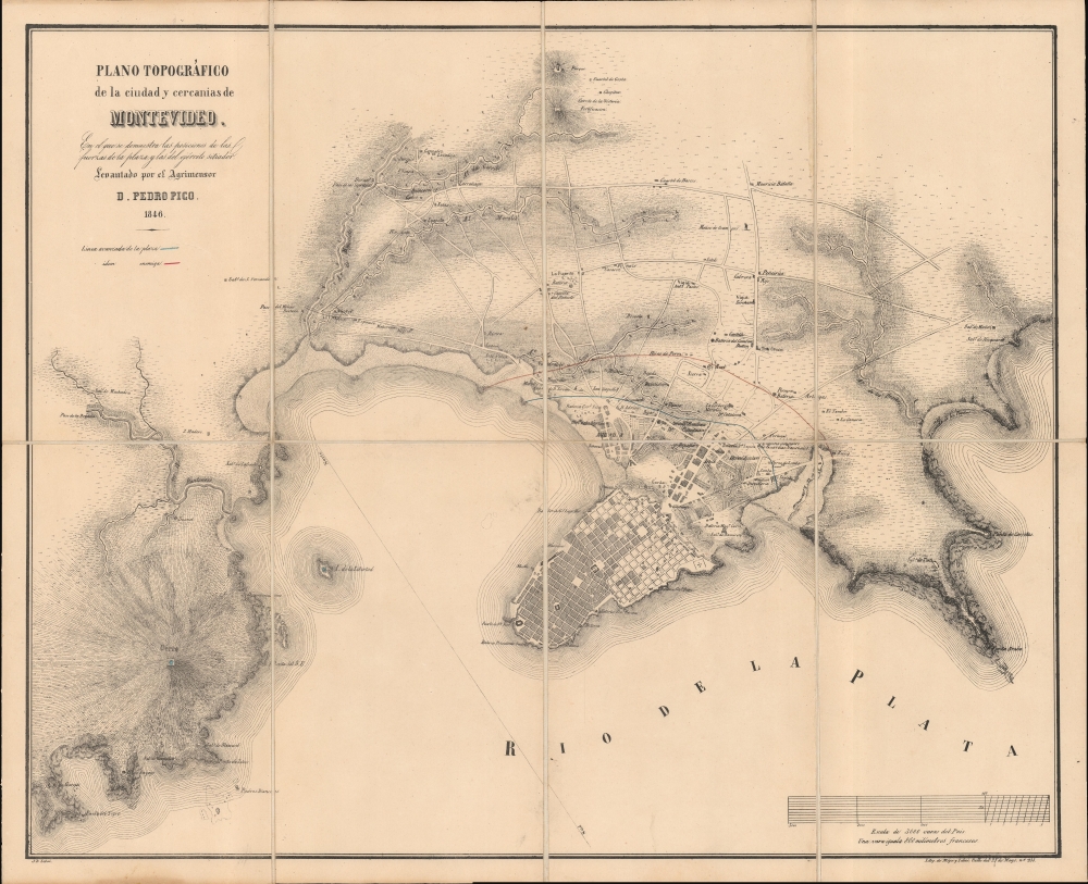


FOR THE ORIGINAL ANTIQUE MAP, WITH HISTORICAL ANALYSIS, CLICK HERE.
Digital Map Information
Geographicus maintains an archive of high-resolution rare map scans. We scan our maps at 300 DPI or higher, with newer images being 600 DPI, (either TIFF or JPEG, depending on when the scan was done) which is most cases in suitable for enlargement and printing.
Delivery
Once you purchase our digital scan service, you will receive a download link via email - usually within seconds. Digital orders are delivered as ZIP files, an industry standard file compression protocol that any computer should be able to unpack. Some of our files are very large, and can take some time to download. Most files are saved into your computer's 'Downloads' folder. All delivery is electronic. No physical product is shipped.
Credit and Scope of Use
You can use your digial image any way you want! Our digital images are unrestricted by copyright and can be used, modified, and published freely. The textual description that accompanies the original antique map is not included in the sale of digital images and remains protected by copyright. That said, we put significant care and effort into scanning and editing these maps, and we’d appreciate a credit when possible. Should you wish to credit us, please use the following credit line:
Courtesy of Geographicus Rare Antique Maps (http://www.geographicus.com).
How Large Can I Print?
In general, at 300 DPI, you should at least be able to double the size of the actual image, more so with our 600 DPI images. So, if the original was 10 x 12 inches, you can print at 20 x 24 inches, without quality loss. If your display requirements can accommodate some loss in image quality, you can make it even larger. That being said, no quality of scan will allow you to blow up at 10 x 12 inch map to wall size without significant quality loss. For more information, it is best consult a printer or reprographics specialist.
Refunds
If the high resolution image you ordered is unavailable, we will fully refund your purchase. Otherwise, digital images scans are a service, not a tangible product, and cannot be returned or refunded once the download link is used.
Pedro Pico (1810 - 1886) was an Argentine surveyor. Born in Buenos Aires, he was educated as an engineer in England. Returning to America, he became a surveyor for Uruguay. By 1837, he was employed in that capacity by the Department of Mines; some manuscripts of his have survived from that period. With the advent of the Uruguayan Civil War, he moved to Montevideo and joined the forces holding the city against Rosas. He produced a plan of the city in 1845 during the course of the siege, marking the positions of the opposing forces. In its first edition, it is one of the earliest maps printed in Uruguay. Following the war, Pico returned home to Buenos Aires where he taught classes at the University and joined the Topographic Department. He also produced geographical map of the province of Entre Ríos, during the period in which it was governed by General Urquiza. He retired to Rivadavia in Argentina, and died in 1886. More by this mapmaker...
Copyright © 2025 Geographicus Rare Antique Maps | Geographicus Rare Antique Maps
This copy is copyright protected.
Copyright © 2025 Geographicus Rare Antique Maps