This item has been sold, but you can get on the Waitlist to be notified if another example becomes available, or purchase a digital scan.
1785 Lodge Map of the Mosquito / Mosquitia (Nicaragua and Costa Rica)
MosquitoShore-lodge-1785$275.00

Title
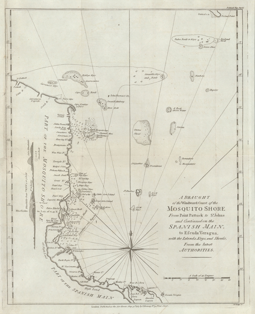
A Draught of the Windward Cost of the Mosquito Shore from Point Pattuck to St. Johns and Continued on the Spanish Main, to Escuda Veragua with the Islands, Keys, and Shoals, From the latest Authorities.
1785 (dated) 15 x 12 in (38.1 x 30.48 cm) 1 : 2500000
1785 (dated) 15 x 12 in (38.1 x 30.48 cm) 1 : 2500000
Description
This is a scarce 1785 John Lodge map of the Mosquitia or Mosquito Coast, roughly corresponding to present-day eastern Nicaragua and Costa Rica. The map was issued to illustrate the heated colonial conflict between England and Spain over the remote and inhospitable coastline.
In general, the Mosquitia was poorly mapped, and this map remained the best obtainable map of the region well into the 19th century. We have been able to unearth little about the Field survey, but it was probably associated with Britsh attempts to settle the coast.
In 1785, the Spanish, hoping to capitalize on British preoccupation with the American Revolutionary War (1775 - 1783), attempted to seize British settlements around the Black River area, Cape Gracias a Dios, and Bluefields. With their Miskito allies, the British settlers were able to drive off the Spanish raiders, but the issue remained a hot point of political contention between England and Spain.
The issue was resolved as this map was being published by the 1785-86 Convention of London. The resulting treaty between Britain and Spain called for a British withdrawal from Mosquitia in exchange for Spanish recognition of British settlements in Belize (British Honduras). Leading up to this treaty, Mosquitia was a semi-autonomous region, with the Miskito playing a delicate role, balancing their interests between the European powers. The Miskito raided Spanish settlements and aided British privateers, further complicating Spanish efforts to assert control.
While Spain nominally claimed sovereignty over Mosquitia, its control was limited by the rugged terrain, lack of infrastructure, and strong resistance from the Miskito. The region's remoteness, combined with its reliance on British support, set the stage for ongoing disputes between colonial powers and local Indigenous leaders in the decades that followed. To this day, Mosquitia remains one of the least populous and most inaccessible parts of Central America.
A Closer Look
Coverage embraces the Mosquitia, being the Gulf Coast of Costa Rica and Nicaragua, extending roughly from Puerto Lembira south to Bocas del Torro, Panama. The map is derived from a similar map of the same title surveyed by Captain Stephen Field and published in London by Mount and Page c. 1765.In general, the Mosquitia was poorly mapped, and this map remained the best obtainable map of the region well into the 19th century. We have been able to unearth little about the Field survey, but it was probably associated with Britsh attempts to settle the coast.
Historical Context
In 1785, the Mosquitia region, located along the eastern coast of present-day Nicaragua and Honduras, became a hotspot for colonial competition between Britain and Spain. Britain had established a strong presence in Mosquitia through alliances with the indigenous Miskito Kingdom, who were staunch British allies, benefiting from British weapons, trade, and support in resisting Spanish encroachments.In 1785, the Spanish, hoping to capitalize on British preoccupation with the American Revolutionary War (1775 - 1783), attempted to seize British settlements around the Black River area, Cape Gracias a Dios, and Bluefields. With their Miskito allies, the British settlers were able to drive off the Spanish raiders, but the issue remained a hot point of political contention between England and Spain.
The issue was resolved as this map was being published by the 1785-86 Convention of London. The resulting treaty between Britain and Spain called for a British withdrawal from Mosquitia in exchange for Spanish recognition of British settlements in Belize (British Honduras). Leading up to this treaty, Mosquitia was a semi-autonomous region, with the Miskito playing a delicate role, balancing their interests between the European powers. The Miskito raided Spanish settlements and aided British privateers, further complicating Spanish efforts to assert control.
While Spain nominally claimed sovereignty over Mosquitia, its control was limited by the rugged terrain, lack of infrastructure, and strong resistance from the Miskito. The region's remoteness, combined with its reliance on British support, set the stage for ongoing disputes between colonial powers and local Indigenous leaders in the decades that followed. To this day, Mosquitia remains one of the least populous and most inaccessible parts of Central America.
Publication History and Census
This map was engraved by John Lodge after surveys conducted by Captain Stephen Field. It was published in the August 1785 issue of John Murray's Political Magazine and Parliamentary, Naval, Military, and Literary Journal. Rare. We see no examples of this editon in OCLC and only a single instance of it appearing on the market (OWO, 2017).CartographerS
John Lodge (1735-1796) was a British engraver, map seller, draughtsman and stationer active in London from roughly 1755 to the late 18th century. Lodge, born in London, was apprenticed to Thomas Jefferys, one of the most prominent and prolific map publishers and engravers of his day. He produced several maps for The Gentleman's Magazine and The Political Magazine and other publications. He also engraved book-illustrations, portraits and botanical plates and taught etching and engraving. Around the 1780's, he is believed to have lived to Dublin, where he did a significant amount of engraving work for Dublin booksellers. Lodge was survived by his wife Ann, to whom he left his entire estate, and his son John Lodge, who was also an engraver. More by this mapmaker...
John Murray I (1737 - 1793) founded the British publishing firm John Murray (1768 - present) in London. Born in Edinburgh, Murray served as an officer in the Royal Marines and built a list of authors that included Isaac D’Israeli and published the English Review. Murray the elder also was one of the founding sponsors of the London evening newspaper The Star in 1788. John Murray II (November 27 1778 - June 27, 1843) continued the family publishing business and developed it into one of the most important and influential publishing houses in Britain. The list of authors published by the firm grew to include Jane Austen, Sir Walter Scott, Washington Irving, George Crabbe, and Lord Byron under his tenure. Murray II also moved the business to 50 Albermarle Street in Mayfair, which became famous for Murray’s tradition of ‘four o’clock friends’, which was afternoon tea with his writers. John Murray III (1808 - 1892) continued to grow the business, and the firm published the first English translation of Goethe’s Theory of Colours, David Livingstone’s Missionary Travels and Charles Darwin’s Origin of Species during his tenure. Murray also published Herman Melville’s first two books. The firm began publishing Murray Handbooks in 1836, an ancestor of all modern travel guides. Sir John Murray IV (1851 - 1928) was publisher to Queen Victoria. Three successive Murray’s after Murray IV led the business until it was purchased by Hodder Headline in 2002, which was acquired by the French conglomerate Lagardère Group in 2004. Today, Murray is an imprint of Lagardère under the imprint Hachette UK. Learn More...
Source
Political Magazine and Parliamentary, Naval, Military, and Literary Journal, (London: John Murray) 1785.
Condition
Very good. Wear along old fold lines. Upper left margin reinstated. Closed and stabilized tear extending from center left margin about 3 inches into page.
References
Jolly, D. C., Maps in British Periodicals, #POL-92. Kapp, K., Map Collector's Circle, 106, #74.