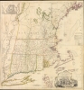
Title
A MAP of the most INHABITED part of NEW ENGLAND, containing the PROVINCES of MASSACHUSETS BAY and NEW HAMPSHIRE, with the COLONIES of KONEKTIKUT AND RHODE ISLAND. Divided into Counties and Townships: The whole composed of Actual Surveys and its situation adjusted by ASTRONOMICAL OBSERVATIONS.
1755 (dated)
42.25 x 40 in (107.315 x 101.6 cm)
1 : 440000
Description
This is the rare 1755 first state of Braddock Mead's French and Indian War Era map of New England - one of the most significant and iconic America maps ever produced. It was one of the first large-format regional maps of any part of North America and was the most comprehensively researched and detailed map of contemporary New England.
This map is admired by collectors, curators, and experts alike for its precision, geopolitical significance, and beauty. It stands alongside two other fundamental maps also published in 1755: John Mitchell's A Map of British and French Dominions in North America and Lewis Evans's A General Map of the Middle British Colonies, in America.
Remarkably, some of the events depicted on the map were just one month old at the time of publication, demonstrating a dynamic era in which military reports and plans traveled from the battlefield to eastern ports, across the Atlantic by ship, and on to London to be engraved with incredible speed.
Context and Scope
The map depicts a stretch of coastline spanning from the Damariscotta River in the north to Long Island and the Hudson River delta in the south. It reflects the best state of knowledge at the time. It was issued in 1755, at the height of British colonial rule and the initial stages of the French and Indian War (1754 - 1763).This masterwork encapsulates the prowess of British power in North America prior to the Revolution. It was crucially influential in how its audience in Great Britain perceived the American colonies and made a powerful claim to further British territorial interests on the continent. What we know now, but few understood at the time, is that the map reflected both the height of Britain's American empire and the cusp of its collapse.Identifying the First State
The best-known element to look for when identifying the first state of this iconic map is the spelling of Connecticut with a 'K' (Konnektikut). Events of the 1750s in North America occurred at such a rapid pace that a revised version was soon necessary, and a second state was published only four years after the first. On this 1759 second state, Connecticut is written with a 'C' (Conecticut).
The landscape around the Hudson River and Lake George has also changed significantly from the first to the second state. In the second state, a postal road runs along the western bank of the Hudson until it crosses the river at the new Fort Edward, from where it deviates north to Lake George. To guard this road, a string of new forts flank the river. Further encampments like Fort Ann appear to have been abandoned or omitted. Even the outline of Lake George itself varies dramatically in the first and second states. One of the reasons that this first state is so desirable is because it includes so many historical subtleties and details omitted from later states and editions.The Crown Point Campaign
While differences between the first two states may seem obscure, scholars understand that they are an essential reflection of different points during the French and Indian War. Nowhere is this case more evident than the documentation of the Crown Point Campaign, which is dramatically mapped on our map but lacking on the second state. The campaign featured the first major hero of the war, General William Johnson, who led a force of four thousand men recruited from Massachusetts, Connecticut, New Hampshire, Rhode Island, and New York. He was charged with attacking the French stronghold at Crown Point, Fort Frederik, from which the French controlled Lake Champlain and launched incursions into what the British considered their territory.
Johnson's second in command led the first division up the Hudson River starting in mid-July, 1755. They built or refurbished a series of forts and storehouses along the river, including Fort Hardy at Saratoga (depicted but not named on the map), 'Lidius or Nicholson's Fort' (today known as Fort Miller), and Fort Lyman, a log fort that was shortly thereafter renamed Fort Edward. The latter two forts were both located at strategic portages connected to the Hudson: carrying places indicated on the map link Fort Miller to Fort Ann on the banks of Wood Creek, and Fort Lyman to Lac Saint Sacrement (Schwartz 1994: 59-60).
In mid-August, Johnson set out across the route from Fort Lyman and camped on the southern shore of Lac Saint Sacrement with about two thousand men. He renamed it Lake George in honor of his king. His plan was to sail down it to Ticonderoga and then proceed to attack Fort Frederik. He also began construction of a new fort, Fort Henry, on the southern shore of the lake. In response, the French commander, Marshal Ludwig August Dieskau, reinforced both Fort Frederik and ordered construction of a new fort on the promontory at Ticonderoga, Fort Carillon. Our map depicts these locations as camps; the second state shows them as completed forts.
On September 5th, Dieskau led a small force up Wood Creek with the intention of marching on Fort Lyman. When he learned from a prisoner that the British were already camped at the lake, he devised an ambush and attacked. This attack was the first phase of the Battle of Lake George and is marked on our map with a battleground symbol that carries the date September 7th, 1755, just two months before the publication of our map. The English suffered heavy losses and retreated to their encampment, which had been turned into a makeshift defensive position using trees and overturned wagons (Schwartz 1994: 59-60). Johnson was then able to lead a successful counterattack, forcing a French retreat.
The Battle of Lake George turned out to be one of the instigating factors accelerating the French and Indian War, which broke out in full the following year. General Johnson's victory over the French sparked massive public interest in the American colonies and their frontiers. For the savvy publisher with the right platform and product, this interest could be translated directly into sales. Only one month had passed from the formal announcement of the British victory at Lake George to the publication of Mead's map. The inclusion of a detailed plan of Fort Frederik and the mapping of key places related to the battle thus spoke directly to the growing public interest in the American theatre of war. It also underscored just how accurate and up-to-date this map was.
The second state omits General Johnson's camp and the French camps, as well as the battlefield marker and date. By the time of its publication in 1759, events of the intervening four years had clearly shifted the situation at Lake George. The siege of Fort Henry in 1757 and the Battle of Carillon at Ticonderoga in 1758 were both major French victories. The mapmakers thus no longer sought to highlight the area, intent as they were on promoting British interests.A Cornerstone Map for New England
This map represents the early formative period of America: before the American Revolutionary War (1775 - 1783) but well after generations of settlement had established firm regional identities. Within the densely settled regions along the coast, the variegated status of what would soon become the individual States stands out clearly. While Massachusetts and New Hampshire are denoted as provinces, 'Konnektikut' and Rhode Island are identified as colonies, whereas southern Rhode Island is recorded as Providence Plantation. Yet despite these differences in status, the regional borders are drawn clearly in these areas, denoting a well-established consensus on the subdivision of land. Further inland, however, the consensus lessens, so much so that some borders are deliberately omitted (e.g. between New Hampshire and New York). These issues had not yet been worked out at this stage.The Oblong
The fluidity of colonial borders in the first half of the 18th century is attested by the boundary between Connecticut and New York. A line of text reads: 'The Land inclosed between the double Boundary Lines is the Oblong of 69,000 Acres granted by Konekticut to New York.' This refers to an agreement between the two colonies in which New York was granted a strip of land, known as the 'Oblong,' in exchange for the previously granted Connecticut panhandle. After a final survey, Connecticut formally signed the Oblong in May of 1731, ending a long-standing territorial dispute.Indigenous Encounters
Conflict with Indigenous peoples is evident from the map's annotations, which set frontier lines between settlers and Native American tribes. For example, south of Sunape Pond, two rows of land plots are labeled: 'A double Line of Towns for a Frontier against Indians.' Beyond these lines is the wilderness, though this too belongs to the Crown, as an inscription between Lake George and Sunape Pond will have us understand: 'Wilderness Lands of the Crown not yet appropriated.'French Encroachers
However, the real enemies in this dramatic depiction are the French encroachers, who, despite being appreciably outnumbered in population, were expanding their territories and catchment areas through alliances with native tribes. Several French settlements are accompanied by the descriptor 'a French Incroachment.' Fort Frederik is most prominent at the southern tip of Lake Iroquois (just north of Ticonderoga). Even though the fort is marked on the main map, it was deemed worthy of a detailed insert following the British-French battle at Lake George. Located in the chart's upper left corner, this is one of only two insets on the map, the other being a detailed plan of Boston Harbor. The apparent discrepancy in importance between the most important Atlantic port in New England and a relatively obscure French fortress in the interior wilderness speaks volumes as to the commercial aims of this map as a politicized, if not political, document.Boston Harber
The inset of Boston Harbor includes all the islands and shoals, as well as the many smaller ports frequented in the bay. The need for this inset is obvious: despite being the largest port in New England, access was not straightforward, and navigating the bay required both skill and local knowledge. Consequently, Mead used the fourth book of the premier navigational atlas The English Pilot (1706) as his starting point for depicting Boston Harbor. His inset included a substantial number of soundings and is headed by a caption that stresses reliability: A Plan of Boston Harbor from an Accurate Survey.A Famous Cartouche
There is no doubt that this map was a showpiece: a visually impressive opus meant to captivate imaginations and inspire awe. The map has a consistent and rather crisp aesthetic, but nowhere are the artistic ambitions more apparent than in the allegorical cartouche that dominates the bottom of the map. One scholar remarks that the artistry of the cartouche marks maps such as this as '…furniture, not residents of library shelves' (Edney 2003: 162). Framed by swirling arabesques and crowned by the map's lengthy title, the central image is of William Bradford and the Pilgrims arriving in America. With the Mayflower proudly anchored in the bay, we see the European Pilgrims engage with the local population, who present the newcomers with desirable pelts. As if to ensure that there was no doubt what this image depicted, the group is flanked by a large rock marked 'Plymouth MDCXX'.
The cartouche was most likely an addendum by Thomas Jefferys, the map's publisher and a skilled engraver. It is an important compositional element as it visualizes two central British claims. First, there is the recognition that comes with being first. As the Mayflower settlers were English, the Crown felt it could legitimately lay claim to the entire territory of New England. French 'encroachments' were, in other words, both immoral and unlawful. The inclusion of the pelts in the image makes the Crown's interest in her colonies quite explicit: colonies were primarily a locus for lucrative trade.The second aim lies in the juxtaposition of the Mayflower's arrival with the exceptional detail of the map. This composition captures the impressive development that New England had undergone since the landing at Plymouth Rock. As if to say, not only did we come first, but we have been diligent and dutiful in building up this land, and so it must be ours. This elegant yet plain symbolism is emblematic of the artistic genius that pervades the Jefferys maps compiled by Mead.The Missing Reference
Mead drew directly on Dr. William Douglass' Plan of the British Dominions of New England in North America, also published in London in 1755. When Douglass died in 1752, the publication of his map was left to his nephew. He saw the potential for commercial success in his uncle's map and immediately sought to have it published. It would take three years to bring to fruition and never made much of a splash, but Douglass had compiled a chart unlike any map of New England previously executed. Mead knew this, and even though both maps came out the same year, he had been aware of Douglass's work for some time.
The exact degree and nature of Mead's access to Douglass' data remain obscure. Still, both men were highly active in cartographic circles, where findings were compared and manuscript maps shared. Douglass spent many years accumulating and compiling his data, often in a public manner, and Mead followed his progress carefully. Douglass was keenly interested in promulgating New England's distinctiveness from the other American colonies and tried to incorporate this distinctiveness into his map. This suddenly became an ideal template for Mead to work from in the context of rising tensions over the American colonies.
The omission of Douglass from the list of sources is indeed suspect. Even though Mead's map is hardly a copy of Douglass's, it does rather disingenuously misrepresent its sources by citing a non-extant source for Connecticut instead of Douglass' map, which was used (Edney 2003: 159). That said, Mead significantly improved the map, for example, by including county lines, updating toponyms, and adding essential cartographic elements such as a graticule of latitude and longitude. He also expanded the map's scope to include frontier territories in the northwest and upstate New York. In doing so, he crafted a dramatic image of the theatre of the French-Indian War: a visualization that resonated deeply with British audiences and made the map a huge commercial success.Publication History and Census
This map was compiled by Braddock Mead (aka John Green) for engraver and publisher Thomas Jefferys. It was published in London on November 29th, 1755, as a separately issued engraving on four sheets.
As mentioned, Jefferys published a second state in 1759. The map was then extensively altered and re-engraved for a new edition, published by Jefferys in his 1768 atlas General Topography of North America. It immediately became the standard reference for mapmakers, soldiers, and statesmen alike and was reissued repeatedly well into the 1790s.
Examples of this 1755 edition are found in the British Library, the Library of Congress, the Newberry Library, the William Clements Library, the Osher Map Library, and the Sächsische Landesbibliothek-Staats-und Universitätsbibliothek Dresden. On the private market, it is a holy grail item and, save for this example, historically unobtainable.
CartographerS
Braddock Mead (c. 1688 - 1757), also known as John Green, was an Irish cartographer and map engraver active in London during the middle part of the 18th century. Mead is one of the most interesting and colorful figures in cartography whose louche personal life sharply contrasted with the high standard of his maps. Mead was born in Ireland around 1688 and seems to have come from a good family and received a respectable education. His brother Thomas Mead held the position of Lord Mayor of Dublin in 1757. Braddock Mead left Dublin for London around 1717 where he plunged into vice, subsidizing his cartographic work with hack work and gambling. In 1728 Mead fell in with a plot to defraud a 12 year old Irish heiress, Bridget Reading, of her fortune by kidnapping and marrying her himself. Mead suffered jail time for the crime but was more fortunate than his partner, a fellow Irishman named Kimberly, who was hanged. As a cartographer Mead cannot have exhibited a more antithetical character. He held himself and others to the highest standards of accuracy and scholarship, and issued a call for greater transparency in the field of mapmaking. Mead worked with Ephraim Chambers on the Universal Dictionary, as well as with Cave and Astley in the publication of various travelogues and explorer's journals, notably Astley’s New General Collection of voyages and travels. Eventually he came to work for the publishing house of Thomas Jefferys, who saw through Mead's personal failings to appreciate his cartographic brilliance. Mead has been called the genius behind Jefferys and he seems to have had a hand in the production of many of Jefferys' most important maps. William Cumming notes that Mead
had a number of marked characteristics as a cartographer ... One was his ability to collect, to analyze the value of, and to use a wide variety of sources; these he acknowledged scrupulously on the maps he designed and even more fully in accompanying remarks. Another outstanding characteristic was his intelligent compilation and careful evaluation of reports on latitudes and longitudes used in the construction of his maps, which he also entered in tables on the face of the maps ... Mead's contributions to cartography stand out ... At a time when the quality and the ethics of map production were at a low ebb in England, he vigorously urged and practiced the highest standards; in the making of maps and navigational charts he was in advance of his time. For this he deserves due credit.
More by this mapmaker...
Thomas Jefferys (1695 - November 20, 1771) was one of the most prominent and prolific map publishers and engravers of his day. Jefferys was born in Birmingham and was apprenticed to the engraver Emmanuel Bowen in 1735. Later, in the 1740s he engraved several maps for the popular periodical Gentleman's Magazine. Around 1740 Jefferys was finally able to go into business for himself and in 1746 received an appointment as 'Geographer to Fredrick, Prince of Wales,' which shortly after translated to the position of 'Royal Cartographer to King George III.' Jefferys initially specialized in compiling and re-engraving the works of earlier cartographers into more coherent cartographic wholes. Later, while not salaried position, Jefferys' appointment as 'Royal Cartographer' guaranteed preferential access to the most up to date cartographic material available, allowing him to produce new and updated charts of exceptional accuracy. He his best known for his maps of the Americas, particularly the posthumously published 1775 American Atlas, which included some of the finest and most important late colonial era maps of America ever made. Despite his prolific publishing history, royal appointments, and international publishing fame, Jefferys lived most of his life in dire economic straits. He was bailed out of bankruptcy by Robert Sayer during the production of the American Atlas. In the end, Jefferys died suddenly with very little to his name. Nonetheless, his cartographic legacy survived, and even after his death in 1771, many of his important maps continued to be published and republished by Sayer and Bennet, Conrad Lotter, Georges Louis Le Rouge, Laurie and Whittle, and others. Many attribute some of Jefferys best maps to the colorful and criminally inclined Irish cartographic genius Braddock Mead (John Green, c. 1688 - 1757), who is considered the 'secret behind Jefferys.' Jefferys was succeeded by his son, also Thomas, who had little success as a cartographer and eventually partnered with, then sold his stock and plates to William Faden - Jefferys' true heir. Learn More...
Condition
Very good. Strong margins. Original outline color, lightly refreshed. Backed on archival tissue for support, small marginal chips repaired with minute areas of reinstatement.
References
OCLC 945088737 (Clements Library and BnF). LOC #G3720 1755.J4. Crone, G. R., 'John Green. Notes of a Neglected Eighteenth Century Geographer', Imago Mundi, 6: 85-91. Crone, G. R., 'Further Notes on Braddock Mead, alias John Green, an Eighteenth Century Cartographer', Imago Mundi, 8: 69-70. Cumming, W. P., British Maps of Colonial America, (University of Chicago Press: Chicago). M.H. Edney, M. H., 'New England Mapped: The Creation of a Colonial Territory', Cartografia europea tra primo Rinascimento e fine dell'illuminismo: atti del Convegno, L.S. Olschki (ed.). Schwartz, S. I., The French and Indian War 1754-1763: the Imperial Struggle for North America.