Title
Geological Map of the Mother Lode Belt in El Dorado and Amador Counties, California.
1897 (dated)
18 x 53 in (45.72 x 134.62 cm)
1 : 63360
Description
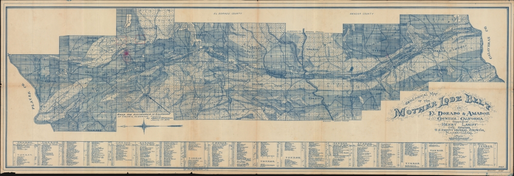
This is a stunning large-scale 1897 diazo-print Henry Lahiff map of the Mother Lode Belt, in California's Amador and El Dorado Counties. This map details the most abundant gold-producing region in California during the latter years of the Gold Rush.
A Closer Look
The reverse cyanotype map is oriented to the east, with north at left. It is bounded by Placer County and the Middle Fork of the American River on the north (at left), and the Mokelumne River on the south (right), and illustrates an east-west belt roughly 8 miles wide. The whole is sectionalized into half-inch squares. Geological zones are illustrated and labeled. Several hundred mines in various zones are numerically coded to a table at the map's base. Several squares at top left, near Nelson and Rock Creeks, are highlighted in red manuscript, likely referencing an unnamed claim.The Mother Lode
The Mother Lode refers to the auriferous slate belt on the western flank of California's Sierra Nevada Mountains. Roughly 70 miles wide and 250 miles long, the Mother Lode embraces parts of Mariposa, Tuolumne, Calaveras, Amador, and El Dorado Counties. It is so named as it was the 'mother' source of the alluvial gold deposits discovered in the Sacramento Valley in the early stages of the California Gold Rush. The deposits, primarily quartzite ore, were rich enough to be a global wonder, leading this map to be reprinted for the Mineral Exhibit at the 1900 Paris Exposition. The Mother Lode Belt was the primary source of gold in California, drawing thousands of prospectors in search of fortune. The exploitation of these rich deposits played a pivotal role in California's development, leading to explosive population growth, the establishment of overnight boom towns, and contributed to the state's early prosperity and integration into the United States.The California Gold Rush
The discovery of gold at John Sutter's mill by James Wilson Marshall (1810 - 1885) in January of 1848 was one of the most definitive moments in American history. Coming at the end of the Mexican-American War (1846 - 1848), the timing of the discovery could not have been more propitious. The combination of new seemingly unlimited territory and the lure of gold led to a stampede of adventurers, prospectors, merchants, and homesteaders eager for a new life on the frontier. The Gold Rush was not limited to Americans crossing the Great Plains. European, Australian, and even Chinese immigrants rushed into California hungry for their part of the great strike. This Great Migration transformed the United States in just a few years from a former colony into an expansive transcontinental nation on the cusp of becoming a world power.Diazo Print or Whiteprint
The diazo print (whiteprint or diazo for short) is a photo reproductive technique best understood as a reverse cyanotype or blueprint. The process yields distinctive blue lines on white paper. Like cyanotypes, the diazo process gained popularity in architecture circles, where it was a simple and effective way to duplicate documents in the field. The earliest diazotypes appeared around 1880 and were adopted for military and field cartographic use from about 1895. The diazo process was commercialized in 1923, when the German firm Kalle and Company developed Ozalid, a patented diazo paper that made diazotyping even easier. By the 1950s, it supplemented cyanotypes as the reprographic technique of choice for technical drawings.Publication History and Census
This map has a complex publication history, not the least of which is because of the variants issued thus as short-run diazo prints. It was first issued in the '13th Report State Mining Bureau', although we see no examples of the map in surviving copies of that work, surmising it may have been more of a supplement than an insert. In 1900, a version was issued in 100,000 copies for the Mineral Exhibit of the Southern Pacific Railroad Company's Department of the French Exposition - that variant was lithographed in San Francisco by Louis Roesch and features a descriptive right panel. There are several diazo variants, as here, with no two alike. The present example has a manuscript note, 'Revised 1935', but no indication of revisions, leading us to believe this cyanotype is off the 1897 first issue. We see other similar variants, with marginally different content, with 1934 and 1935 manuscript revision dates. The Roesch example is the most common, and we see it in 11 institutions. Diazo examples, as here, appear in 2 institutional collections.
Cartographer
Henry Lahiff (April 24, 1868 - February 7, 1954) was an Irish-American civil engineer active in California in the late 19th and early 20th centuries. Lahiff was born in Gort, Galway, Ireland and emigrated to the United States in 1888, taking citizenship in 1902. He initially settled in Brisbee, Arizona, where he found work with a mining company. Soon after he relocated to Placerville, where he found employment as the U.S. Deputy Mineral Surveyor. He died in Sacramento in 1954. More by this mapmaker...
Condition
Very good. Diazo print. Some margin wear. Toning. Wear and minor verso reinforcement at a few fold intersections.
References
OCLC 21754214. UCLA 9920463633606533.