This is a rare c. 1826 separate German issue of François Bulla's seminal comparative mountains and rivers chart.
A Closer Look
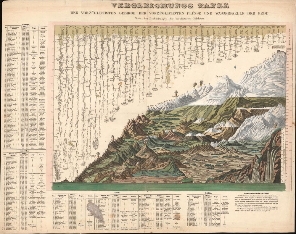
While a fresh engraving, this map is otherwise an issue of François Bulla's 1826 mountains and rivers chart, one of the first charts to integrate mountains and rivers on a single chart and the first to add waterfalls. For a long time, this map was considered by scholars to be the earliest known chart to consolidate comparative mountains and rivers charts into a single sheet. Today, that honor has been superseded by the 1823 William Darton chart. As a comparative chart, Bulla's chart is far more sophisticated than Darton's earlier chart, incorporating a larger format, significant additional information, and comparative waterfalls.Mountains so High
The comparative mountains section, occupying the lower right half of this chart, details the principal mountains of the world. Ranges are color-coded to show vegetation zones. The elevations of important cities, including Paris, Rome, London, Geneva, Mexico, Bogota, and Quito, among others, are noted. There are also extensive notations on vegetation, volcanic activity, and lichen, much of which is no doubt influenced by Alexander von Humboldt. The Himalayan peak Dhaulagiri is identified as the world's greatest mountain. Also noted are the ballooning feats of Frenchman Gay-Lussac, who attained an altitude of 23,000 feet in 1808, and the Italian meteorologist Pascal Andreoli and Carlo Brioschi, who rose to 27,000 feet over Padua, also in 1808.Rivers so Long
The upper left portion of this chart is dominated by the world's greatest rivers. Bulla attempts not only to express the lengths of the various rivers, but also details regarding their course and sources. Along each river, important lakes, cities, directions, and distance measurements are noted. Here the Amazon is identified as the world's greatest river, followed by the Mississippi. The Nile comes up a sad sixth, although admittedly, it had yet to be fully explored.And Waterfalls
This is the first appearance of waterfalls on a comparative mountains and rivers chart. As the great waterfalls of South America and Africa remained as yet largely unknown in European intellectual circles, most of the focus is on European waterfalls with the Chute de Gavarnie identified as the world's greatest cascade.Publication History and Census
This is theonly known example of the present chart. It is not cataloged in OCLC, and no printer or engraver is named. The only reference to this map is an 1879 catalog entry from the Vereins für Geschichte und Landeskunde von Osnabrück.
Cartographer
François Bulla (fl. c. 1814 - 1855) was a French engraver, printmaker, lithographer, and printer. Born in Tessin, Bulla opened his business at 98, Rue du Temple around 1814 and moved to 38, Rue Saint-Jacques in 1821. Bulla published a catalog of his work in 1838 entitled Catalogue général des estampes et lithographies compost le fond de F. Bulla, éditeur, quaint Saint-Michel, 25 that was printed by the Imprimerie de Ducessois. Bulla's business was described in the Bazar Parisien in 1826 in this manner:
Possesses a considerable stock of prints in all formats. A print of Girodet's painting La bataille de la révolte du Caire stands out, along with allegorical and historical prints, as well as prints illustrating religious subjects. He accompanies these with a series of beautifully executed landscapes.
The firm moved to Rome in 1840, establishing itself at 2 Via del Vantaggio not far from the Piazza del Popolo. In 1848, Bulla entered into a short-lived partnership with Cereghetti; he then moved on to a partnership with Stampa, a Spanish editor, in 1849. Bulla retired in 1855. Bulla had five sons: Eugène (known as Bulla ainé), Joseph, Antoine, Laurent, and Jean-Baptiste. All five of his sons would adopt their father's profession and become either editors or printers. His two oldest sons established their own firms. Antoine was sent by his father to Cadiz in 1849, but when François retired in 1855, Antoine took over his father's share of the partnership with Stampa. The firm still operates to this day in Rome, Italy and is owned by Bulla's descendants.
More by this mapmaker...
Good. Some foxing. Discoloration in lower tables.