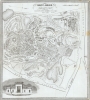
This is an 1845 Nathaniel Dearborn map of Mount Auburn Cemetery, Watertown, Massachusetts. When this map was issued, Mount Auburn Cemetery was among the most visited destinations in the United States, celebrated as the first garden cemetery in the country.
A Closer Look
The map depicts Mount Auburn Cemetery. Individual gravesites are illustrated and numbered; however, the accompanying index is not present. (Intriguingly, even the New York Public Library's Bulletin from 1963 states that the example that they had at the time did not have an index.) Roads and paths throughout the cemetery are indicated. A view of the cemetery's Egyptian Revival main gate adorns the bottom left.Mount Auburn Cemetery
Located in Cambridge and Watertown, Massachusetts, Mount Auburn Cemetery is considered the first rural or garden cemetery in the United States. In addition to being a cemetery, the rolling hills double as a botanical garden. The 174-acre cemetery was designed by Henry Alexander Scammell Dearborn. Enthusiasm over Mount Auburn is credited with jump-starting the public parks and gardens movement. Mount Auburn Cemetery was one of the most popular tourist destinations in the country in the 1840s, with 60,000 people visiting in 1848. Today, Mount Auburn Cemetery boasts a collection of over 5,500 trees of nearly 700 species and varieties.Publication History and Census
This map was created and published by Nathaniel Dearborn in 1845. We note three examples of the present edition in OCLC, which are part of the collections at Yale University, the American Antiquarian Society, and Harvard University. The map was first published in 1839.
Cartographer
Nathaniel Dearborn (1786 - November 7, 1852) was a New England engraver and publisher based in Boston during the first half of the 19th century. Dearborn was born in New England in 1786 to inventor Benjamin Dearborn; his siblings included John M. Dearborn and Fanny Dearborn Hanman. In Boston he learned engraving from Abel Bowen. By 1814 Dearborn had printing and engraving offices on School Street; later moving to Market Street (ca.1823), State Street (ca.1826-1831) and Washington Street (ca.1832-1852). Dearborn died November 7, 1852, in South Reading. His son, Nathaniel S. Dearborn, continued as an engraver and printer in Boston, working on Water Street (ca.1847-1851) and School Street (ca.1857-1868). N.S. Dearborn exhibited several printed specimens in the 1850 exhibition of the Massachusetts Charitable Mechanic Association. His grandson S.B. Dearborn also worked as a printer. More by this mapmaker...
Very good. Light wear along original fold lines. Verso repairs to fold separations. Reinforced where previously attached to binder. Very light soiling. Accompanied by original binder. Catalogue of Proprietors and Tombs not present.
OCLC 56714610.