1932 Gillespie Pictorial Map of the Mount Hood Loop, Oregon
MountHoodLoop-gillespie-1932$1,500.00

Title
Mount Hood Loop Oregon.
1932 (undated) 20 x 14.5 in (50.8 x 36.83 cm)
1932 (undated) 20 x 14.5 in (50.8 x 36.83 cm)
Description
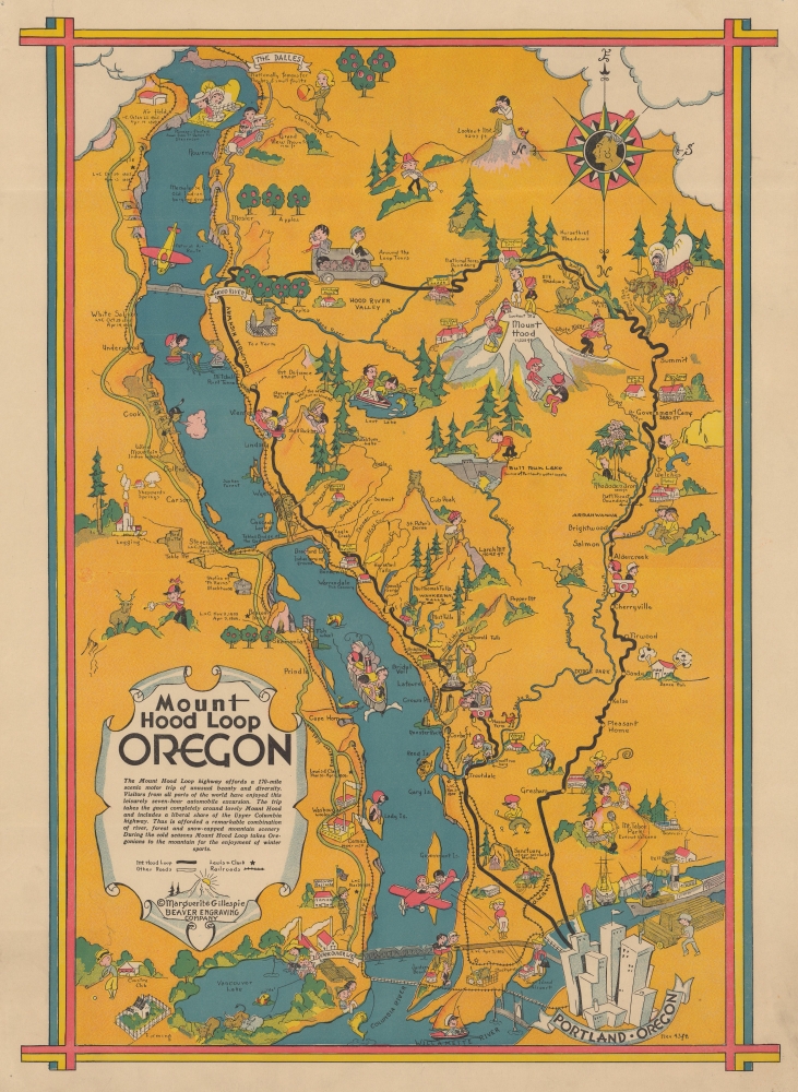
This is a 1932 Marguerite Gillespie pictorial map of the Mount Hood Scenic Loop in Oregon. The Mount Hood Scenic Loop takes travelers over 290 miles through western Oregon, including a section of the historic Columbia River Highway.
A Closer Look
Oriented toward the east, the map depicts a stretch of the Columbia River from The Dalles to Portland. Mount Hood appears to the right of the river. Tourists and Oregonians appear throughout the region, driving, hiking, and generally exploring the area. Several people appear on Mount Hood: two at the top taking in the view, one skier, one tobogganer, and a pair of hikers. Towns are identified along the loop, along with parks, mountains, rivers, and even a handful of inns and lodges. Airplanes and steamships highlight other forms of modern travel. Mills, canneries, and even a fish hatchery are illustrated, and lumber is stacked along the riverfront in Portland.20th Century Pictorial Cartography
Pictorial qualities have been common in cartography from at least the 16th century when publishers like Braun and Hogenberg incorporated view-like qualities and other pictorial elements into their famous city plans. Braun and Hogenberg, and similar cartographers, issued their town books to express not necessarily the geography of their subjects but rather the 'essence' of the town/city. As mathematics and surveying principles advanced, travel increased, and the ability to translate two-dimensional cartographic perspectives into an understanding of the actual world became commonplace, maps themselves transformed. This trend is a recognizable progression that evolved cartographic conventions from the 17th to the 19th centuries. By the late 19th century, most maps had become geographical tools that illustrated the region cartographically but failed in the original raison d'être, as expressed by Braun and Hogenberg, to illustrate a place's 'essence.' So, where a city map of 19th-century Paris might provide a completely navigable presentation of the city, one could glean almost nothing of Paris' character from it. In the late 18th century, the first modern 'pictorial' style maps developed. These maps, like Tomas Lopez's 1788 map of Seville, attempted to provide both cartographic accuracy and pictorial elements that might convey the city's character. In that case, Lopez incorporated pictorial vignettes to illustrate important buildings and monuments. This style became increasingly common throughout the 19th and early 20th centuries, particularly for centers of commerce like London, Paris, and Rome, where they were often mass-produced and referred to as 'monumental' maps. The style further evolved in the early to mid-20th century, when revolutionary cartographers and illustrators like MacDonald Gill, Jo Mora, Frank Dorn, Ernest Dudley Chase, and many others combined vignette style illustrations, modern printing techniques, and inspiration from Japanese printmaking and manga and clever satirical cartographers/artists like Fred Rose, to produce maps that once again focused on revealing the essence a place, usually, but not always, at the sacrifice of cartographic precision.Publication History and Census
This map was drawn by Marguerite Gillespie for The Sunday Oregonian, originally published on the front page of one of their editions and later published as a separate issue due its popularity. The present example is one of the separate issues. We note a single example cataloged in OCLC, at Yale University.Cartographer
Marguerite L. Gillespie (1892 - October 16, 1976) was a commercial artist active in Portland, Oregon, from the early 1930s through at least the mid-1940s. She created several pictorial maps for The Sunday Oregonian, many of which were then sold as separate issues due to their popularity. In the 1930s Gillespie worked for the Beaver Engraving Company, which was founded in 1909 in Portland and still operates today. More by this mapmaker...
Condition
Very good. Pinholing in corners. Closed tear extending 1/2 inch into border in upper left corner professionally repaired on verso.
References
OCLC 54655968.