This item has been sold, but you can get on the Waitlist to be notified if another example becomes available, or purchase a digital scan.
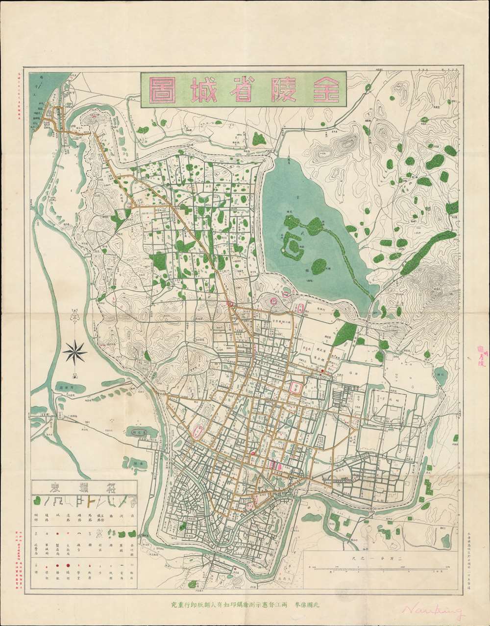
1907 Qing Chinese Map of Nanjing, China w/ western survey
NanjingQing-nanyanglandsurvey-1907
Title
1907 (dated) 27.5 x 21.5 in (69.85 x 54.61 cm) 1 : 20000
Description
Building a Modern City
This was a period of rapid development and modernization in Nanjing - part of Qing efforts to modernize China. The cartography here was developed in a series of official surveys conducted between 1894 and 1907. This is essentially a zoning map, offering meticulous detail throughout, noting all roads, their grade, and if they are under construction. It also notes schools, bridges, playgrounds, tax authorities, police, hospitals, and more. From the distribution of streets and buildings, we can see that the political, commercial, and cultural centers at that time were mainly concentrated in the south of the city, especially in the areas of Shengzhou Road, Qinhuai River, and Confucius Temple. The current road from Xinjiekou to Gulou had already been developed. There are more than ten east-west roads and seven intersecting north-south trunk roads. The port, appearing in the upper left on part of the Yangtze River, is evidence of bustling international trade.Effort to Modernize Map Publishing
The multi-color chromolithographic printing gives evidence to the sophisticated western-style reprographic techniques then available to the Qing government of Nanjing. Work of this caliber was uncommon outside of the foreign Concessions in pre-war China, and rarely used by the Qing administration. It is the product of the Nanyang Land Survey Department (南洋陸地測量司 / NLSD), established one year earlier in 1906, and the Liangjiang Surveying and Mapping School (两江测绘学堂 / LSMS), established two years earlier in 1905. The LSMS contracted Japanese surveyors and printers to teach at the school, which in a short time, produced more than 200 skilled Chinese mapmakers. Issued one year after the founding of the NLSD, this map is built upon the stylistic conventions of Japanese civil cartography of the late Meiji Era.Chromolithography
Chromolithography is a color lithographic technique developed in the mid-19th century. The process involved using multiple lithographic stones, one for each color, to yield a rich composite effect. Oftentimes, the process would start with a black basecoat upon which subsequent colors were layered. Some chromolithographs used 30 or more separate lithographic stones to achieve the desired effect. Chromolithograph color could also be effectively blended for even more dramatic results. The process became extremely popular in the late 19th and early 20th centuries, when it emerged as the dominate method of color printing. The vivid color chromolithography produced made it exceptionally effective for advertising and propaganda imagery.Publication History and Census
This map was printed in August of Guangxu 33, or 1907, in Nanjing, China, and issued by the Nanyang Land Survey Department (南洋陸地測量司). It was distributed by the Nanyang Military Library (南洋軍用圖書館) for official use. We are aware of no other known examples. This map does not appear in the OCLC, but there are some vague references to a map of the same title in the Nanjing Library.Cartographer
Nanyang Land Survey Department (南洋陸地測量司; 1906 - 1928), NLSD for short, was a military survey and mapping office and school created in Nanjing, China, in Guangxu 32 or 1906. The service was attached to the Liangjiang Surveying and Mapping School (两江测绘学堂), attached to the Daxing Palace, which itself was established one year earlier in 1905. The school's aim was to modernize Qing mapping technology, incorporating western printing and surveying technology. The Qing administrators invited Japanese printers and mapmakers to Nanjing, where they taught triangulation, topographic mapping, and cartographic printing. They also facilitated the acquisition of western lithographic presses, and measuring tools. The NLSD remained active until 1928, Minguo 17, when surveying and mapping services were folded into a larger national agency. More by this mapmaker...

