This copy is copyright protected.
Copyright © 2025 Geographicus Rare Antique Maps
Digital Image: 1876 Hills-Disturnell City Map or Plan of New York City
NewYork-disturnell-1876_d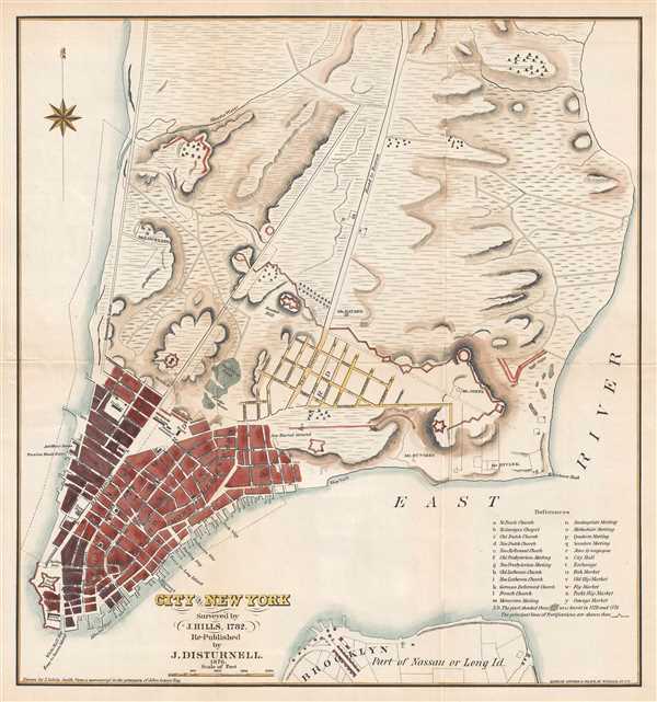

FOR THE ORIGINAL ANTIQUE MAP, WITH HISTORICAL ANALYSIS, CLICK HERE.
Digital Map Information
Geographicus maintains an archive of high-resolution rare map scans. We scan our maps at 300 DPI or higher, with newer images being 600 DPI, (either TIFF or JPEG, depending on when the scan was done) which is most cases in suitable for enlargement and printing.
Delivery
Once you purchase our digital scan service, you will receive a download link via email - usually within seconds. Digital orders are delivered as ZIP files, an industry standard file compression protocol that any computer should be able to unpack. Some of our files are very large, and can take some time to download. Most files are saved into your computer's 'Downloads' folder. All delivery is electronic. No physical product is shipped.
Credit and Scope of Use
You can use your digial image any way you want! Our digital images are unrestricted by copyright and can be used, modified, and published freely. The textual description that accompanies the original antique map is not included in the sale of digital images and remains protected by copyright. That said, we put significant care and effort into scanning and editing these maps, and we’d appreciate a credit when possible. Should you wish to credit us, please use the following credit line:
Courtesy of Geographicus Rare Antique Maps (http://www.geographicus.com).
How Large Can I Print?
In general, at 300 DPI, you should at least be able to double the size of the actual image, more so with our 600 DPI images. So, if the original was 10 x 12 inches, you can print at 20 x 24 inches, without quality loss. If your display requirements can accommodate some loss in image quality, you can make it even larger. That being said, no quality of scan will allow you to blow up at 10 x 12 inch map to wall size without significant quality loss. For more information, it is best consult a printer or reprographics specialist.
Refunds
If the high resolution image you ordered is unavailable, we will fully refund your purchase. Otherwise, digital images scans are a service, not a tangible product, and cannot be returned or refunded once the download link is used.
John Disturnell (1801-1877) was a New York book and map publisher operating gin the early to middle 19th century. Disturnell worked with various engravers and cartographers over the years including Calvin Smith, J. H. Young, and G. E. Sherman as well as the Ensign, Bridgeman and Fanning group. His primary focus seems to have been New York and vicinity, however, his most significant contribution to U.S. history came from the opposite side of the continent. When Nicholas P. Trist was sent to Mexico to negotiate the 1847 Treaty of Guadeloupe Hidalgo which defined the Mexican-American border at the end of the Mexican-American War, he carried with him Disturnell's Map of America. This map, among other inaccuracies, located El Paso a whopping 34 miles north and 100 miles east of its true location. Since Trist based the border treaty on mileages from El Paso, the obvious subsequent confusion lead to the conflicts that were to follow. The border problems between the United States and Mexico that resulted from this error were not resolved until 1963. More by this mapmaker...
John Calvin Smith (1809 – June 11, 1890) was an American surveyor and geographer active in New York during the middle part of the 19th century. He was a charter member of the American Geographical and Statistical Society (American Geographical Society). He worked with other important New York cartographers including John Disturnell, George Sherman, and Samuel Stiles, with whom he often published under the Stiles, Sherman & Smith imprint. Stiles may have introduced Smith to J. H. Colton, who acquired many of his map plates in 1853. Most of Smith's maps focus on New York counties, but he also issued maps of the United States, Illinois, Texas, and the California gold fields. Despite being an important and prolific cartographer, much of his personal life and history are shrouded in mystery. Learn More...
Snyder and Black (1845 - c.1968) was a publishing firm based in New York City. It began publishing maps as early as 1845 from their offices at 87 Fulton Street. By 1876, the company had moved its operations to 92 William Street in New York, and would later buy a building at 200 William Street. The New York Department of Commerce honored Snyder and Black in 1952 along with over 250 other companies that had been in New York since their founding. Snyder and Black was mentioned often in the New York Times Advertising column as a point-of-sale specialist between 1947 and 1968. By March 1960, however, the company is referred to by the New York Times in that same Advertising column as Snyder and Black and Schlegel. Learn More...
Copyright © 2025 Geographicus Rare Antique Maps | Geographicus Rare Antique Maps
This copy is copyright protected.
Copyright © 2025 Geographicus Rare Antique Maps