Digital Image: 1935 Mayor's Committee on City Planning Map of New York City: Residential Age
NewYorkAge-deutsch-1935_d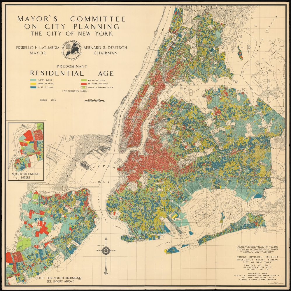

Title
Mayor's Committee on City Planning The City of New York: Predominant Residential Age.
1935 (dated) 37 x 37 in (93.98 x 93.98 cm) 1 : 48000
1935 (dated) 37 x 37 in (93.98 x 93.98 cm) 1 : 48000
Description
FOR THE ORIGINAL ANTIQUE MAP, WITH HISTORICAL ANALYSIS, CLICK HERE.
Digital Map Information
Geographicus maintains an archive of high-resolution rare map scans. We scan our maps at 300 DPI or higher, with newer images being 600 DPI, (either TIFF or JPEG, depending on when the scan was done) which is most cases in suitable for enlargement and printing.
Delivery
Once you purchase our digital scan service, you will receive a download link via email - usually within seconds. Digital orders are delivered as ZIP files, an industry standard file compression protocol that any computer should be able to unpack. Some of our files are very large, and can take some time to download. Most files are saved into your computer's 'Downloads' folder. All delivery is electronic. No physical product is shipped.
Credit and Scope of Use
You can use your digial image any way you want! Our digital images are unrestricted by copyright and can be used, modified, and published freely. The textual description that accompanies the original antique map is not included in the sale of digital images and remains protected by copyright. That said, we put significant care and effort into scanning and editing these maps, and we’d appreciate a credit when possible. Should you wish to credit us, please use the following credit line:
Courtesy of Geographicus Rare Antique Maps (http://www.geographicus.com).
How Large Can I Print?
In general, at 300 DPI, you should at least be able to double the size of the actual image, more so with our 600 DPI images. So, if the original was 10 x 12 inches, you can print at 20 x 24 inches, without quality loss. If your display requirements can accommodate some loss in image quality, you can make it even larger. That being said, no quality of scan will allow you to blow up at 10 x 12 inch map to wall size without significant quality loss. For more information, it is best consult a printer or reprographics specialist.
Refunds
If the high resolution image you ordered is unavailable, we will fully refund your purchase. Otherwise, digital images scans are a service, not a tangible product, and cannot be returned or refunded once the download link is used.
Cartographer S
Bernard S. Deutsch (September 25, 1884 - November 21, 1935) was an American lawyer, politician and Jewish leader. He was born in Baltimore in 1884, but attended CCNY and New York Law School. He began practicing law in 1905, rising to president of the Bronx County Bar Association, member of the Admissions Committee of the New York Bar Association, and member of the New York State Municipal Law Commission. He entered politics in 1932 when the City Bar Association declined to approve either the Democratic or Republican nominees for Supreme Court Justice. Mr. Deutsch gained 300,000 votes as an independent - this led to his nomination as Aldermanic President on the Fusion ticket in 1933. The City Fusion Party was the coalition by which Fiorello La Guardia had won the mayorship, and so Deutch's election by the party would bring him into close association with La Guardia. At the time of his death, he was President of the New York City Board of Aldermen, and was Chairman of the Board of Estimate and Apportionment, and had been president of The American Jewish Congress for seven years, during which he established that organization as an aggressive defender of Jewish rights in the face of widespread antisemitism in the wake of Hitler's rise to power in Germany. Via his Chairmanship of the Board of Estimate and Apportionment, he was put in charge of aspects of municipal policy, budget, and land-use, resulting in the production of an extensive array of maps between 1933 and 1935. More by this mapmaker...
Herman H. Smith (March 2, 1876 - March 3, 1957) was an American engineer. Nothing is known of his early education. He graduated from MIT in 1899, however, and began his career as a construction engineer with the Long Island Railroad. In 1903 he became a surveyor for the Brooklyn Bureau of Highways, later appointed Chief Engineer of Highways. He became Acting Chief Engineer of the New York City Board of Estimate and Apportionment in 1921, and became Chief Engineer in 1928, a post he retained until his retirement in 1934. As Chief Engineer, he was responsible for preparing city maps used to determine zoning and street layout. He also produced master maps for assigning housing projects, parkways, highways, bridges and tunnels. The mapping of Staten Island was a personal focus: he was also a vocal proponent for the development of the Brooklyn-Battery Tunnel (funding issues would prevent work on the tunnel from beginning until 1940.) Learn More...
The Polygraphic Company of America, Inc. (fl. 1924 - 1976) was a commercial printer, established in New York City in 1924. They were noted as pioneers in the use of cut film in the printing process. Eventually, the firm sold the film part of the business to focus on offset lithography. In 1936 the company relocated to Bennington, VT. In 1968 the name was changed to Garrison Printing Division, Inc. The company declared bankruptcy in 1971 and in May 1972 became Economy Graphics, finally closing in 1976. Learn More...
References
OCLC 76832976.