This item has been sold, but you can get on the Waitlist to be notified if another example becomes available, or purchase a digital scan.
1853 Wyld Map of New Zealand
NewZealand-wyld-1853$1,300.00


Title
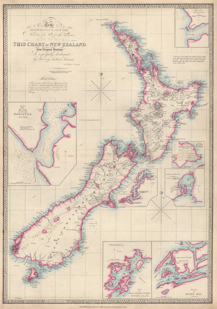
To the Right Honourable the Secretary of State for the Colonies etc. etc. etc. This Chart of New Zealand from Original Surveys is Respectfully Dedicated by His very obedient Servant James Wyld.
1853 (dated) 31 x 21.5 in (78.74 x 54.61 cm) 1 : 2100000
1853 (dated) 31 x 21.5 in (78.74 x 54.61 cm) 1 : 2100000
Description
This is an 1853 James Wyld map of New Zealand - the present example being a rare state of one of the most important 19th-century maps of New Zealand. It does not appear in OCLC and is not cataloged in Tooley's The Mapping of Australia and Antarctica.
A Closer Look
The map depicts the North and South Islands and labels cities, towns, villages, and other settlements. A handful of mountain peaks are named, as are the largest lakes. Short captions are sporadically included on the North Island, some of which highlight mud volcanoes and hot springs. Seven inset maps surround the central map and illustrate the entrance to Port Manoukao, Victoria, Port Nicholson, the Oyerri or Pelorus River, Dusky Bay, Southern Port or Stewart's Island, and include a plan of the Bar and part of the Hokianga River. Just to the right of the inset titled 'Plan of the Bar and Part of the Hokianga River' is a notice that reads 'New Zealand Land Company's Territory, coloured' with a box to indicate the color used to shade in the Land Company's holdings. However, that box is blank, as it is on almost every example of Wyld's map of New Zealand.The New Zealand Land Company
The New Zealand Land Company began as the New Zealand Company, founded in 1825. The Company garnered little attention and no government support and failed. This failure came to the attention of Edward Gibbon Wakefield, an aspiring politician who was serving a three-year jail sentence for the abduction and forced marriage of 15-year-old heiress Ellen Turner, an event known as the Shringley Abduction. Wakefield was released from prison in 1830 and immediately became active in the National Colonial Society, forming the New Zealand Association, hoping it would succeed where the New Zealand Company failed. He chaired its first meeting on May 22, 1837, but the association faced instant opposition from the government and the missionary societies. By September 1837, discussions had already occurred to merge the New Zealand Association with the New Zealand Company. The organizations failed twice to meet the requirements for a Royal Charter, but in 1839, the merged organizations formed the New Zealand Land Company. In 1840, the Company received a royal charter, and its success peaked in 1841. The Company founded Wellington, Dunedin, Wanganui, and Nelson. Financial problems began piling up in 1843, and the Company never recovered. It returned its royal charter in 1850, and all business was concluded by 1858.Publication History and Census
This map was engraved and published by James Wyld in 1853. We have found no cataloged examples of the present edition in OCLC or in other digitized collections. Published between 1834 and 1870, Wyld's map of New Zealand started as the McDonnell-Wyld map of New Zealand. The map's original compiler was Lieutenant Thomas McDonnell. McDonnell worked for the East India Company after retiring from the Navy in 1815 and eventually settled in New Zealand in 1831. McDonnell traveled to England in 1834 and convinced James Wyld to publish a map of New Zealand he had compiled. It is unclear if he did so in New Zealand or after arriving in England. At least 27 editions were subsequently published between 1834 and 1870, with some possibly appearing after that date. Wyld erased McDonnell's name beginning with the 1840 'third edition'. Wyld reengraved the printing plate regularly, making both small and large changes.Cartographer
Wyld (1823 - 1893) was a British publishing firm active throughout the 19th century. It was operated by James Wyld I (1790 - 1836) and his son James Wyld II (November 20, 1812 - 1887) were the principles of an English mapmaking dynasty active in London during much of the 19th century. The elder Wyld was a map publisher under William Faden (1749 - 1836) and did considerable work on the Ordinance Survey. On Faden's retirement in 1823, Wyld took over Faden's workshop, acquiring many of his plates. Wyld's work can often be distinguished from his son's maps through his imprint, which he signed as 'Successor to Faden'. Following in his father's footsteps, the younger Wyld joined the Royal Geographical Society in 1830 at the tender age of 18. When his father died in 1836, James Wyld II was prepared to fully take over and expand his father's considerable cartographic enterprise. Like his father and Faden, Wyld II held the title of official Geographer to the Crown, in this case, Queen Victoria. In 1852, he moved operations from William Faden's old office at Charing Cross East (1837 - 1852) to a new, larger space at 475 Strand. Wyld II also chose to remove Faden's name from all of his updated map plates. Wyld II continued to update and republish both his father's work and the work of William Faden well into the late 1880s. One of Wyld's most eccentric and notable achievements is his 1851 construction of a globe 19 meters (60 feet) in diameter in the heart of Leicester Square, London. In the 1840s, Wyld also embarked upon a political career, being elected to parliament in 1847 and again in 1857. He died in 1887 following a prolific and distinguished career. After Wyld II's death, the family business was briefly taken over by James John Cooper Wyld (1844 - 1907), his son, who ran it from 1887 to 1893 before selling the business to Edward Stanford. All three Wylds are notable for producing, in addition to their atlas maps, short-run maps expounding upon important historical events - illustrating history as it was happening - among them are maps related to the California Gold Rush, the New South Wales Gold Rush, the Scramble for Africa, the Oregon Question, and more. More by this mapmaker...
Condition
Very good. Closed margin tear professionally repaired on verso. Verso repairs to centerfold separations.