1749 Vaugondy Map of Western Africa
NigritieHauteGuinee-vaugondy-1749$200.00

Title
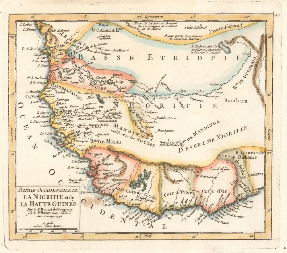
Partie Occidentale de la Nigritie et de la Haute Guinée par le Sr. Robert de Vaugondy fils de Mr. Robert Géog. du Roi.
1749 (dated) 6.5 x 7.75 in (16.51 x 19.685 cm) 1 : 13000000
1749 (dated) 6.5 x 7.75 in (16.51 x 19.685 cm) 1 : 13000000
Description
This is a 1749 Didier Robert de Vaugondy map of western Africa. This map combines the names of African kingdoms (or at least French transliterations of them) with those used by Europeans for parts of the region. Between the 15th and 19th centuries, this region of Africa was the locus of the Atlantic Slave Trade, where millions of Africans were kidnapped and sold into slavery in Brazil, the Caribbean, Mexico, and the modern-day United States.
A Closer Look
Numerous kingdoms and other political entities are identified here, including Dahomey (Royaume de Dahome), the Gold Coast (Cote d'Or) and the Royaume de Mandinga. Villages are labeled throughout the region, and rivers are illustrated. For a modern audience, the most striking notation is Cote des Esclaves, Slave Coast. For nearly 400 years, this region, along with Portuguese Angola, witnessed the capture of over 12 million individuals who were then enslaved and sold to colonial governments on the other side of the Atlantic. The vast majority of these enslaved peoples ended up in Brazil and on islands in the Caribbean.Publication History and Census
This map was created and published by Gilles and Didier Robert de Vaugondy in 1749 in their Atlas Portatif, Universel, et Militaire. Three examples of the separate map are cataloged in OCLC: Muhlenberg College, the Staatsbibliothek zu Berlin, and the Bayerische Staatsbibliothek.Cartographer
Robert de Vaugondy (fl. c. 1716 - 1786) was French may publishing from run by brothers Gilles (1688 - 1766) and Didier (c. 1723 - 1786) Robert de Vaugondy. They were map publishers, engravers, and cartographers active in Paris during the mid-18th century. The father and son team were the inheritors to the important Nicolas Sanson (1600 - 1667) cartographic firm whose stock supplied much of their initial material. Graduating from Sanson's maps, Gilles, and more particularly Didier, began to produce their own substantial corpus. The Vaugondys were well-respected for the detail and accuracy of their maps, for which they capitalized on the resources of 18th-century Paris to compile the most accurate and fantasy-free maps possible. The Vaugondys compiled each map based on their own geographic knowledge, scholarly research, journals of contemporary explorers and missionaries, and direct astronomical observation. Moreover, unlike many cartographers of this period, they took pains to reference their sources. Nevertheless, even in 18th-century Paris, geographical knowledge was limited - especially regarding those unexplored portions of the world, including the poles, the Pacific Northwest of America, and the interiors of Africa, Australia, and South America. In these areas, the Vaugondys, like their rivals De L'Isle and Buache, must be considered speculative or positivist geographers. Speculative geography was a genre of mapmaking that evolved in Europe, particularly Paris, in the middle to late 18th century. Cartographers in this genre would fill in unknown lands with theories based on their knowledge of cartography, personal geographical theories, and often dubious primary source material gathered by explorers. This approach, which attempted to use the known to validate the unknown, naturally engendered rivalries. Vaugondy's feuds with other cartographers, most specifically Phillipe Buache, resulted in numerous conflicting papers presented before the Academie des Sciences, of which both were members. The era of speculative cartography effectively ended with the late 18th-century explorations of Captain Cook, Jean Francois de Galaup de La Perouse, and George Vancouver. After Didier died, his maps were acquired by Jean-Baptiste Fortin, who in 1787 sold them to Charles-François Delamarche (1740 - 1817). While Delamarche prospered from the Vaugondy maps, he defrauded Vaugondy's window Marie Louise Rosalie Dangy of her rightful inheritance and may even have killed her. More by this mapmaker...
Source
Robert de Vaugondy, G., Atlas Portatif, Universel, et Militaire, (Paris: Vaugondy, Durand, Pissot) 1749.
Condition
Very good. Original platemark visible.
References
Pedley, M. S., Bel et Utile, p. 206, 435. OCLC 159769992.