This item has been sold, but you can get on the Waitlist to be notified if another example becomes available, or purchase a digital scan.
1874 Antonio Vallardi Bird's Eye View of the Nile River from the Delta to Khartoum
NiloMedSudan-vallardi-1874$475.00

Title
Il Nilo dal Mediterraneo al Sudan.
1874 (undated) 27.25 x 18.5 in (69.215 x 46.99 cm)
1874 (undated) 27.25 x 18.5 in (69.215 x 46.99 cm)
Description
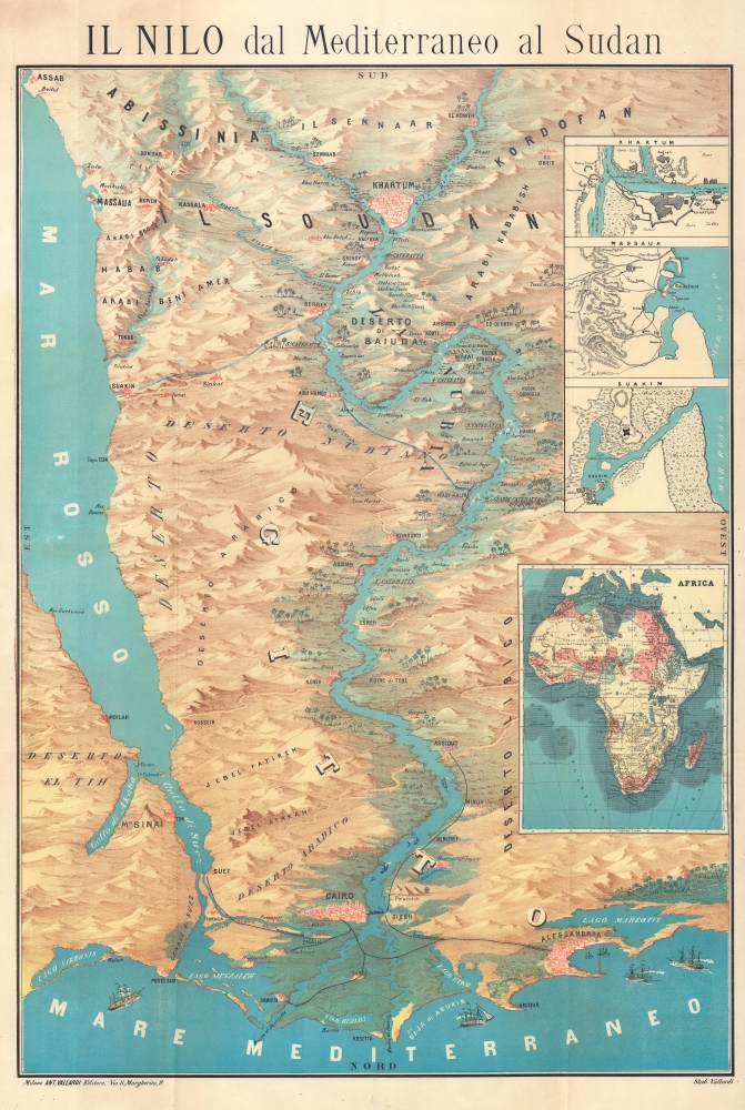
This is a c. 1874 Antonio Vallardi chromolithograph bird's-eye view map of the Nile River of the Nile Delta to Khartoum. The view combines brilliant color with stunning detail to combine Egyptian history with modern progress, such as the railroad network and the Suez Canal.
A Closer Look
Oriented toward the south, the map depicts from Abyssinia and Sudan to the Mediterranean and from the Sinai Peninsula (including Mt. Sinai) to the desert west of the Nile. The Nile Delta and the Mediterranean occupy the foreground, with Alexandria and its lighthouse on the right and Cairo near the center. The Suez Canal, Port Said, and Suez appear on the left. Giza, the Pyramids, and the Great Sphinx appear to the right of Cairo. The region's railroad network is illustrated and connects Cairo with Alexandria, Suez, and Damietta. The railroad network extends south along the Nile to Asyut (Assiout), and steamers are illustrated heading upriver from Cairo. As one travels further up the Nile, towns, and villages are illustrated and labeled on both banks of the Nile, along with monuments and ruins. River hazards, such as cataracts and islands, are marked. Near the top, Khartoum appears at the confluence of the Blue Nile and the White Nile. Four insets are included along the right border. The first three detail Khartoum, Massawa, and Suakin. The fourth depicts the African continent and highlights the colonial possessions of the European powers.Dating This Piece
While the piece is undated, the extent of the railroad network provides a point of reference. The railroad extends south from Cairo as far as Asyut (here as Assiout) in 1874. Two years later, in 1876, Egypt sank into a deep financial crisis, which ended railroad construction. The desire to expand the railroad network would not return in full force until the 1890s.Chromolithography
Chromolithography, sometimes called oleography, is a color lithographic technique developed in the mid-19th century. The process involved using multiple lithographic stones, one for each color, to yield a rich composite effect. Oftentimes, the process would start with a black basecoat upon which subsequent colors were layered. Some chromolithographs used 30 or more separate lithographic stones to achieve the desired product. Chromolithograph color could also be effectively blended for even more dramatic results. The process became extremely popular in the late 19th and early 20th centuries when it emerged as the dominant method of color printing. The vivid color chromolithography produced made it exceptionally effective for advertising and propaganda imagery.Publication History and Census
This map was created and published by Antonio Vallardi Editore in Milan c. 1874. We note a single example cataloged in OCLC, which is part of the collection at the Library of Congress. We note only one other instance when this map has appeared on the private market in recent years.Cartographer
Antonio Vallardi (1813 - 1876) was an Italian publisher and founder of the Antonio Vallardi publishing house. Born into a Milanese publishing family, his grandfather Cesare Vallardi (1736 - 1799) began publishing books in Contrada Santa Margherita in the 1750s. Vallardi's father, Pietro (1770 - 1819), and uncle Giuseppe (1784 - 1861) continued their father's publishing business but renamed the company Fratelli Vallardi and became prominent publishers of books and art prints. Pietro's sons, Franceso and Antonio, both founded their own publishing houses. Antonio Vallardi opened his publishing house in 1843, three years after his brother. Antonio's publishing house became known for academic and linguistic works, alongside the many maps and guides it published for the Touring Club. Antonio's descendants operated the publishing house until 1970, when they sold the firm to Garzanti. More by this mapmaker...
Condition
Good. Light wear along original fold lines. Small areas of loss at some fold intersections. Verso repairs to fold separations. Slight scuffing where previously attached to binder. Accompanied by original binder.
References
OCLC 1315577196.