1858 Milne / Becker Map of Ningbo, China
Ningbo-milne-1858$500.00

Title
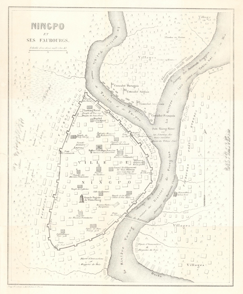
Ningpo et ses Faubourgs.
1858 (undated) 11 x 9 in (27.94 x 22.86 cm) 1 : 22500
1858 (undated) 11 x 9 in (27.94 x 22.86 cm) 1 : 22500
Description
An important c. 1858 map of Ningbo, China by William C. Milne, published in the French translation of his book Life in China, one of the earliest Western maps of the city. Though a long-established port that Europeans had visited as early as 1520, Ningbo had undergone significant changes since the First Opium War (1839 - 1842), after which it became a Treaty Port.
A Closer Look
Oriented towards the north, this map covers the walled city of Ningbo and its environs ('faubourgs') in the late 1840s and early 1850s, when Milne was in residence. Situated along the confluence of the Yong, Yuyao, and Fenghua Rivers, Ningbo's long history as a port and point of foreign interaction is reflected in the cityscape, which includes Chinese Buddhist, Daoist, Confucian, and folk religion temples, a mosque, a Buddhist nunnery, a Protestant missionary girls boarding school, and both Catholic and Protestant churches. Old European trading posts (factories) within the city walls are also noted, dating to the 16th century, when Portuguese actively traded along the coast of Zhejiang. Important civic structures are also labeled, such as a drum tower near the center of the walled city, the city gates, and the imperial examination hall. Around the walled city, suburbs, villages, graveyards, lumber yards, and other features are recorded. The most noticeable of these are the foreign consulates and factories to the north of the walled city (today's Jiangbei District), which appeared in the aftermath of the First Opium War.Seaside City, Cosmopolitan Crossroads
Since the Tang Dynasty (618 - 907 CE), Ningbo has been an important international port, connecting China with ports in Southeast Asia and beyond. In addition to a significant population of traders from the Islamic World, there was even a Jewish community in Ningbo in the early Ming Dynasty, if not much earlier. During the First Opium War, British troops captured the walled city and fought off a Qing counter-attack. Ningbo was selected as one of the five treaty ports opened to foreign trade by the Treaty of Nanjing, which ended the Opium War. The opening of Ningbo to international trade attracted merchants and missionaries from various countries, especially Anglo-American Protestants. Economically, Ningbo became a center for exporting tea, silk, and porcelain, and importing opium and other foreign goods.Publication History and Census
This map was originally engraved by L. M. Becker for the first English edition of Milne's Life in China, published in 1857. Little is known of Becker, but he must have been an associate of Milne in China, possibly another missionary. The present map is a 'fresh' engraving (evidenced, for example, by the lines in the Yong River, which are horizontal in the English-language edition and vertical here), printed by Imprimerie Bineteau for the first French edition of Milne's book (La vie réelle en Chine), published by Hachette in 1858. The map is individually cataloged among the holdings of Leiden University and the Bibliothèque nationale de France in the OCLC, while the entire book is more widely distributed in institutional collections.CartographerS
William Charles Milne (美魏茶; April 22, 1815 - May 25, 1863) was a British Protestant missionary, translator, and interpreter in China. His father, William Milne (1785 - 1822), was one of the first Protestant missionaries to travel to China, and only the second of the London Missionary Society. When Milne the elder died (his wife having preceded him in death), his children were sent back to England for education. William Charles Milne followed in his father's footsteps, joining the London Missionary Society and arriving in Macao in late 1839, in the opening phase of the Opium War. In the following years, Milne traveled throughout China, settling in Shanghai and later in Ningbo, where he served on the Bible Translation Committee. After returning to England for health reasons in 1852, he came back to China in 1856 to work as an interpreter for the British Legation, eventually working as a tutor to British interpreters in Beijing, where he died in 1863. Aside from his translations and other works, Milne's 1857 book Life in China was a popular work in Europe among those curious about China, reflecting his deep knowledge and experience of the country's language and culture. More by this mapmaker...
Francis Paul Becker (fl. 1837 - 1861) was a British artist and engraver who founded F.P. Becker and Company. He also patented 'omnigraphy', a process by which individual letters were punched and not engraved into the plate. Learn More...
Source
Milne, W. C., La Vie Réelle en Chine, (Paris: Hachette) 1858.
Condition
Very good. Minor closed tear form left margin, extending to just within border.
References
OCLC 1204210934, 494970782.