1929 Geographical Publishing Pictorial Resource Map of North America
NorthAmerica-geographical-1929$450.00

Title
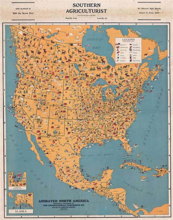
Animated North America.
1929 (dated) 34.5 x 27 in (87.63 x 68.58 cm) 1 : 8230000
1929 (dated) 34.5 x 27 in (87.63 x 68.58 cm) 1 : 8230000
Description
This is a 1929 Geographical Publishing Company pictorial resource map of North America. The map depicts the continent from the Pacific Ocean to the Atlantic Ocean and from the Yukon and Northwest Territories in Canada to Panama and northern Colombia. Myriad symbols populate the map, illustrating the variety of resources, both natural and manufactured, that were available throughout North America. Cities and towns throughout Canada, the United States, Mexico, Central America, Cuba, and Hispaniola are labeled, each of which is associated with certain resources. A legend situated in the upper right corner shows the principal symbols used throughout, although several symbols not included in the legend are employed throughout the map. These symbols are labeled in at least one place, and more often than not several of the same symbol are labeled somewhere. Agriculture, textiles, train stops, foundries, and printing are some of the 'principal symbols' used, while ship building, fertilizer, butter, and other symbols indicate other resources. Each state is labeled, along with each province and each country in Central America. Two inset maps, in the lower left corner, illustrate Chicago and its environs (Geographical Publishing was based in Chicago) and Alaska.
This map was designed and published in 1929 by The Geographical Publishing Company. This particular example was printed by the Southern Agriculturist.
This map was designed and published in 1929 by The Geographical Publishing Company. This particular example was printed by the Southern Agriculturist.
Condition
Good. Even overall toning. Photographs and text on verso.