This copy is copyright protected.
Copyright © 2025 Geographicus Rare Antique Maps
Digital Image: 1930 Margaret Spilhaus Pictorial Map of North America
NorthAmerica-spilhaus-1930_d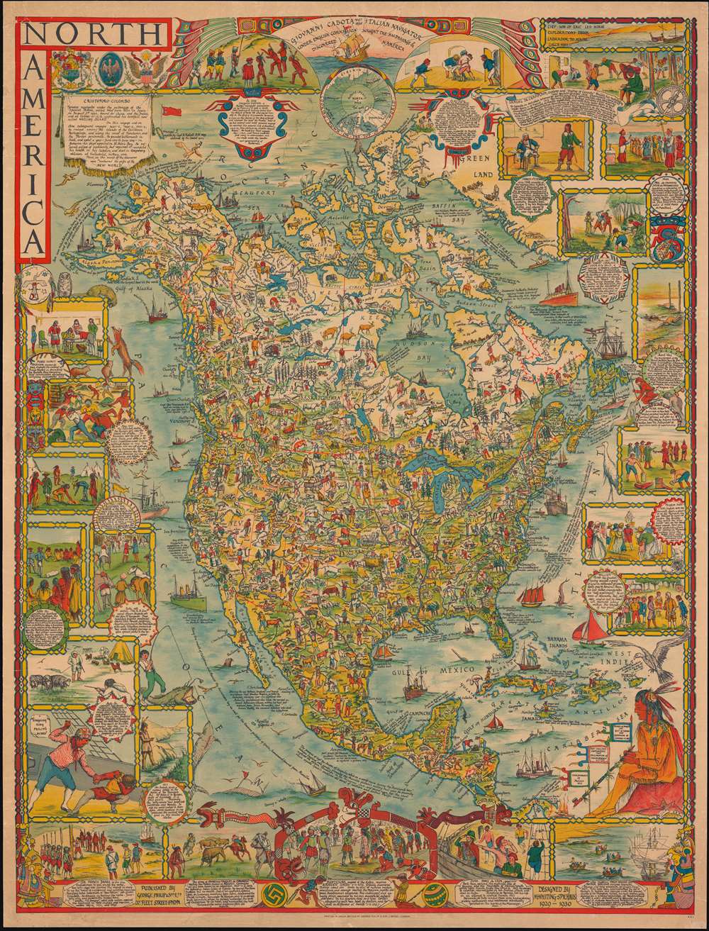


FOR THE ORIGINAL ANTIQUE MAP, WITH HISTORICAL ANALYSIS, CLICK HERE.
Digital Map Information
Geographicus maintains an archive of high-resolution rare map scans. We scan our maps at 300 DPI or higher, with newer images being 600 DPI, (either TIFF or JPEG, depending on when the scan was done) which is most cases in suitable for enlargement and printing.
Delivery
Once you purchase our digital scan service, you will receive a download link via email - usually within seconds. Digital orders are delivered as ZIP files, an industry standard file compression protocol that any computer should be able to unpack. Some of our files are very large, and can take some time to download. Most files are saved into your computer's 'Downloads' folder. All delivery is electronic. No physical product is shipped.
Credit and Scope of Use
You can use your digial image any way you want! Our digital images are unrestricted by copyright and can be used, modified, and published freely. The textual description that accompanies the original antique map is not included in the sale of digital images and remains protected by copyright. That said, we put significant care and effort into scanning and editing these maps, and we’d appreciate a credit when possible. Should you wish to credit us, please use the following credit line:
Courtesy of Geographicus Rare Antique Maps (http://www.geographicus.com).
How Large Can I Print?
In general, at 300 DPI, you should at least be able to double the size of the actual image, more so with our 600 DPI images. So, if the original was 10 x 12 inches, you can print at 20 x 24 inches, without quality loss. If your display requirements can accommodate some loss in image quality, you can make it even larger. That being said, no quality of scan will allow you to blow up at 10 x 12 inch map to wall size without significant quality loss. For more information, it is best consult a printer or reprographics specialist.
Refunds
If the high resolution image you ordered is unavailable, we will fully refund your purchase. Otherwise, digital images scans are a service, not a tangible product, and cannot be returned or refunded once the download link is used.
Margaret Whiting Spilhaus (September 27, 1889 - July 7, 1981), né Phyllis Margaret Whiting, was a British South Africa author, illustrator, geographer, and historian active during the interwar period in the first half of the 20th century. Margaret was born South London. Her father died tragically in 1895, putting her family in difficult circumstances and forcing her into the care of various relatives around London - a story described in her semi-autobiographical work, Doorstep Baby. When her mother remarried in 1902, her family moved to Cape Town South Africa - Margaret herself following in 1904. She married South African - German merchant Ludolph Spilhaus (1876 - 1972) in 1809, taking his name. In cartographic circles, Spilhaus is known for a series of 5 large-format pictorial maps published between 1927 and 1943. These are Africa (1921 - 1925), Australia (c. 1927), North America (1931), South America (1938), and Pan Africa (1943). Her maps were designed for educational purposes, to delight and engage children, as well as advocate her political idealism. She also wrote books on Geography and the significance of maps, historical accounts, and children's books. Spilhaus died in South Africa in July of 1981. More by this mapmaker...
George Philip (1800 - 1882) was a map publisher and cartographer active in the mid to late-19th century. Philip was born into a Calvinst family in Huntly, Aberdeenshire, Scotland. Around 1819 he apprenticed himself to William Grapel, a Liverpool printer and bookseller. Fifteen years later, in 1834, Philip founded his own Liverpool book and map firm. Philip's earliest cartographic ventures were mostly educational material issued in tandem with John Bartholomew Sr., August Petermann, and William Hughes. In 1848, Philip admitted his son, George Philip Jr. (1823 - 1902) into the firm, renaming it George Philip and Son Ltd. George Philip Jr. ran the firm until his death in 1902, by which time it had developed into a major publishing concern. His successors established the London Geographical Institute, a factory where they embraced modern printing techniques to produce thousands of economical and high quality maps. In April 1988, George Philip & Son was acquired by Octopus Publishing, a branch of Reed International. Nonetheless, today the firm trades and publishes to this day as George Philip and Son. Learn More...
Copyright © 2025 Geographicus Rare Antique Maps | Geographicus Rare Antique Maps
This copy is copyright protected.
Copyright © 2025 Geographicus Rare Antique Maps