This item has been sold, but you can get on the Waitlist to be notified if another example becomes available, or purchase a digital scan.
1755 Mitchell / Tirion Map of North America
NorthAmerica-tirion-1755$475.00

Title
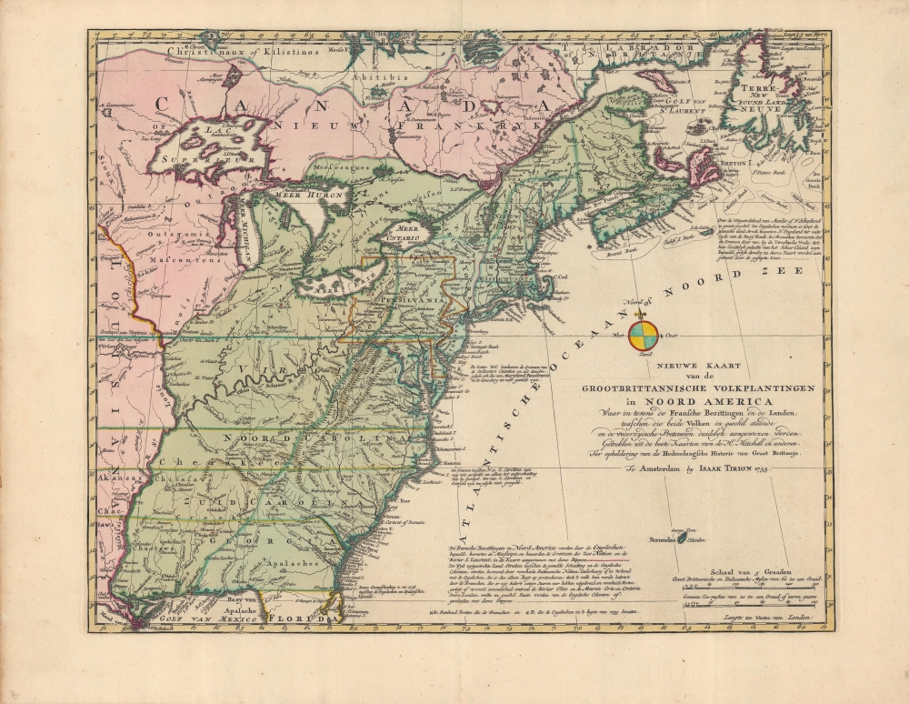
Nieuwe kaart van de Grootbrittannische volkplantingen in Noord America : waar in tevens de Fransche bezittingen en de Landen, tusschen die beide volken in geschil staande en de wederzydsche pretensien duidelyk aangewezen worden.
1755 (dated) 14.25 x 17.75 in (36.195 x 45.085 cm) 1 : 7000000
1755 (dated) 14.25 x 17.75 in (36.195 x 45.085 cm) 1 : 7000000
Description
A very fine example of Issak Tirion's 1755 map of North America, a Dutch translation on a reduced scale of the famous 'Mitchell Map' published the same year. Tirion's adaptation is significant for highlighting the speed with which cartographic knowledge spread across Europe in the context of competition between global empires.
By the time Mitchell published his map in 1755, the British in French were locked in yet another global conflict with a significant North American component, the Seven Years' War (French and Indian War, 1754 - 1763). In the years after 1755 and even after his death, Mitchell's map continued to be updated with extensive notes on sources employed. It played a central role in the negotiations resulting in the Treaty of Paris in 1783, ending the American Revolutionary War, and in subsequent border disputes between the U.S. and Great Britain.
A Closer Look
Coverage extends from New France to Florida, and from the Mississippi River in the west to the Atlantic coast in the east. Tirion follows Mitchell's presentation, though without the detailed notes on sources of information or the inset of Hudson Bay to allow for the reduced scale. However, notes on the settlement of boundaries are compiled, rearranged, and even expanded upon those from Mitchell's map. Native American groups are recorded in some detail, particularly those with which the British were most familiar, such as the Six Nations of the Iroquois. British and French forts are marked with red and labelled, highlighting the proximity of their respective forces.A Brief History of the Mitchell Map
Mitchell, who was born in Virginia but spent most of his adulthood in England, first produced a map of North America in 1750, either on his own initiative or at the request of George Montagu-Dunk, 2nd Earl of Halifax, a colonial administrator in North America (historians debate the origins of the map's production). In either case, the two men shared a concern about the vulnerability of Britain's North American colonies to French invasion. The War of the Austrian Succession (also known as King George's War, 1744 - 1748) had just ended with little in the way or territorial changes, but it took a heavy toll on the British colonists in New England, leaving them ill prepared for another fight.By the time Mitchell published his map in 1755, the British in French were locked in yet another global conflict with a significant North American component, the Seven Years' War (French and Indian War, 1754 - 1763). In the years after 1755 and even after his death, Mitchell's map continued to be updated with extensive notes on sources employed. It played a central role in the negotiations resulting in the Treaty of Paris in 1783, ending the American Revolutionary War, and in subsequent border disputes between the U.S. and Great Britain.
Publication History and Census
This map was published by Issak Tirion in Amsterdam in 1755, based on John Mitchell's map 'A Map of the British and French Dominions in North America…' published in London the same year. It appeared in the book Hedendaagsche historie, of tegenwoordige staat van Groot Brittanie, a partial translation of Thomas Salmon's work on English history. It was later re-issued in Tirion's 1769 Nieuwe en Beknopte Hand-Atlas. Covens and Mortier published Mitchell's map (in English) in Amsterdam in 1755, considered to be the first Dutch edition of the map, but Tirion's was perhaps the first edition of the Mitchell map in Dutch. Due to the complexities of authorship and the date of the map's publication, it is listed in the OCLC ten times, with about thirty institutions worldwide noting it among their catalogs, while the entire Hedendaagsche historie… is somewhat more widely distributed.CartographerS
Isaak Tirion (1705 - 1765) was a Dutch publisher in Amsterdam. Born in Utrecht, Tirion quickly rose to prominence by publishing pamphlets, historical works, and most importantly, maps and atlases. He produced several atlases and Dutch town plans. His maps are mainly based on those of Guillaume de l'Isle. Tirion eventually relocated his printing house to the prestigious Kalverstraat. In his long career, he produced eight atlases in multiple editions, some of which were published posthumously until about 1784. More by this mapmaker...
John Mitchell (April 13, 1711 – February 29, 1768) was and British-American mapmaker of great significance. He is known for one and only one map, the 'Mitchell Map', considered the most important map in 18th century American history. Mitchell was born in Lancaster County, Virginia, the son of a prosperous planter and merchant. Like many of his social peers, he was educated in Europe, at Scotland at Edinburgh University, where he studied medicine. Mitchell practiced medicine in Virginia for a short time prior to the French and Indian War. He was elected to the original American Philosophical Society in 1744. In 1745 Mitchell argued that a series of epidemics occurring in Virginia were due to unsanitary troop ships from Britain - at the time a revolutionary idea. He relocated to London in 1746 - presumably for the agreeable climate. Mitchell never practiced medicine in London, but was known to be an avid botanist, and was considered an exotic plant expert in London society circles. He was elected as a fellow of the Royal Society in November 1748, his candidature citation describing him as
A Gentleman of great merit and Learning, who Some time Since communicated to the Royal Society a very curious dissertation concerning the Colour of the skin in Negroes, and who from his long residence in Virginea, and from his great application to the Study of Natural history, especially Botany, is very well acquainted with the vegetable productions of North America, being desirous of being admitted a fellow of the Royal Society, is recommended by us from our personal knowledge of him as highly deserving the Honour he desires, as we believe he will be (if chosen) a usefull and valuable member of our Body.As an educated American adopted into British high society, Mitchell became the de facto expert on all matters North American. In 1749, during a time of ever-increasing political tensions between British and French interests in America, Lord Halifax contracted Mitchell to produce a large and detailed map of British and French dominions in America. While embracing the most advanced geographical data, Mitchell also advocated pro-British interpretation of political boundaries. The resulting map was thus geographically unimpeachable and reframed the cartographic perspective from French to British terms. The map proved significant and was used in most subsequent treaties. Michell issued 3 editions in his lifetime. He died in London in 1768. Learn More...
Condition
Very good. Slight creasing along the fold line.
References
OCLC 5401778.