Digital Image: 1798 Dilly Map of the Northern United States and the Northwest Ordinance
NorthernPartUS-dilly-1798_d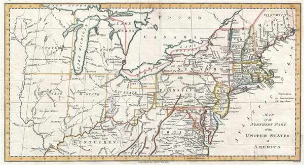

Title
Map of the Northern Part of the United States of America.
1798 (dated) 8.25 x 15.5 in (20.955 x 39.37 cm) 1 : 6000000
1798 (dated) 8.25 x 15.5 in (20.955 x 39.37 cm) 1 : 6000000
Description
FOR THE ORIGINAL ANTIQUE MAP, WITH HISTORICAL ANALYSIS, CLICK HERE.
Digital Map Information
Geographicus maintains an archive of high-resolution rare map scans. We scan our maps at 300 DPI or higher, with newer images being 600 DPI, (either TIFF or JPEG, depending on when the scan was done) which is most cases in suitable for enlargement and printing.
Delivery
Once you purchase our digital scan service, you will receive a download link via email - usually within seconds. Digital orders are delivered as ZIP files, an industry standard file compression protocol that any computer should be able to unpack. Some of our files are very large, and can take some time to download. Most files are saved into your computer's 'Downloads' folder. All delivery is electronic. No physical product is shipped.
Credit and Scope of Use
You can use your digial image any way you want! Our digital images are unrestricted by copyright and can be used, modified, and published freely. The textual description that accompanies the original antique map is not included in the sale of digital images and remains protected by copyright. That said, we put significant care and effort into scanning and editing these maps, and we’d appreciate a credit when possible. Should you wish to credit us, please use the following credit line:
Courtesy of Geographicus Rare Antique Maps (http://www.geographicus.com).
How Large Can I Print?
In general, at 300 DPI, you should at least be able to double the size of the actual image, more so with our 600 DPI images. So, if the original was 10 x 12 inches, you can print at 20 x 24 inches, without quality loss. If your display requirements can accommodate some loss in image quality, you can make it even larger. That being said, no quality of scan will allow you to blow up at 10 x 12 inch map to wall size without significant quality loss. For more information, it is best consult a printer or reprographics specialist.
Refunds
If the high resolution image you ordered is unavailable, we will fully refund your purchase. Otherwise, digital images scans are a service, not a tangible product, and cannot be returned or refunded once the download link is used.
Cartographer S
Charles Dilly (1739 - 1807) was an English bookseller born in Bedfordshire to yeoman parents. After a short trip to America, he returned to London, where his brother Edward partnered with him to create a publishing firm. They published James Boswell’s Life of Johnson and Tour of the Hebrides and Lord Chesterfield’s Miscellaneous Works along with other works. He and his brother led an active social life and hosted many memorable dinners at The Poultry, hosting many distinguished guests. His brother Edward died in 1779, but Charles continued the business on his own, and maintained his active social life. Charles retired after a career which lasted over 40 years, and passed away while on his way to visit Richard Cumberland. More by this mapmaker...
Abraham Bradley, Jr. (1767 - 1838) was an American lawyer, judge, and cartographer who served as assistant postmaster general for thirty years. Bradley was responsible for moving the federal post office from Philadelphia to Washington, D.C. and even hosted the national post office in his home for a period. He was employed under five different U.S. postmasters general and drew detailed and innovative maps of postal routes. Bradley, after having established his private law practice in 1788, briefly served as a county judge. There he became acquainted with Timothy Pickering, who was appointed by President Washington as postmaster general in 1791. Bradley served as his clerk, and began compiling information for a complete postal service map. Bradley's extensive knowledge of the department and the routes made him indispensable when Pickering was succeeded in 1795. Bradley is regarded as an influential figure in the early history of the Post Office. His postal routes and schedules were rigidly enforced for thirty years and gave the department a 'rapid and reliable engine for delivering information across vast distances'. Learn More...