
This item below is out of stock, but another example (left) is available. To view the available item, click "Details."
Details
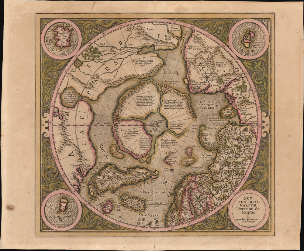
1595 First Edition Mercator Map of the Arctic (1st Map of the North Pole)
1595 (undated) $30,000.00
1606 Mercator / Hondius Map of the Arctic (First Map of the North Pole)
NorthPole-mercator-1606-3$2,250.00

Title
Septentrionalium Terrarum descriptio.
1606 (undated) 15 x 16 in (38.1 x 40.64 cm) 1 : 34214400
1606 (undated) 15 x 16 in (38.1 x 40.64 cm) 1 : 34214400
Description
This is the 1606 second Hondius state of Gerard Mercator's map of the North Pole or Arctic, one of the great cartographer's most interesting and important maps. This map marks a significant step forward in the cartographic understanding of the high Arctic, representing the transition between medieval and modern cosmographical perspectives.
A Closer Look
Mercator's Arctic projection has its roots in his magnificent 1569 wall map of the world, in which he introduces the revolutionary Mercator Projection. As regards the Arctic, the problem with the Mercator Projection is that, to accurately depict the Polar Regions, a map would have to be infinitely tall. Mercator compensated by including an inset polar projection, very similar to the map shown here, in the lower-left corner of this wall map. That inset was the world's first specific map of the North Pole. Mercator later reissued this map in an expanded format for his 1595 atlas. After several important expeditions to the Arctic over the subsequent 10 years, Mercator's successor, Jodocus Hondius, reissued the map with numerous seminal changes.Taking It From The Top
Beginning with the North Pole itself, Mercator envisions a large black rock, the Rupes Nigra, surrounded by a great whirlpool into which four powerful rivers flow. These rivers divide a massive continent-sized landmass into four distinct islands or countries. When the English polymath John Dee wrote to Mercator asking about his sources for this map, Mercator returned the following letter, which survives in his own hand:In the midst of the four countries is a Whirl-pool, into which there empty these four indrawing Seas which divide the North. And the water rushes round and descends into the Earth just as if one were pouring it through a filter funnel. It is four degrees wide on every side of the Pole, that is to say eight degrees altogether. Except that right under the Pole, there lies a bare Rock in the midst of the Sea. Its circumference is almost 33 French miles, and it is all of magnetic Stone (…) This is word for word everything that I copied out of this author years ago.The author that Mercator refers to is generally believed to be Jacobus Cnoyen van Herzogenbusch, who is himself referencing an enigmatic lost work, the Inventio Fortunata (Fortunate Discoveries). Little is known of this work, save that it was composed in the 14th century and was a well-known resource for cartographers of the 15th and 16th centuries. The author of this work is a figure of considerable mystery, and arguments have been made that he is Nicholas of Lynn, Thomas Kingsbury, or Hugh of Ireland. The work tells of a Minorite monk from Oxford who traveled extensively in northern lands, including Iceland, Greenland, Norway, and possibly even Labrador. The Inventio also itself references a far older and similarly lost work, the Gestae Arthuri, which adds a new chapter to the legend of King Arthur, citing that his warriors conquered Iceland, Greenland, the Faeroes, and parts of Norway.
Zeno and Frisland
The difficulty Mercator confronted in presenting a map of such remote regions is not just that the sources available to him were few, but that they could not be confirmed - resulting in the perpetuation of geographical information that was arguably concocted deceptively. Hence, his inclusion of the phantom island of Frisland, between Greenland and Iceland. Mercator's delineation of this region is drawn from the 1558 map of Nicolo Zeno the Younger, informed by the purported explorations of his 14th-century forbears Nicolo and Antonio Zeno. The brothers Zeno allegedly explored the coasts of Greenland and Labrador and, as such, were held forth as Venetian discoverers of America. Modern historical consensus has been that Nicolo the Younger's map was a hoax, with a minority of dissenters considering it a confused re-telling of a legitimate voyage. Some archival evidence places the Zeno brothers in Venice at the time they were supposedly at sea; it is possible that they never voyaged at all. Nevertheless, in the 16th century, Zeno's map was accepted as legitimate. It represented the first attempt at mapping the remote north Atlantic. So its many phantom islands - notably Frisland - would be included on the maps of Mercator and other cartographers well into the 17th century. Mercator thought Frisland important enough that he assigned one of three detail maps to it: the other two roundels portray the Shetland Islands and the Faroe Islands, respectively.Indigenous Peoples
One of the large polar islands, located north of Norway, Mercator claims is the home to a band of female Pygmies. This, too, references the old English voyages described in the Inventio Fortunata. The author seems clear that no vessel could survive the Polar Rivers or the great maelstrom, so any hope to describe the region accurately can be only speculative. Nevertheless, here we have a reference that suggests an actual voyage to the region. The female Pygmies may well be a reference to Lapland Eskimos, who are indeed small in stature. The fact that the group was predominantly female is consistent with Eskimo hunting patterns in which the men will often leave in groups for extended hunts.Hondius' Updates: Old Meets New
Mercator's original map from his 1569 wall map, as well as the first edition of his atlas map of the Arctic, published in 1595, shows four complete islands with a solid coastline. This edition marks a significant leap forward in Arctic cartography. Mercator completed his 1595 map just before he died in 1594. Two years later, the Dutchman Barentz, searching for the Northwest Passage, discovered Spitsbergen and rounded the northern tip of Nova Zembla. This incredible achievement redefined the cartographic perspective of the region, for the newly discovered islands were well into the latitudes where Mercator mapped his four Arctic countries. In 1606, Mercator's heir, Jodocus Hondius, had to redraw Mercator's 1595 map to account for the Dutch discoveries in Spitsbergen and Nova Zembla (Novaya Zemlya). Attempting to reconcile recent discoveries with a century of cosmographical convention, Hondius erased part of the 'Pygmei' island and instead added Nieulant, Willoughbbe's Land, and MacFin - alternate names for the islands of Spitsbergen.North America
Mercator's mapping of North America on the left-hand side is also of interest. There are no significant changes in Hondius' 1606 treatment of the northern parts of America over Mercator's 1595 map; however, there are significant differences between the 1595 map and the 1569 inset map, which left the region blank. Mercator must have come across new information regarding the northern part of the Americas in the intervening years. One such example is the 'Lago de Conibaz,' a large lake with a central island that has an outlet into a great Arctic Bay to the northeast of the Straight of Anian. Conibas appeared on several earlier maps, including its first appearance on the 1575 Thevet Map. Thevet is known to have met with Cartier and may have derived the lake from these conversations. Some suggest that the term refers to 'Cornibotz,' an alternate name for Wampum shells. In any case, some scholars have associated this lake with Great Salt Lake, Lake Ontario, the Great Lakes in general, and some of the other large Canadian lakes. Whatever it may be - and there is a great deal of mystery here - it does suggest that European cartographers had some sense of the great inland lakes of North America long before their official discovery.Revelations in Central Asia
Opposite the American side of the Strait of Anian, is the Asian land of Gog, which appears bound in a tight ring of mountains. Gog and Magog, Biblical nations from the Book of Revelations, were associated by many Europeans with the Tartars. It was believed that Alexander the Great walled off the Kingdom of Gog and Magog behind a mountain range. Many early maps, following up on this legend as well as references from the journals of Marco Polo, place either Gog or Magog in the northeastern extreme of Asia behind an impenetrable mountain range.Publication History and Census
This updated state of Mercator's map was introduced in the 1606 Latin edition of the Mercator and Hondius Atlas. This example conforms typographically to the 1619 French-text edition of the atlas. We see this edition of the separate map cataloged in two separate institutional examples at the University of Bern and the Bayerische Staatsbibliothek. The full atlas is somewhat better represented.CartographerS
Gerard Mercator (March 5, 1512 - December 2, 1594) is a seminal figure in the history of cartography. Mercator was born near Antwerp as Gerard de Cremere in Rupelmonde. He studied Latin, mathematics, and religion in Rupelmonde before his Uncle, Gisbert, a priest, arranged for him to be sent to Hertogenbosch to study under the Brothers of the Common Life. There he was taught by the celebrated Dutch humanist Georgius Macropedius (Joris van Lanckvelt; April 1487 - July 1558). It was there that he changed him name, adapting the Latin term for 'Merchant', that is 'Mercator'. He went on to study at the University of Louvain. After some time, he left Louvain to travel extensively, but returned in 1534 to study mathematics under Gemma Frisius (1508 - 1555). He produced his first world map in 1538 - notable as being the first to represent North America stretching from the Arctic to the southern polar regions. This impressive work earned him the patronage of the Emperor Charles V, for whom along with Van der Heyden and Gemma Frisius, he constructed a terrestrial globe. He then produced an important 1541 globe - the first to offer rhumb lines. Despite growing fame and imperial patronage, Mercator was accused of heresy and in 1552. His accusations were partially due to his Protestant faith, and partly due to his travels, which aroused suspicion. After being released from prison with the support of the University of Louvain, he resumed his cartographic work. It was during this period that he became a close fried to English polymath John Dee (1527 - 1609), who arrived in Louvain in 1548, and with whom Mercator maintained a lifelong correspondence. In 1552, Mercator set himself up as a cartographer in Duisburg and began work on his revised edition of Ptolemy's Geographia. He also taught mathematics in Duisburg from 1559 to 1562. In 1564, he became the Court Cosmographer to Duke Wilhelm of Cleve. During this period, he began to perfect the novel projection for which he is best remembered. The 'Mercator Projection' was first used in 1569 for a massive world map on 18 sheets. On May 5, 1590 Mercator had a stroke which left him paralyzed on his left side. He slowly recovered but suffered frustration at his inability to continue making maps. By 1592, he recovered enough that he was able to work again but by that time he was losing his vision. He had a second stroke near the end of 1593, after which he briefly lost speech. He recovered some power of speech before a third stroke marked his end. Following Mercator's death his descendants, particularly his youngest son Rumold (1541 - December 31, 1599) completed many of his maps and in 1595, published his Atlas. Nonetheless, lacking their father's drive and genius, the firm but languished under heavy competition from Abraham Ortelius. It was not until Mercator's plates were purchased and republished (Mercator / Hondius) by Henricus Hondius II (1597 - 1651) and Jan Jansson (1588 - 1664) that his position as the preeminent cartographer of the age was re-established. More by this mapmaker...
Jodocus Hondius (October, 14 1563 - February 12, 1612) was an important Dutch cartographer active in the late 16th and early 17th centuries. His common name, Jodocus Hondius is actually a Latinized version of his Dutch name, Joost de Hondt. He is also sometimes referred to as Jodocus Hondius the Elder to distinguish him from his sons. Hondius was a Flemish artist, engraver, and cartographer. He is best known for his early maps of the New World and Europe, for re-establishing the reputation of the work of Gerard Mercator, and for his portraits of Francis Drake. Hondius was born and raised in Ghent. In his early years he established himself as an engraver, instrument maker and globe maker. In 1584 he moved to London to escape religious difficulties in Flanders. During his stay in England, Hondius was instrumental in publicizing the work of Francis Drake, who had made a circumnavigation of the world in the late 1570s. In particular, in 1589 Hondius produced a now famous map of the cove of New Albion, where Drake briefly established a settlement on the west coast of North America. Hondius' map was based on journal and eyewitness accounts of the trip and has long fueled speculation about the precise location of Drake's landing, which has not yet been firmly established by historians. Hondius is also thought to be the artist of several well-known portraits of Drake that are now in the National Portrait Gallery in London. In 1593, Hondius returned to Amsterdam, where he remained until the end of his life. In 1604, he purchased the plates of Gerard Mercator's Atlas from Mercator's grandson. Mercator's work had languished in comparison to the rival atlas, Theatrum Orbis Terrarum by Ortelius. Hondius republished Mercator's work with 36 additional maps, including several which he himself produced. Despite the addition of his own contributions, Hondius recognizing the prestige of Mercator's name, gave Mercator full credit as the author of the work, listing himself as the publisher. Hondius' new edition of Mercator revived the great cartographer's reputation and was a great success, selling out after a year. Hondius later published a second edition, as well as a pocket version called the Atlas Minor. The maps have since become known as the "Mercator/Hondius series". Between 1605 and 1610 Hondius was employed by John Speed to engrave the plates for Speed's The Theatre of the Empire of Great Britaine. Following Hondius' death in 1612, his publishing work in Amsterdam was continued by his widow and two sons, Jodocus II and Henricus. Later his family formed a partnership with Jan Jansson, whose name appears on the Atlasas co-publisher after 1633. Eventually, starting with the first 1606 edition in Latin, about 50 editions of the Atlas were released in the main European languages. In the Islamic world, the atlas was partially translated by the Turkish scholar Katip Çelebi. The series is sometimes called the 'Mercator/Hondius/Jansson' series because of Jansson's later contributions. Hondius' is also credited with a number of important cartographic innovations including the introduction of decorative map borders and contributions to the evolution of 17th century Dutch wall maps. The work of Hondius was essential to the establishment Amsterdam as the center of cartography in Europe in the 17th century. Learn More...
Source
Mercator, G. and Hondius, J., Atlas, 1619.
Condition
Very good. Areas of oxidation reinforced with no loss. Surface mend to top just entering image. Even toning. Original color.
References
OCLC 956283416. Taylor, E.G.R. (1956). 'A Letter Dated 1577 from Mercator to John Dee', Imago Mundi 13: 56–68. Van der Krogt, P. C. J., Koeman's Atlantes Neerlandici, 0020:1A. Burden, P., The Mapping of North America: A List of Printed Maps, 1511-1670, 88. Verner, Coolie and Stuart-Stubbs, B., The North Part of America, p. 142-187. National Library of Australia, 1628 MAP RM 150. Ginsberg, William B., Printed Maps of Scandinavia and the Arctic, 1482-1601, 33.3. Kershaw, K., Early Printed Maps of Canada, 23C. Costa, B. F., 'Arctic Exploration', Journal of the American Geographical Society of New York, Vol 12, p. 159-192. Pool, J., 'Spitsbergen: Early Exploration and Mapping', IMCOS Journal, vol 121, 35-42.