This copy is copyright protected.
Copyright © 2025 Geographicus Rare Antique Maps
Digital Image: 1766 Muller Map of the Bering Strait (Alaska, Siberia, Pacific Northwest)
NouvelleCarteDecouvertes-muller-1766_d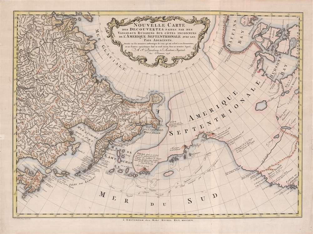

FOR THE ORIGINAL ANTIQUE MAP, WITH HISTORICAL ANALYSIS, CLICK HERE.
Digital Map Information
Geographicus maintains an archive of high-resolution rare map scans. We scan our maps at 300 DPI or higher, with newer images being 600 DPI, (either TIFF or JPEG, depending on when the scan was done) which is most cases in suitable for enlargement and printing.
Delivery
Once you purchase our digital scan service, you will receive a download link via email - usually within seconds. Digital orders are delivered as ZIP files, an industry standard file compression protocol that any computer should be able to unpack. Some of our files are very large, and can take some time to download. Most files are saved into your computer's 'Downloads' folder. All delivery is electronic. No physical product is shipped.
Credit and Scope of Use
You can use your digial image any way you want! Our digital images are unrestricted by copyright and can be used, modified, and published freely. The textual description that accompanies the original antique map is not included in the sale of digital images and remains protected by copyright. That said, we put significant care and effort into scanning and editing these maps, and we’d appreciate a credit when possible. Should you wish to credit us, please use the following credit line:
Courtesy of Geographicus Rare Antique Maps (http://www.geographicus.com).
How Large Can I Print?
In general, at 300 DPI, you should at least be able to double the size of the actual image, more so with our 600 DPI images. So, if the original was 10 x 12 inches, you can print at 20 x 24 inches, without quality loss. If your display requirements can accommodate some loss in image quality, you can make it even larger. That being said, no quality of scan will allow you to blow up at 10 x 12 inch map to wall size without significant quality loss. For more information, it is best consult a printer or reprographics specialist.
Refunds
If the high resolution image you ordered is unavailable, we will fully refund your purchase. Otherwise, digital images scans are a service, not a tangible product, and cannot be returned or refunded once the download link is used.
Gerhard Friedrich Müller (Фёдор Ива́нович Ми́ллер; October 29, 1705 - October 22, 1783), also known as Fyodor Ivanovich Miller, was a Russian-German historian, ethnologist and cartographer. He was born in Herford and educated at Leipzig. In 1725, he was among the European scholars invited to St. Petersburg to co-found the Imperial Academy of Sciences. Müller took part in the Academy's Great Northern Expedition (Second Kamchatka Expedition; 1733 - 1743), he and eighteen scientists and artists traveled the area to perform ethnological and botanical studies, as well as collecting data for the creation of maps. Müller's descriptions and categorizations of clothing, religions and rituals of the Siberian ethnic groups earned him the title 'father of ethnography.' He produced an essential map of the arctic and sub-arctic regions of the Pacific in 1754, motivated to counter the geographic frauds perpetrated by Joseph Nicholas De l’Isle (1688 - 1768) and Phillippe Buache (1700 - 1773). He knew both Vitus Bering (1733 - 1743) and Aleksei Chirikov (1703 - 1748), and was as close to his subject matter as any cartographer of his age. More by this mapmaker...
Marc-Michel Rey (May 5, 1720 - June 8, 1780) was a French Huguenot publisher, author, and bookseller active in the Amsterdam in the mid-18th century. Rey was born Geneva, Switzerland. Although he had little formal education, he was apprenticed to the Geneva bookseller Marc-Michel Bosquet from 1733 to 1744. Reaching he maturity, he relocated to Amsterdam, then the capital of the European book trade, where he purchased citizenship and commenced to publishing. Two years later, having quickly establishing himself in the rich Dutch market, he married Elisabeth Bernard, the daughter of a prominent Amsterdam bookseller, Jean Frederic Bernard (1680 - 1744), also of French Huguenot descent. Rey issued few maps, but in the exerted a strong influence on the publishing world. In the words of Utrecht Scholar Wijnand.W. Mijnhardt, 'The Bernard-Rey dynasty was a vital force in the French book trade on Dutch soil for almost 70 years, from 1711 until 1780.' (The Amsterdam booksellers Jean Frederic Bernard (1680-1744) and Marc Michel Rey (1720-1780)). Learn More...
Leonard Schenk Janszoon (February 26, 1696 - June 11, 1767) was a Dutch engraver, the son of Petrus Schenk (Pieter Schenck) the Elder (1660 - 1711). Leonard was bornin Amsterdam and was tough engraving in his father's workshops. Most of Leonard's work focused on geography and architecture, but he also has a significant corpus of portraiture. Leonard engraved several maps and also carried on his father’s relationship with engraving plates for the Amsterdam edition of the Histoire de l'Académie Royale des Sciences. Leonard inherited neither his father's publishing legacy or business, all of which went to his older brothers, but remained a prolific private engraver in the Amsterdam trade through the late 18th century. Learn More...
Copyright © 2025 Geographicus Rare Antique Maps | Geographicus Rare Antique Maps
This copy is copyright protected.
Copyright © 2025 Geographicus Rare Antique Maps