1671 Ogilby View of Mexico City, Mexico
NovaMexico-ogilby-1671$600.00

Title
Nova Mexico.
1671 (undated) 11.25 x 21.25 in (28.575 x 53.975 cm)
1671 (undated) 11.25 x 21.25 in (28.575 x 53.975 cm)
Description
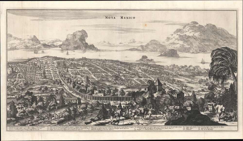
A rare and impressive view of Mexico City from John Ogilby's 1671 America. This is one of the first representations of Mexico City as a Spanish colonial center.
A Closer Look
The view is oriented towards the east, overlooking Mexico City from Chapultepec Hill, with the eponymous forest (Bosque de Chapultepec) in the foreground. It is a significant deviation from earlier maps and views that typically presented Mexico as Tenochtitlan, as it was under the Aztecs or at least very early in the colonial period. However, here the colonial grid laid out by the Spanish is clearly evident. Towards the top-left is the city's cathedral, royal palace, and main square (Zócalo). Churches, convents, and monasteries belonging to various religious orders are numbered, corresponding to the index below the view. A large aqueduct runs from the foreground to the background at the left. The remnant of Lake Texcoco appears in the background - partially drained to control flood and disease. In the foreground are intersecting groups, including perhaps African-descended city residents and animals laden with goods.Publication History and Census
This view was prepared for John Ogilby's 1671 book America being the latest, and most accurate description of the New World…. It is based on the view of Mexico City that appeared in Arnoldus Montanus' De Nieuwe en Onbekende Werlde, engraved by Jacob van Meurs, which was also translated into German by Olfert Dapper as Die Unbekante Neue Welt…. Although the works in which it appeared were published in Dutch (Montanus), English (Ogilby), or German (Dapper), the text at the bottom of the view is in Spanish in all cases, making them indistinguishable. The view, as attributed to Ogilby, is independently cataloged among the holdings of the Newberry Library, the University of Texas at Arlington, the British Library, and the National Library of Scotland, while the Bayerische Staatsbibliothek independently catalogs it attributed to Montanus. Attributed to Dapper, it is cataloged with the Bayerische Staatsbibliothek, the Staatliche Bibliothek Regensburg, the Universität Erlangen-Nürnberg, and the Bibliothèque nationale de France. This view remained the standard view of Mexico City for several decades and was also incorporated into contemporary composite atlases.CartographerS
John Ogilby (November 17, 1600 - 1676) was a Scottish translator and cartographer. John Ogilby's life seems to be one of extremes, teetering between wealth and poverty, success and failure. Ogilby was born near Edinburgh, Scotland, into a once wealthy family laid low by extreme debt. Struggling with poverty at every turn, Ogilby involved himself in various businesses ranging from dancing master, to actor, to tutor. In 1612, at age 12, Ogilby won a lottery run to advance the colonial interests of Virginia. His winning were sufficient to pay of many of his father's debts and apprentice himself to a dancing master. Ogilby proved a natural and graceful dancer and even made extra money tutoring his fellow apprentices. Starcrossed as he was, Olgiby's dancing career ended when a misstep when a misstep at a masked ball injured his leg and left him lame for live. Afterwards he managed to leverage his contacts in the dance world to secure a position as a dance instructor to the daughters of Sir Ralph Hopton. Hopton struck an immediate friendship with Olgiby and trained him in Military Science. Later Ogilby relocated to Ireland where he worked an as actor and later as Master of Revels. The Irish Rebellion of 1641 again dashed Ogilby's fortunes and forced him to flee Dublin by ship. On the way, the ship sunk but the survivors were rescued and eventually made their way to England, which was then under the strict rule of Oliver Cromwell. Ogilby took refuge at Cambridge where he mastered Greek and Latin. Following the Restoration of Charles II, Ogilby invested in his first major literary venture, a translation of Virgil into English. This work earned him the patronage of Charles II, despite the ridicule of prominent poets Dryden and Pope. Under Royal patronage Ogilby published several volumes relating to the Restoration. In short order he has established a successful London publisher based out of the Whitefriars district. This, unfortunately turned out to be a fateful choice of location as in 1666 the Great Fire of London tore through this are destroying Ogilby's publishing stock, home, and business. Once again Ogilby exhibited a remarkable phoenix-like ability to literally rise from the ashes. Shortly after the Great Fire, he began his most important ventures as a publisher of geographical works. In order to recover from the fire, Ogilby and his grandson were took positions as surveyors commissioned to create a large property map of London. The resultant map of London, "London Survey'd", was published in 1677 and earned Ogilby the honorific "Kings Cosmographer and Geographic Printer". His most famous works are his 1675 Road Atlas of England, Britannia which redefined road mapping, and his 1671 Atlas of the Americas. More by this mapmaker...
Arnoldus Montanus (c. 1625 - 1683) was a Dutch scholar, publisher, schoolmaster and author active in Amsterdam during the latter half of the 17th century. Montanus is a Latinized form of van den Berg or van Bergen. He studied theology at Leiden University and was ordained a minister in 1653. In 1667 he became headmaster of the Latin School of Schoonhoven, where he died in 1683. Most of Montanus's work was published in conjunction with engraver Jacob van Meurs and focused on travel narratives to Asia and the Americas. His most famous book, De Nieuwe en Onbekende Weereld, contains what is arguably the first view of New York City, the New Amsterdam. His other works offer up some of the earliest known descriptions of China and Japan. Much of Montanus' work was translated and published in English by John Ogilby. Learn More...
Jacob van Meurs (c. 1620 - 1680) was a Dutch engraver active in Amsterdam during the second half of the 17th century. Van Meurs is best known for his collaboration with Arnoldus Montanus in the publication of numerous engraved maps and views for Montanus' various influential histories and travel narratives. Some of his most important works include a few of the earliest known views of the Americas (including New York City), Japan, and China. Learn More...
Source
Ogilby, J., America, (London) 1671.
Condition
Very good. Light wear along original folds. Closed margin tear professionally repaired on verso.
References
OCLC 70665937, 945632665, 164561024, 495028103.