This copy is copyright protected.
Copyright © 2025 Geographicus Rare Antique Maps
Digital Image: 1600 Matthias Quad Map of North America
NoviOrbisAmerica-quad-1600-2_d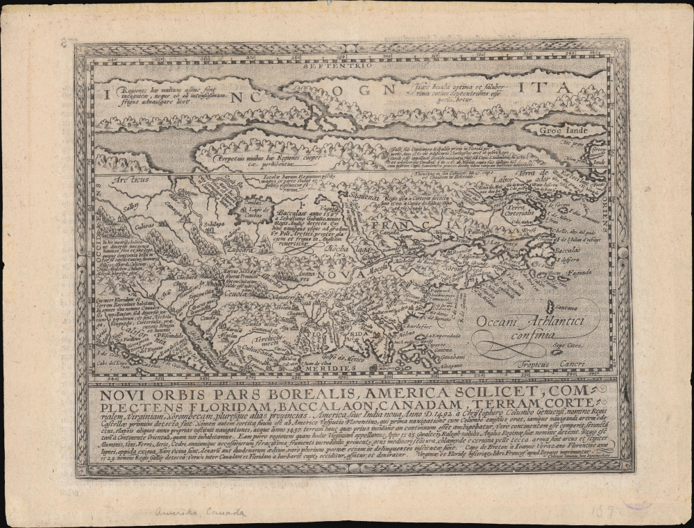

FOR THE ORIGINAL ANTIQUE MAP, WITH HISTORICAL ANALYSIS, CLICK HERE.
Digital Map Information
Geographicus maintains an archive of high-resolution rare map scans. We scan our maps at 300 DPI or higher, with newer images being 600 DPI, (either TIFF or JPEG, depending on when the scan was done) which is most cases in suitable for enlargement and printing.
Delivery
Once you purchase our digital scan service, you will receive a download link via email - usually within seconds. Digital orders are delivered as ZIP files, an industry standard file compression protocol that any computer should be able to unpack. Some of our files are very large, and can take some time to download. Most files are saved into your computer's 'Downloads' folder. All delivery is electronic. No physical product is shipped.
Credit and Scope of Use
You can use your digial image any way you want! Our digital images are unrestricted by copyright and can be used, modified, and published freely. The textual description that accompanies the original antique map is not included in the sale of digital images and remains protected by copyright. That said, we put significant care and effort into scanning and editing these maps, and we’d appreciate a credit when possible. Should you wish to credit us, please use the following credit line:
Courtesy of Geographicus Rare Antique Maps (http://www.geographicus.com).
How Large Can I Print?
In general, at 300 DPI, you should at least be able to double the size of the actual image, more so with our 600 DPI images. So, if the original was 10 x 12 inches, you can print at 20 x 24 inches, without quality loss. If your display requirements can accommodate some loss in image quality, you can make it even larger. That being said, no quality of scan will allow you to blow up at 10 x 12 inch map to wall size without significant quality loss. For more information, it is best consult a printer or reprographics specialist.
Refunds
If the high resolution image you ordered is unavailable, we will fully refund your purchase. Otherwise, digital images scans are a service, not a tangible product, and cannot be returned or refunded once the download link is used.
Matthias Quad (1557 - October 29, 1613) was Dutch engraver active in Cologne during the late 16th and early 17th centuries. Quad was born in the Netherlands and studied engraving under Johannes van Deutecum (fl. 1552 - 1606) of Deventer and Hendrick Goltzius (1558-1616) of Haarlem. Around 1580 he relocated to Heidelberg or Cologne where he primarily engraved geographical texts in conjunction with fellow publisher Johann Bussemacher. In 1608 he published an atlas, Fasciculus Geographicus, with Bussemacher in Cologne. In 1609, another major work, his Teutscher Nation Herligkeit, a historico-cultural regional study of Germany, was published by Wilhelm Lutzenkirchen . More by this mapmaker...
Johann Bussemacher (fl. c. 1580 - 1613) was a German publisher, engraver, art dealer, and bookseller active in Cologne in the late 16th and early 17th centuries. He was trained as a copper engraver in Dusseldorf, where he was born. Around in 1583 he established his own imprint and a publishing concern in Cologne. Bussemacher was for a time the largest and most successful publisher in Cologne. He is commonly associated with producing engraved images of saints and noble personages, but he also issued several maps in conjunction with Matthias Quad. Learn More...
Copyright © 2025 Geographicus Rare Antique Maps | Geographicus Rare Antique Maps
This copy is copyright protected.
Copyright © 2025 Geographicus Rare Antique Maps