This item has been sold, but you can get on the Waitlist to be notified if another example becomes available, or purchase a digital scan.
1939 Annand Pictorial Map of New York City and World's Fair
NYCPictorial-annand-1939-2$225.00

Title
Sinclair Pictorial Map of New York. / New York World's Fair.
1939 (dated) 26.5 x 27.5 in (67.31 x 69.85 cm)
1939 (dated) 26.5 x 27.5 in (67.31 x 69.85 cm)
Description
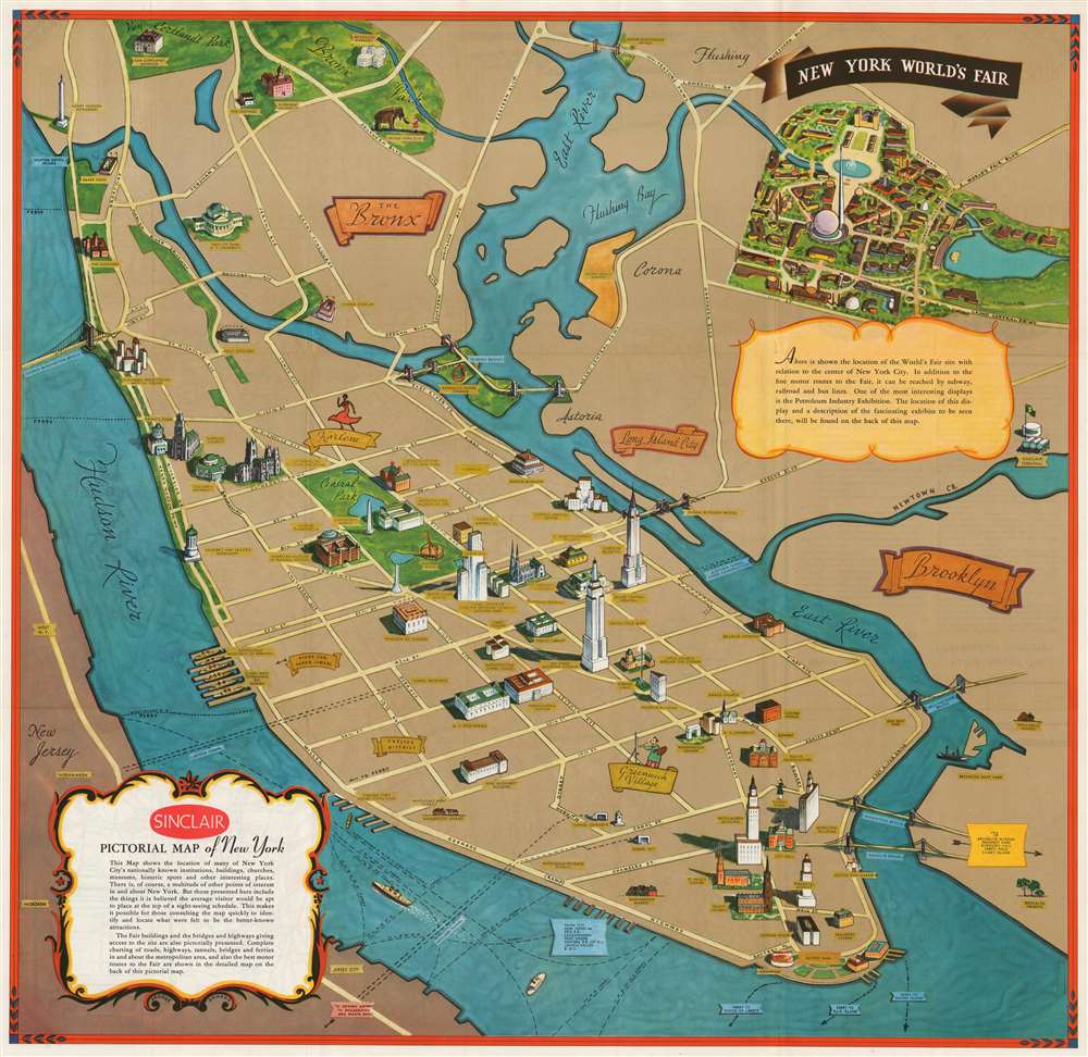
This is a scarce pictorial map of New York City drawn in 1939 by Georg Annand for Sinclair Oil to promote the 1939 New York World's Fair. The map is a simplified perspective view of the island of Manhattan, with Flushing and the Bronx retreating into the distance and Central Park taking center stage. Like most of Annand's work, this map combines pictorial and minimalist tendencies. The typography is clear and legible; by dispensing with all but the most important thoroughfares, Annand is able to pictorially present a selection of the city's landmarks, such as its skyscrapers, museums and cathedrals. Several sports venues are shown: Madison Square Garden, Yankee Stadium, and the lamented Polo Grounds. The Bronx Zoo is depicted with an improbable scene of a little girl in a red dress stroking an elephant's trunk. Two neighborhoods are highlighted: Greenwich Village (indicated with an artist at an easel) and Harlem (indicated with a dancer in a smashing red dress.) Also noted: the Fulton Fish Market.
The Verso
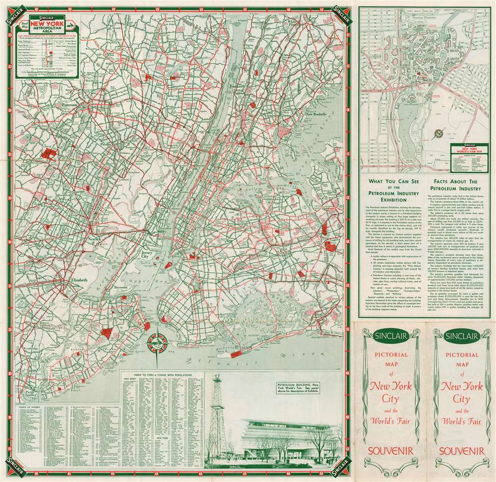
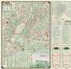
As attractive as it is, the recto map would not be of much utility to a new visitor to the 1939 Worlds' Fair. The maps on the verso solve the problem: a detailed road map of the New York vicinity, and a detail map of the Fair Grounds - along with a description of Sinclair's sponsored exhibition on the Petroleum Industry, presented in a boldly optimistic light characteristic of the period.Publication History and Census
This map was printed in 1939 by Rand McNally and Company and presented as a souvenir at the World's Fair. The map is scarce: we see only six examples catalogued in institutional collections.CartographerS
George Annand (June 9, 1890 - September, 1980) was an American graphic artist and cartographer active in New York during the middle part of the 20th century. Annand was born in Croswell, Michigan, the sun of a Scottish immigrant doctor who immigrated to the United States via Canada. He received his early education at a one-room schoolhouse in Croswell before he and his parents relocated to Detroit. It was in Detroit that Annand was first introduced to the arts, enrolling in Art School. Later, as a young man, Annand move to New York City, where he continued his artistic studies at the Art Students League. In 1920 he married a childhood friend, Elizabeth Sinclair, who had been widowed during World War I. He adopted Elizabeth's two children and she and Annand shortly thereafter became pregnant with a third child. With a family to support and another 'bun in the oven' Annand turned to the booming New York advertising industry, taking work with the National Biscuit Company (NABISCO). He did well at NABISCO painting, as he liked to joke 'Fig Newtons in their native habitat.' He also took freelance work designing illustrated book covers. One of his first such jobs was illustrating a cover for C. E. Montague's Right off the Map. Naturally, given the nature of the work, the cover featured a map incorporating pictorial elements with aspects of baroque era cartography - Annand's first pictorial map. The Wall Street Crash of 1929 hit Annand's interests hard and he lost his job a Nabisco. Refusing WPA work for reasons of personal pride, Annand managed to get by on odd illustration contracts for various companies including publishers like Doubleday, Doran, and Charles Scribner, as well as pictorial map work for the Waldorf Astoria Hotel, General Foods, Sinclair Oil, and more. His cartographic work eventually drew the attention of the Chicago based map publishing giant Rand McNally, who commissioned him to produce two of their popular 'Romance Maps.' During and after World War II business began to pick up again and Annand produced a huge corpus of pictorial maps. His style combined decorative elements from 16th century Dutch decorative cartography, fine calligraphy, and more contemporary pictorial work. He wanted his maps are noteworthy for their clarity and the sense of space they convey. Annand was, according to Stephen Horsby in Picturing America: The Golden Age of Pictorial Maps, 'a cartographer's cartographer.' Annand continued to produce pictorial maps until forced to sop due to cataract surgery in 1970. He died 10 years later in 1980, at 90 years old. More by this mapmaker...
Rand, McNally and Co. (fl. 1856 - present) is an American publisher of maps, atlases and globes. The company was founded in 1856 when William H. Rand, a native of Quincy, Massachusetts, opened a print shop in Chicago. Rand hired the recent Irish immigrant Andrew McNally to assist in the shop giving him a wage of 9 USD per week. The duo landed several important contracts, including the Tribune's (later renamed the Chicago Tribune) printing operation. In 1872, Rand McNally produced its first map, a railroad guide, using a new cost effective printing technique known as wax process engraving. As Chicago developed as a railway hub, the Rand firm, now incorporated as Rand McNally, began producing a wide array of railroad maps and guides. Over time, the firm expanded into atlases, globes, educational material, and general literature. By embracing the wax engraving process, Rand McNally was able to dominate the map and atlas market, pushing more traditional American lithographic publishers like Colton, Johnson, and Mitchell out of business. Eventually Rand McNally opened an annex office in New York City headed by Caleb S. Hammond, whose name is today synonymous with maps and atlases, and who later started his own map company, C. S. Hammond & Co. Both firms remain in business. Learn More...
Condition
Very good. Minor wear along original fold lines.
References
Rumsey 8242.003. OCLC 27440854.