Title
Map of Oakland, Alameda, Berkeley Piedmont and Vicinity.
1920 (dated)
19.75 x 25.75 in (50.165 x 65.405 cm)
1 : 25000
Description
This is a 1920 H. A. Candrian and Bertha Wilhemina Candrian map of the cities of Oakland, Berkeley, Alameda, and surrounding communities in the East Bay of the San Francisco Bay Area. It demonstrates the rapid development of the East Bay at this time, including new residential developments, public transportation, and hydrological infrastructure. It is, moreover, one of the few maps of the era to have been drafted by a woman - H. A. Candrian's wife, Bertha Wilhemina.
A Closer Look
Oriented towards the north-northeast, the map covers from Kensington and El Cerrito in the north to Alameda in the south and as far east as the Oakland neighborhoods of Elmhurst and Sequoyah. Cities, neighborhoods, streets, rail lines, waterways (including reservoirs), and other features are labeled throughout. Many interesting local landmarks are identified, including those listed in the legend at the bottom-left, such as the 'New Chabot Observatory' (opened 1915), the basis for today's Chabot Space and Science Center. At top-right is an advertisement for George L. Suhr's funeral services, a common partner with Candrian.
Next to the advertisement is an inset of the San Francisco Sacramento Railroad, a short-lived line that succeeded the equally short-lived Oakland, Antioch and Eastern Railway. Originally meant to compete with the Southern Pacific and Western Pacific, the San Francisco Sacramento Railroad was bought by the latter in 1922. The map also reflects the curious situation whereby the East Bay developed two robust, competing streetcar networks covering much of the same territory, the Key System (traced in red here by the map's original owner) and the East Bay Electric Lines, owned by the Southern Pacific Railroad. Both systems were intended to link together the growing cities of the East Bay and to get commuters to the Key-owned pier ('mole') in Alameda or the Southern Pacific-owned Oakland mole.
Around the time of this map's publication, Southern Pacific considerably expanded their pier facilities in order to separate freight and passenger traffic (explaining the 'proposed Southern Pacific pier' at bottom-left). In fact, the entire area at bottom-left transformed in the years after World War I (1914 - 1918), aided by a booming economy and money from the city, state, and federal government to improve waterways for commercial traffic. But with money and upgraded facilities came oversight, leading to the creation of the Board of Port Commissioners in 1927, which greatly improved the Port of Oakland's operations.
The surveyed but undeveloped 'Brooklyn Town' and 'Eden Township' at top-right (anachronistic names for areas later incorporated into Oakland and other nearby cities) never were developed for commercial or residential use, instead becoming parkland or being subsumed in the Upper San Leandro Reservoir (filled after the completion of the San Leandro Dam in 1926, and more reliably after the completion of the Mokelumne Aqueduct in 1929). Indeed, the hills are dotted with reservoirs and land belonging to the 'water company,' meaning the East Bay Water Company, the last in a succession of companies founded by East Bay grandees (including Anthony Chabot) to supply the growing region with potable water. These companies tended to fail quickly whenever there was a drought (the local water supply was strained even in good years) and also due to intense competition and price wars. Therefore, soon after this map's publication, all existing and competing interests were gathered by the state into the East Bay Municipal Utility District and supplied with water from the state's interior via aqueducts, such as the aforementioned Mokelumne Aqueduct.
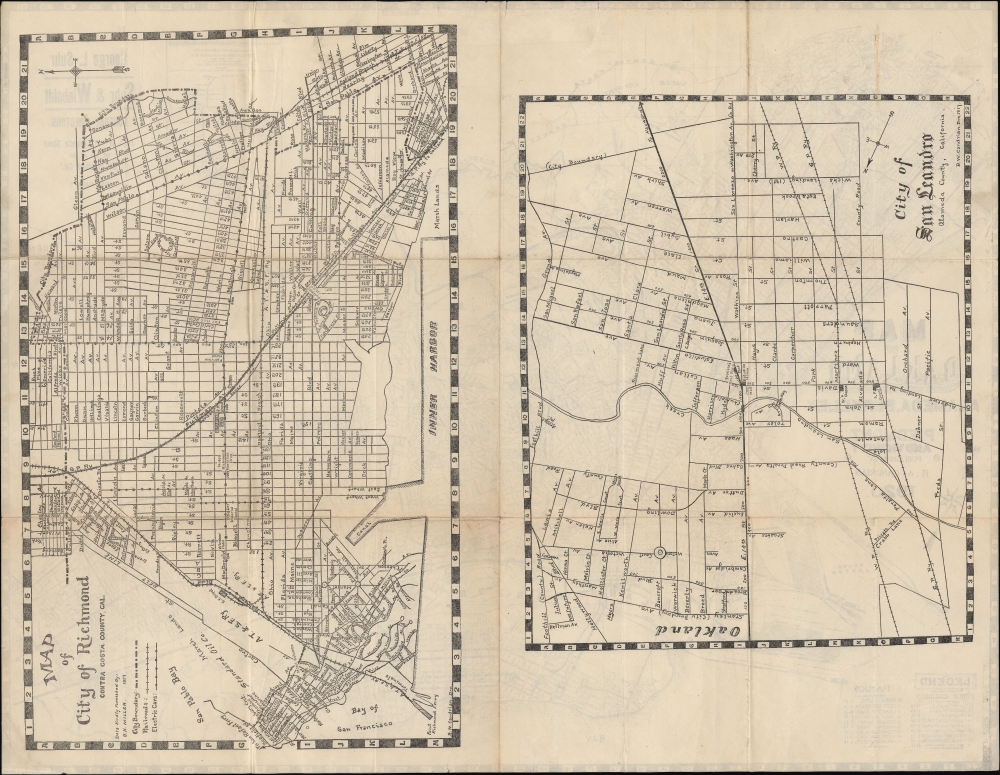
The verso contains city plans of Richmond and San Leandro, to the north and south, respectively, of the area covered on the recto map. Like the area as a whole, these suburbs were growing at a tremendous pace, especially Richmond, where an Atchison, Topeka, and Santa Fe Railway pier and a large Standard Oil facility seen at left here opened at the start of the 20th century, launching the city's development. The map of Richmond notes the location of several hotels and, at center, a brewery for producing El Capitan Beer, a product of Enterprise Brewing based in San Francisco. Publication History and Census
The recto map was prepared by Herman Anton Candrian and is dated 1920. The verso maps, dated 1917, are noted as having been drawn by 'B.W. Candrian,' who was not a son or other male relation but instead Candrian's wife, Bertha Wilhemina Candrian (née Harry). Bertha Wilhemina Candrian appears as the draughtswoman on Candrian maps as early as 1906, with an apparent focus on maps of the East Bay.
We have been unable to locate another example of this map in institutional collections or on the market, while earlier editions of Candrian maps of the East Bay do occasionally appear in institutional holdings or on the market (such as the 1906 edition previously sold by us as SanFrancisco-candrian-1906-2), usually on the verso of San Francisco maps, as Candrian had a tendency to 'mix and match' different maps depending on the year and audience, with his maps almost always being double-sided.
CartographerS
Hermon Anton Candrian (March 28, 1852 - November 28, 1928), commonly publishing as H. A. Candrian, was a Swiss-American map publisher active in San Francisco in the first half of the 20th Century. Candrian was born in Bonaduz, Graubünden, Switzerland. It is unclear when he emigrated to the Untied States, but he working as an insurance agent in Seattle around 1900 and by 1905 had relocated to San Francisco. From at least 1906, his wife, Bertha Wilhemina Candrian (née Harry; 1862 - 1944), drafted many of his maps. Candrian’s works focus heavily and tourist and railway guides to the city of San Francisco and the general Bay Area. More by this mapmaker...
Bertha Wilhemina Candrian (October 2, 1862 - March 14, 1944) was a San Francisco housewife and map draftswoman. Bertha, née Harry, was born in Illinois. Little is known of her early life or education, but she married Hermon Anton Candrian (1852 - 1928) was living with her husband in San Francisco as early as 1906. Hermon Candrain became a prominent map publisher and as early as 1906 began leaning on Bertha to draft his maps. Few maps actually feature her imprint, B. W. Candrian, but it can be assumed she was an active part of the firm until her husband's death in 1928. Learn More...
Condition
Very good. Light wear along original fold lines. Pencil annotations along streetcar lines. Maps on verso.
References
OCLC 773935581 (later editions).