1952 Hubbard Pictorial View of Jack London Square, Oakland, California
OaklandJackLondon-hubbard-1952$300.00

Title
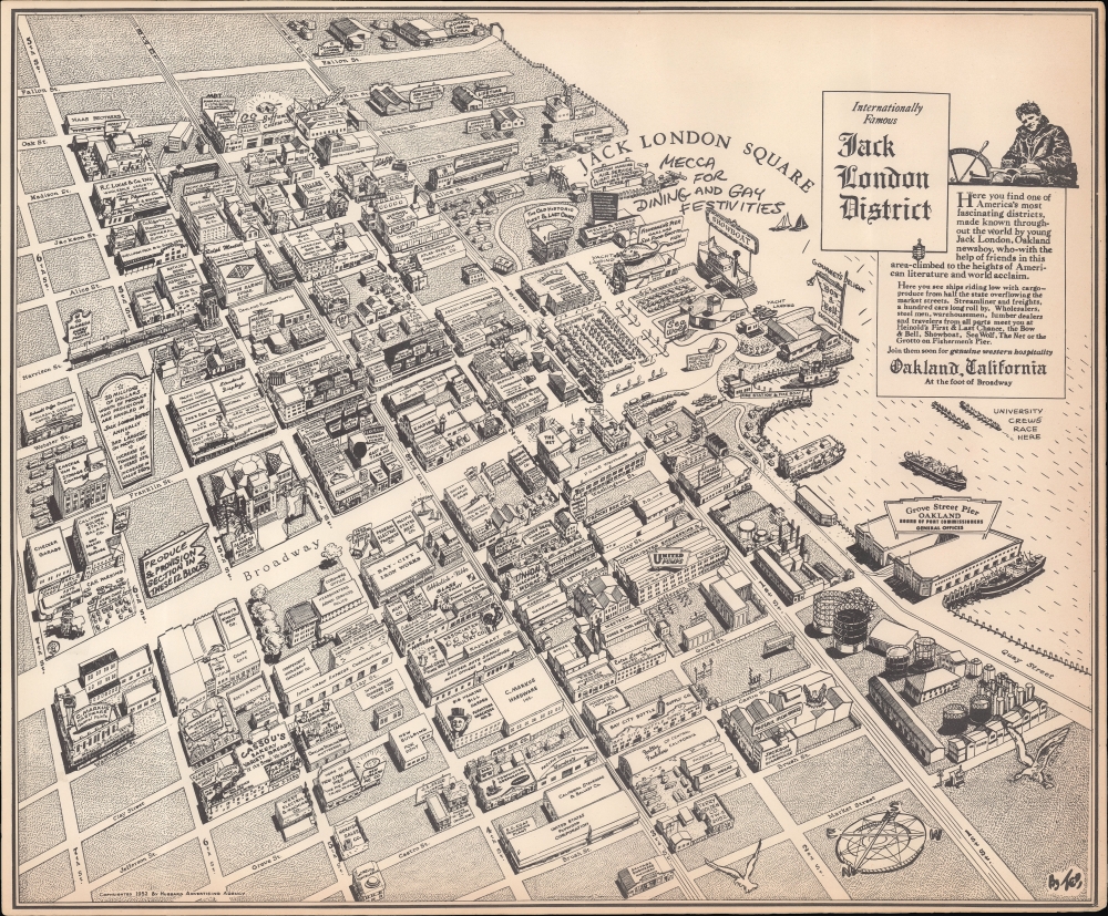
Internationally Famous Jack London District.
1952 (dated) 18.25 x 15.25 in (46.355 x 38.735 cm)
1952 (dated) 18.25 x 15.25 in (46.355 x 38.735 cm)
Description
This is a 1952 Alva 'Ted' Hubbard pictorial view of the Jack London District (Jack London Square), Oakland, California. Created to mark the dedication of the district, the view documents the area's vibrancy and diversity amidst a landscape of warehouses.
A Closer Look
This view is oriented towards the southeast, with the Oakland Inner Harbor at right and streets leading to Downtown Oakland at left. Many businesses are illustrated and labeled, mostly consisting of warehouses, wholesalers, and the like, but also restaurants, hotels, and entertainment venues near on the waterfront, including a seaplane flight school. Although many of the businesses have rather generic names and are long forgotten, others are familiar today (Safeway, Farmers Brothers, Goodwill), while others give a sense of the ethnic diversity of Oakland at the time, including Italian fishmongers, Mexican restaurants, and the Housewives' Market towards bottom-left, known at the time as a center for 'ethnic foods.' Streets are labeled throughout and rail lines, utilized by the Southern Pacific, Western Pacific, and Santa Fe Railroad, traced (a passenger train is seen pulling into the First and Broadway Station near center). The lovely Art Deco Posey Tube to Alameda, an engineering marvel in its time, is indicated.Jack London Square
The Jack London District (now Jack London Square) is named after the famous author (1876 - 1910), who spent part of his youth in the area, working as an oyster pirate, sealer, and various other odd-jobs. Some of the buildings seen here, such as Heinold's First and Last Chance Saloon, were the source of inspiration for scenes and characters in London's novels, including the sadistic sea captain and titular character of his 1904 novel The Sea Wolf (the saloon still operates today with the same furnishings as it had in London's time). Others, especially the Sea Wolf Restaurant (a wonderful Mid-Century Modern structure), are, in turn, direct references to London's work. Located near several rail networks, especially those operated by the Southern Pacific Railroad, the area emerged in the early 20th century as a warehouse district, as can be seen here. By 1950, the Board of Port Commissioners (with offices at the Grove St. Pier seen here) sought to rebrand the area to develop into something akin to Fisherman's Wharf in San Francisco. This project has never fully succeeded but several establishments have managed to survive through the area's ups and downs, and recent years have seen considerable development, including a ferry terminal and an Amtrak station between 1st (now Embarcadero) and 2nd St. and Alice St.Publication History and Census
This view was drawn by Alva 'Ted' Hubbard and copyrighted by his Hubbard Advertising Agency in 1952, coinciding with the dedication of the square the previous year. It is only noted in the OCLC among the holdings of Yale University, while an example is also held by the David Rumsey Historical Map Collection.Cartographer
Alva Traver 'Ted' Hubbard (1899 - 1989) was a businessman, journalist, newspaper and journal editor, and illustrator active in the San Francisco Bay Area. Born in Michigan, Hubbard moved to California (Huntington Park, near Los Angeles) in his youth and attended the University of California at Berkeley. After serving in World War I, he held several prominent positions, including as the Secretary of the San Francisco Chamber of Commerce (his later illustrations were often done in conjunction with local chambers of commerce). He increasingly worked as an editor and illustrator, depicting various sites around the San Francisco Bay Area in a distinctive, realistic bird's eye view style. In the 1960s, Hubbard relocated to the Sacramento Valley, where he went on to edit several newspapers. More by this mapmaker...
Condition
Very good.
References
Rumsey 12321.000. OCLC 1240445083.