This copy is copyright protected.
Copyright © 2025 Geographicus Rare Antique Maps
Digital Image: 1963 Wright and Fischer Pictorial Map of Oklahoma Civil War Sites
OklahomaCivilWarCentennial-wrightfischer-1963_d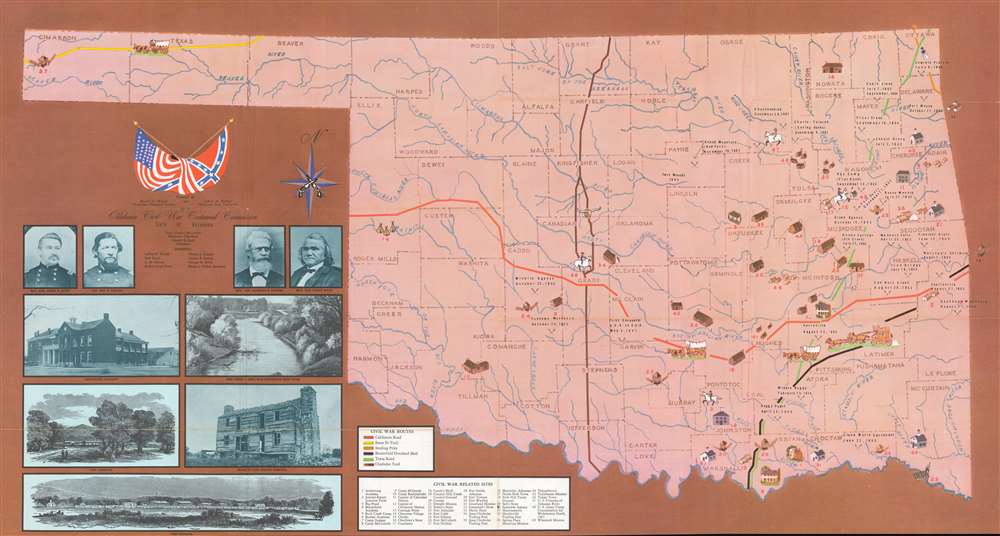

FOR THE ORIGINAL ANTIQUE MAP, WITH HISTORICAL ANALYSIS, CLICK HERE.
Digital Map Information
Geographicus maintains an archive of high-resolution rare map scans. We scan our maps at 300 DPI or higher, with newer images being 600 DPI, (either TIFF or JPEG, depending on when the scan was done) which is most cases in suitable for enlargement and printing.
Delivery
Once you purchase our digital scan service, you will receive a download link via email - usually within seconds. Digital orders are delivered as ZIP files, an industry standard file compression protocol that any computer should be able to unpack. Some of our files are very large, and can take some time to download. Most files are saved into your computer's 'Downloads' folder. All delivery is electronic. No physical product is shipped.
Credit and Scope of Use
You can use your digial image any way you want! Our digital images are unrestricted by copyright and can be used, modified, and published freely. The textual description that accompanies the original antique map is not included in the sale of digital images and remains protected by copyright. That said, we put significant care and effort into scanning and editing these maps, and we’d appreciate a credit when possible. Should you wish to credit us, please use the following credit line:
Courtesy of Geographicus Rare Antique Maps (http://www.geographicus.com).
How Large Can I Print?
In general, at 300 DPI, you should at least be able to double the size of the actual image, more so with our 600 DPI images. So, if the original was 10 x 12 inches, you can print at 20 x 24 inches, without quality loss. If your display requirements can accommodate some loss in image quality, you can make it even larger. That being said, no quality of scan will allow you to blow up at 10 x 12 inch map to wall size without significant quality loss. For more information, it is best consult a printer or reprographics specialist.
Refunds
If the high resolution image you ordered is unavailable, we will fully refund your purchase. Otherwise, digital images scans are a service, not a tangible product, and cannot be returned or refunded once the download link is used.
Muriel Hazel Wright (March 31, 1889 - February 27, 1975) was an American historian, cartographer, editor, and teacher. Born in Lehigh, Choctaw Nation, Indian Territory, her mother, Ida Belle Richards, was a Presbyterian missionary teacher and her father, Dr. Eliphalet Nott Wright, was a Choctaw and a graduate of Union College and Albany Medical College in New York. Wright was proud of her biracial heritage. Throughout her life Wright was active in Choctaw Nation policy making. She served as the secretary of the Choctaw Committee during the 1920s and in 1934 was a member and secretary of the Choctaw Advisory Committee. In the late 1930s and early 1940s Wright served as a Choctaw delegate to the Intertribal Indian Council. Muriel Wright was educated in Norton, Massachusetts at Wheaton Seminary and returned to Lehigh in 1910. In 1912 Wright completed a teacher education course at East Central Normal School but never received a degree. Nonetheless, she held positions as principal and history and English teacher in various schools in southeast Oklahoma. She studied English and History at Barnard College at Columbia University in 1916-17. Wright joined the Oklahoma Historical Society in 1922 and began wrote articles for The Chronicles of Oklahoma from 1923 until 1971. She began performing all editorial duties for the journal in 1943 but did not officially receive the title of editor until 1955. Her book A Guide to the Indian Tribes of Oklahoma is still an important text for those studying the Native Americans of the region. She retired in 1973 and died of a stroke in 1975. More by this mapmaker...
LeRoy Henry Fischer (May 19, 1917 - March 11, 2014) was an American historian and veteran. Fisher was born in Hoffman, Illinois and attended a one room school in Hoffman before graduating from high school in Centralia, Illinois. Fischer received his Ph.D. in history from the University of Illinois and immediately joined the U.S. Army Signal Corps to serve in World War II. He served as a cryptanalyst at Bletchley Park, England, for two years, four months, and twenty one days as a member of Ultra, the team working on the German Enigma code. After the war, Fischer taught at Ithaca College before accepting at position at Oklahoma State University in Stillwater, Oklahoma, in 1946. He spent the next thirty-eight years at OSU and specialized in American History and the American Civil War in the Indian Territory. He retired as the Oppenheim Professor of History. Fischer was also an active member of the Oklahoma Historical Society, serving on its Board of Directors for forty-three years. He married Martha Gwendolyn Anderson in Stanton, Iowa on June 20, 1948, with whom he had three children. Learn More...
Copyright © 2025 Geographicus Rare Antique Maps | Geographicus Rare Antique Maps
This copy is copyright protected.
Copyright © 2025 Geographicus Rare Antique Maps