This item has been sold, but you can get on the Waitlist to be notified if another example becomes available, or purchase a digital scan.
1940 Chisholm Pictorial Map of Braintree and Quincy, Massachusetts
OldBraintree-chisholm-1940$175.00

Title
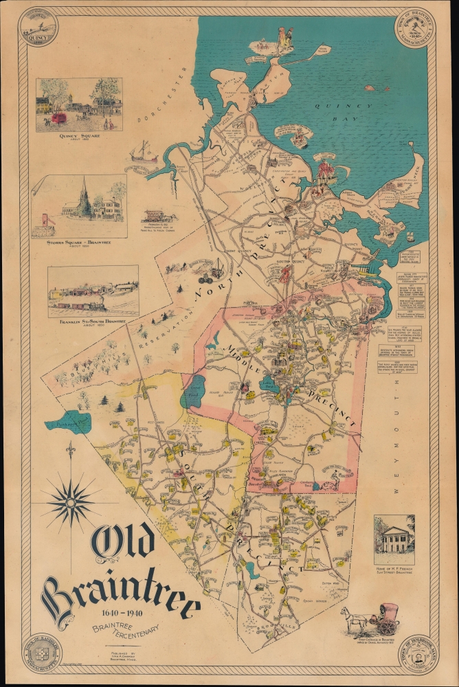
Old Braintree 1640-1940 Braintree Tricentennial.
1940 (dated) 20.5 x 12.75 in (52.07 x 32.385 cm) 1 : 42500
1940 (dated) 20.5 x 12.75 in (52.07 x 32.385 cm) 1 : 42500
Description
A scarce 1940 historical pictorial map of Old Braintree, Massachusetts, published by Ivan Chisholm for the tricentenary. It includes the modern towns of Braintree, Quincy, Randolph, and Holbrook, all situated just south of Boston, Massachusetts.
A Closer Look
The map covers the original boundaries of the town of Braintree, incorporated in 1640, including Quincy, Randolph, and Holbrook, which incorporated between the 1790s and 1870s (the borders between both colonial-era precincts and modern towns are displayed). Numerous illustrations represent historical sites and figures, local landmarks, and the area's culture. Early land grants and many individual homes have their owners labeled, along with businesses, schools, and churches. Additional illustrations portray scenes from 19th-century history, including the Granite Railway, arguably the first railroad in the United States. Rivers, creeks, lakes, hills, and other geographic features are also labeled.The Granite Railway
The Granite Railway in Massachusetts was one of the earliest commercial railways in the United States. It was built in 1826 to transport granite from quarries in Quincy, Massachusetts, to the Neponset River for shipment to various destinations, including Boston. Initially, it was a horse-drawn tramway rolling along steel-plated wooden rails, but it later adopted steam locomotives and steel rails. Over time, the railway instituted innovations that were later copied elsewhere. It also helped put Quincy on the map as a center for high-quality granite used in many notable buildings across the United States, including the Bunker Hill Monument in Charlestown.Old Braintree
The first European settlers in the area seen here were led by pirate captain Richard Wollaston (d. 1626) and his associate Thomas Morton, who established themselves at Ma-re-mount (or Merrymount) in 1624 - 1625. However, the antics of the mariners-turned-farmers, who lacked the Puritans' prudishness and freely took Native American women as wives and mistresses, scandalized the other English settlers, who had Morton arrested and sent back to England in 1627 (he returned to Massachusetts the following year and was promptly deported again). The area played an important role during the American Revolution and the early American Republic. Quincy, named for the grandfather of Abigail Adams, was the home of John Adams (and his son, John Quincy Adams), and (modern) Braintree produced John Hancock and Sylvanus Thayer, an early superintendent of West Point.Publication History and Census
This map was prepared and published by Ivan A. Chisholm in 1940 to coincide with the tricentenary of Braintree. It is rare. The OCLC identifies no holdings, and we are only aware of one other example appearing on the market.Cartographer
Ivan Alexander Chisholm (April 21, 1885 - 19??) was a Canadian American draftsman, engraver, surveyor, and civil engineer active in Boston. Born in Oxford, Nova Scotia, Canada, Chisholm appeared in the city directory of Quincy, Massachusetts, in 1908 and is listed as a civil engineer. By 1913, he had moved to Boston, where he was working as a draftsman for the Boston Transit Commission by 1914. During the 1930s and 1940s, Chisholm lived in Braintree, Massachusetts, but by the 1950s, he was back in Boston. More by this mapmaker...
Condition
Very good. 1-inch tear along right border professionally repaired.