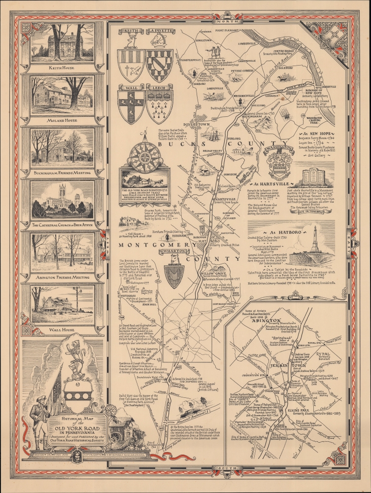
A charming, scarce 1941 historical pictorial map of the Pennsylvania Old York Road by Howard Kohlbrenner, produced for the Old York Road Historical Society.
A Closer Look
Coverage includes Montgomery and Bucks County in southeastern Pennsylvania, between Philadelphia and the Delaware River (also the border with New Jersey), which appears at top-right. Both historic and major modern roads are traced and labelled, including, of course, the historic Old York Road, as well as Pennsylvania Route 263, which largely follows this historic road. Extremely rich historical notes appear throughout on structures and sites ranging from the early days of colonial Pennsylvania to the late 19th century.
Included are the homes of prominent early families, Quaker meeting houses, churches, cemeteries, bridges, the sites of Revolutionary War actions, and more. An inset at bottom-right provides a closer view of the area around Abington and Jenkintown. The coats of arms of prominent early Pennsylvania families appear at left, along with illustrations of local landmarks. A lovely border and title cartouche provide additional embellishments to the map.The Old York Road
The Old York Road was originally an 18th century road build between New Hope, Pennsylvania on the Delaware River and Philadelphia, following an even older trail used by the Raritan (Lenape) people. After a crossing of the Delaware River, the route continued through New Jersey to New York City, providing for the first time a means of overland travel between the two cities by stagecoach. First conceived by William Penn in the late 17th century, the road was surveyed in 1711. Work was slow, with the road opening to New Hope in 1741, to New York City (or rather, Elizabethtown, New Jersey) in 1769, and only reaching downtown Philadelphia in 1771. Along with the Boston Post Road (also known as the Old Post Road) and other regional roads, the Old York Road effectively functioned as America's earliest highway network and spurred a range of economic activity. As the trip between New York and Philadelphia took two days, inns and taverns along the route were necessary. Competing stagecoach companies sprang up to vie over who could provide the fastest and most comfortable ride to their passengers.Publication History and Census
This pictorial map was designed and drawn by Howard Kohlbrenner for the Old York Road Historical Society in 1941, though the organization's records refer to an earlier, even rarer, printing of 1936. It is quite scarce, being listed among the holdings of the Wisconsin Historical Society and Swarthmore College. It presumably is also held by the Old York Road Historical Society itself.
Cartographer
Howard Kohlbrenner (November 28, 1897 - February 8, 1986) was a Philadelphia-based artist and art director for several publications. He attended the Philadelphia Museum College of Art and Pennsylvania Academy of Fine Arts. After working as an accountant in his early 20s, presumably while also practicing his own artistic works, from 1929 until the early 1970s, Kohlbrenner served as the At Director for the Chilton Company's Automotive Publications, including Automotive Industries and Motor Age. He took on a similar role with other publications by McGraw-Hill (which seems to have bought out Chilton) as well, such as Food Engineering and Aircraft and Missiles. Kohlbrenner was also deeply involved with the Old York Road Historical Society, designing the organization's logo in 1936 and serving for a time as an editor of the Old York Road Historical Society Bulletin. More by this mapmaker...
Very good. Three-inch tear on top-side border professionally repaired. A couple small spots of soiling towards top-right.
OCLC 854856692.