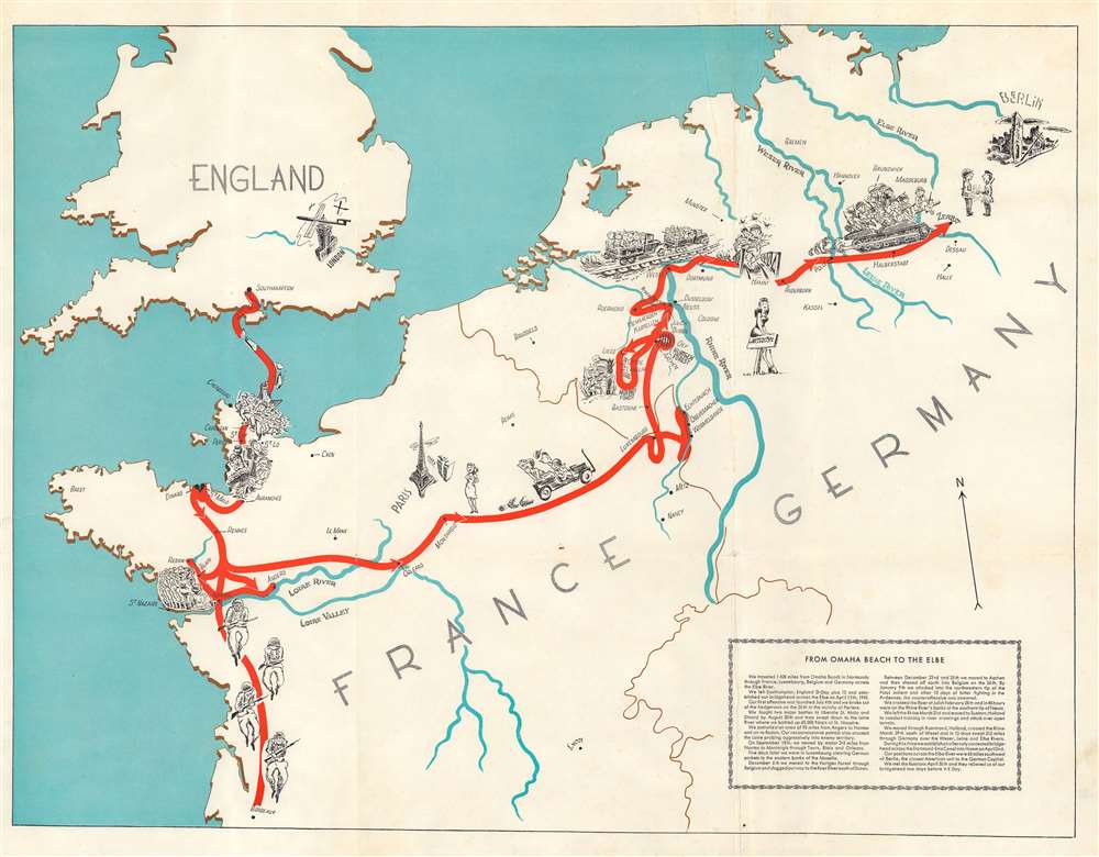
This is a 1945 World War II pictorial route map of western Europe illustrating the path forged by the 331st Combat Team. Following the unit from Southampton, England, to Zerbst, Germany (just across the Elbe River), pictorial vignettes highlight the combat team's experiences.
The 331st Combat Team in World War II
The 331st landed on Omaha Beach twelve days after D-Day and fought in the hedgerows in Normandy (both the landing and the hedgerow fighting are illustrated here). Once the Allied army broke out of Normandy, the 331st stormed south and helped sequester 60,000 German soldiers at St. Nazaire, a critical Atlantic port. This created the St. Nazaire pocket, which existed from August 1944 until May 11, 1945, and was patrolled by Free French and American forces. After St. Nazaire, the 331st was sent east across France (but not to Paris - see the GIs in a jeep staring longingly at Paris and its women) to Luxembourg and the Hurtgen Forest where they relieved the 4th Infantry Division. Fierce fighting ensued in the Hurtgen Forest and the 331st pushed the Germans to the Roer River south of Duren. Next came the famous Battle of the Bulge, which the 331st reached in late December and went on the offensive on January 9, 1945. Over the next ten days, the 331st advanced five miles in the bitter cold and deep snow, turning back the German advance. After Belgium, the 331st again turned east, and crossed the Roer and Rhine Rivers. With the 329th Combat Team, the 331st 'roared' 213 miles across Germany (illustrated by soldiers piled in the back of trucks and on top of tanks) and established a bridgehead across the Elbe River only sixty-five miles from Berlin, the closest American unit to the German capitol. The Russian Red Army met the 331st at their Elbe bridgehead on April 30th (marked by an illustration of an American and Russian soldier shaking hands) and relieved the 331st two days before V-E Day.World War II Route Maps
Maps tracing a unit's movements during World War II were created by American and British units both during and after the war. As a genre, these maps represent a wide range of aesthetics, from the purely functional that label places and provide dates, to the artistic, even comic. Many combine the two and provide a visually striking but historically informative summary of the unit's peregrinations.Publication History and Census
This map was likely drawn by Sergeant George Friedberg (although it is unsigned making this claim nearly impossible to verify) and was published by Sergeant Jack M. Straus in the 331st unit history We Saw it Through: History of the Three Thirty First Combat Team in 1945. The book and map were printed in Munich. The separate map is not cataloged in OCLC, but the unit history is well represented in institutional collections. The book is scarce on the private market.
Source
Straus, J. M., We Saw it Through: History of the Three Thirty First Combat Team. Today Tomorrow Forever, (Munich: Straus) 1945.
Good. Light foxing. Light creasing. Wear along original fold lines. Closed tear extending one (1) inch into printed area from left margin professionally repaired on verso.
OCLC 699603964 (book).