1933 E. Karolyn Ries Pictorial Map of the Oregon Territory
OregonCountry-ries-1933$1,600.00

Title
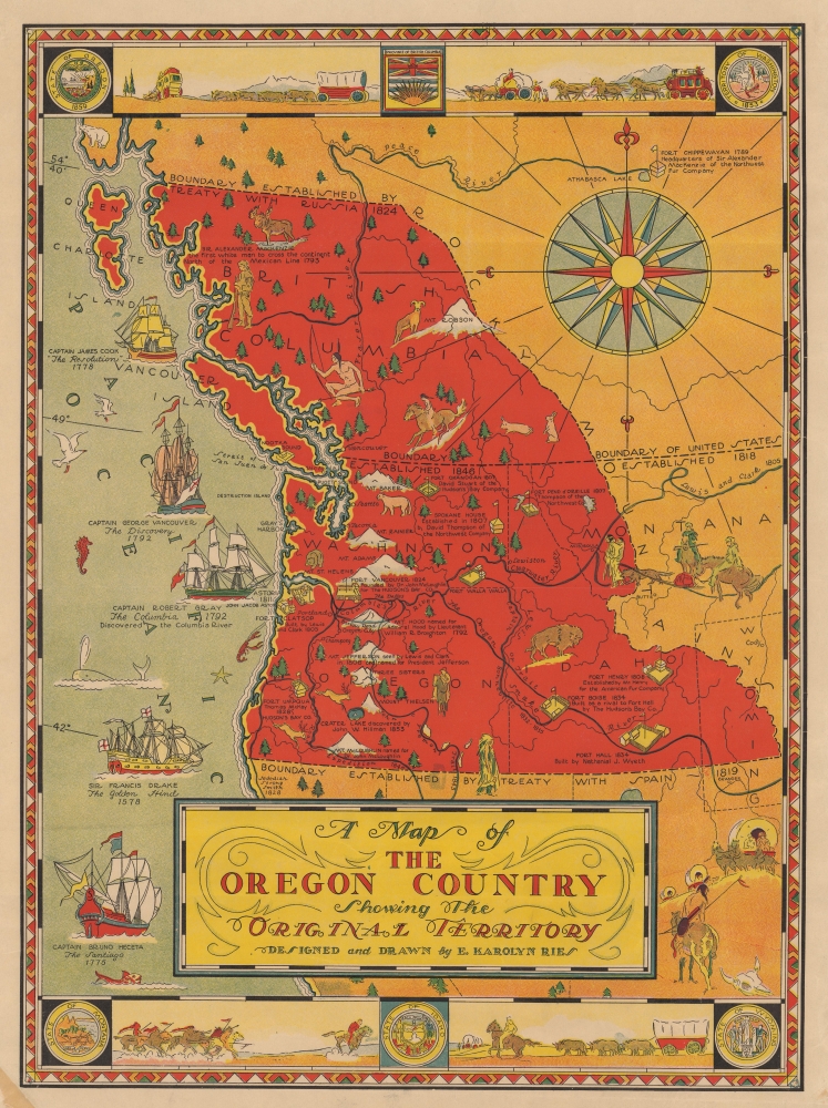
A Map of the Oregon Country Showing the Original Territory.
1933 (undated) 19.75 x 14.5 in (50.165 x 36.83 cm)
1933 (undated) 19.75 x 14.5 in (50.165 x 36.83 cm)
Description
This is a rare 1933 E. Karolyn Ries pictorial map of the Oregon Territory. The map combines artistic elements with references to American history, most specifically the Oregon Question (see below).
A Closer Look
The Oregon Territory appears here in red. Because of the history of exploration in the Pacific Northwest, some Americans believed that the northern boundary of the United States should extend to the 54°40' line of latitude. This boundary and the boundary set in 1846 are illustrated here. Mountains and rivers are prominently illustrated, including Mt. Rainier, Mt. St. Helens, and Mt. Hood. Pictorial illustrations of frontier forts also draw the viewer's attention; these are labeled, and many have a short history provided as well. Illustrations of Native Americans, mountain men, and the region's wildlife complete the image. Sailing ships from the Age of Sail appear in the Pacific and represent ships captained by the great explorers James Cook, George Vancouver, Robert Gray, Bruno Heceta, and Sir Francis Drake. Scenes from the Wild West, including covered wagons, a stagecoach, and a band of Native American warriors, occupy the border alongside the seals of Montana, Idaho, Wyoming, Oregon, Washington, and the Province of British Columbia.54-40 or Fight! American Claims to British Columbia
Following the transcontinental crossing of North America by the British Northwest Company sponsored explorer Alexander MacKenzie (1792 - 1793), and the American expedition of Lewis and Clark up the Missouri to the mouth of the Columbia River (1804 - 1806), it became apparent that control of the fur and resource-rich Pacific Northwest would bring great wealth and power to whoever could assert sovereignty. The American tycoon John Jacob Astor, with the permission of President Thomas Jefferson, was the first to attempt a permanent trading colony in the region, founding Astoria on the Columbia River in 1811. This quickly led to a confrontation with the established British-Canadian Northwest Company over this valuable territory. Americans in the 1820s through the 1840s argued that most of the Pacific Northwest should be part of the United States as a legacy of the 1803 Louisiana Purchase. England, on the other hand, argued for residual claims to the region derived from the MacKenzie Expedition and its fur trading empires: The Northwest Company and the Hudson Bay Company. The Oregon Dispute, as it came to be known, became an important geopolitical issue between the British Empire and the United States, especially after the War of 1812. Americans adopted the slogan '54-40 or Fight!' until the Oregon Question was finally resolved roughly along the current border by the 1846 Oregon Treaty.20th Century Pictorial Cartography
Pictorial qualities have been common in cartography from at least the 16th century when publishers like Braun and Hogenberg incorporated view-like qualities and other pictorial elements into their famous city plans. Braun and Hogenberg, and similar cartographers, issued their town books to express not necessarily the geography of their subjects but rather the 'essence' of the town/city. As mathematics and surveying principles advanced, travel increased, and the ability to translate two-dimensional cartographic perspectives into an understanding of the actual world became commonplace, maps themselves transformed. This trend is a recognizable progression that evolved cartographic conventions from the 17th to the 19th centuries. By the late 19th century, most maps had become geographical tools that illustrated the region cartographically but failed in the original raison d'être, as expressed by Braun and Hogenberg, to illustrate a place's 'essence.' So, where a city map of 19th-century Paris might provide a completely navigable presentation of the city, one could glean almost nothing of Paris' character from it. In the late 18th century, the first modern 'pictorial' style maps developed. These maps, like Tomas Lopez's 1788 map of Seville, attempted to provide both cartographic accuracy and pictorial elements that might convey the city's character. In that case, Lopez incorporated pictorial vignettes to illustrate important buildings and monuments. This style became increasingly common throughout the 19th and early 20th centuries, particularly for centers of commerce like London, Paris, and Rome, where they were often mass-produced and referred to as 'monumental' maps. The style further evolved in the early to mid-20th century, when revolutionary cartographers and illustrators like MacDonald Gill, Jo Mora, Frank Dorn, Ernest Dudley Chase, and many others combined vignette style illustrations, modern printing techniques, and inspiration from Japanese printmaking and manga and clever satirical cartographers/artists like Fred Rose, to produce maps that once again focused on revealing the essence a place, usually, but not always, at the sacrifice of cartographic precision.Publication History and Census
This map was drawn by E. Karolyn Ries and originally published by The Oregonian in March 1933 on the cover of its Sunday magazine, and it sold separate copies printed on heavy paper in the following weeks. The present example represents one of those separate copies. We note a cataloged example in OCLC, which is part of the collection at Yale University. Another example appeared on the private market in 2023.Cartographer
Ella Karolyn Ries (fl. c. 1930 - 1935) was a western illustrator and author who lived in Portland, Oregon, and was known professionally by the name E. Karolyn Ries. Ries gained fame through her children's stories and illustrations, which were eventually published internationally. In 1931 Ries operated her own art studios and held regular exhibitions of her and other artists' work. In 1932 Ries was named the director of the advertising and fashion art program at the Ellison White Conservatory. She was appointed the art director of the new public market in Portland in December 1933. She completed 'elaborate illustrations' to announce the market's opening. Ries also created children's illustrations that were published in The Oregonian beginning about 1928. In 1935 she changed jobs and accepted the position of art director for the Mary Pentland Advertising Agency and production manager for the agency's Seattle and Portland offices. By 1940 she and her husband Harris Van Alstyne Fleming, had moved to Los Angeles, California, where Ries was registered to vote. Her husband died in 1988, but we have not found any information concerning Ries' birth or death. More by this mapmaker...
Condition
Very good. Light soiling to margin. Closed margin tear professionally repaired on verso.
References
OCLC 54655877.