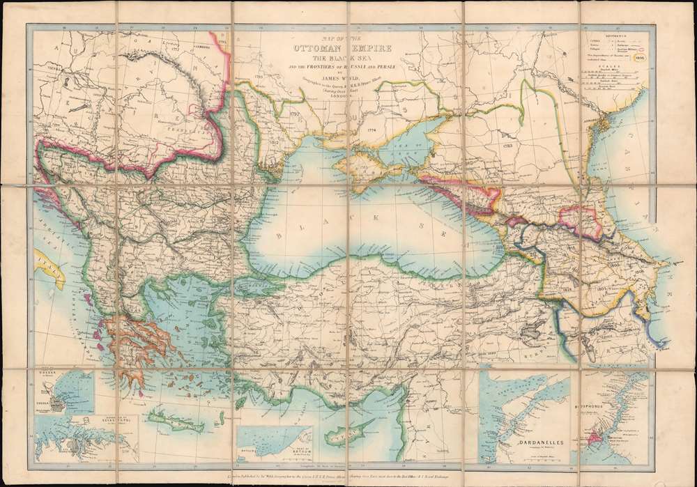
This is an 1853 James Wyld map of Turkey, the Balkans, and the Ottoman Empire at the outbreak of the Crimean War. Published less than a month after the beginning of the war, the map depicts the region from Vienna and the Adriatic Sea to the Caspian Sea and from Russia and Eastern Europe to Cyprus and Syria. Although the genesis of the Crimean War is unclear, one of the factors that led to the war was Russian expansion around the Black Sea. Here, Wyld highlights five regions to the north and east of the Black Sea that Russia gained between 1774 and 1812, including Crimea (still being fought over to this day) and Bessarabia. A printed notation in the eastern Black Sea reads, 'the Russians merely possess the Forts on this Coast.' A close reading of this infers that the Russians only hold the region's defenses, but do not have the loyalty of its people. An intriguing assertion, coming from a British source. Insets along the bottom border focus on some of the region's strategically important areas, including the Bosporus, the Dardanelles, and the Black Sea ports of Odessa, Sevastopol, and Batoum.
The Crimean War
The Crimean War, with an alliance of the Ottoman Empire, Britain, France, and Sardinia on one side of the conflict and the Russian Empire on the other, lasted from October 1853 until February 1856. The root cause of the war has never been fully understood. The stated impetus for hostilities was the rights of Christians in the Holy Land, with the Catholics being supported by the French and the Greek Orthodox Church, gaining the support of the Russians. Other factors also included the gradual decline of the Ottoman Empire and British and French concerns about Russian gains in the region at the cost of the Ottomans.
Hostilities erupted in July 1853 when Russia invaded two Ottoman suzerainties known collectively as the Danubian Principalities, labeled here as Wallachia and Moldavia. The Ottomans immediately responded and fought a defensive campaign that eventually halted the Russian advance at Silistra, which the Russians besieged. Alarmed by the possibility of an Ottoman collapse, the British and French jumped to their aid, sending troops and supplies to Gallipoli. They did not arrive at Silistra until after the Russians had withdrawn.
Now, public opinion at home, where discontent at the seemingly wasted effort and expense of sending armies to the Balkans, exerted an influence on the alliance. This outcry led to the planning and execution of an invasion of the Crimean Peninsula in September and a siege of the Russian naval port of Sevastopol, their primary naval base in the Black Sea, which lasted for eleven months. Russia finally sued for peace in March 1856, and in the Treaty of Paris the ended the war Russia lost its Black Sea ports, Wallachia and Moldavia gained a modicum of independence, and Christians in the Holy Land were given a degree of equality.Publication History and Census
This map was created and published by James Wyld and bears a copyright date of November 9th, 1853, less than a month after the beginning of the Crimean War. It is well represented in institutional collections.
Cartographer
James Wyld I (1790 - 1836) and his son James Wyld II (November 20, 1812 - 1887) were the principles of an English mapmaking dynasty active in London during much of the 19th century. The elder Wyld was a map publisher under William Faden and did considerable work on the Ordinance Survey. On Faden's retirement, Wyld took over Faden's workshop, acquiring many of his plates. Wyld's work can often be distinguished from his son's maps through his imprint, which he signed as 'Successor to Faden'. Following in his father's footsteps, the younger Wyld joined the Royal Geographical Society in 1830 at the tender age of 18. When his father died in 1836, James Wyld II was prepared to fully take over and expand his father's considerable cartographic enterprise. Like his father and Faden, Wyld II held the title of official Geographer to the Crown, in this case, Queen Victoria. In 1852, he moved operations from William Faden's old office at Charing Cross East (1837 - 1852) to a new, larger space at 475 Strand. Wyld II also chose to remove Faden's name from all of his updated map plates. Wyld II continued to update and republish both his father's work and the work of William Faden well into the late 1880s. One of Wyld's most eccentric and notable achievements is his 1851 construction of a globe 19 meters (60 feet) in diameter in the heart of Leicester Square, London. In the 1840s, Wyld also embarked upon a political career, being elected to parliament in 1847 and again in 1857. He died in 1887 following a prolific and distinguished career. After Wyld II's death, the family business was briefly taken over by James John Cooper Wyld (1844 - 1907), his son, who ran it from 1887 to 1893 before selling the business to Edward Stanford. All three Wylds are notable for producing, in addition to their atlas maps, short-run maps expounding upon important historical events - illustrating history as it was happening - among them are maps related to the California Gold Rush, the New South Wales Gold Rush, the Scramble for Africa, the Oregon Question, and more. More by this mapmaker...
Very good. Dissected and mounted on original linen, which has been reinforced in places. Folds into professionally restored original binder.
OCLC 49985028.