1789 De Wailly Map of Cité Quarter, Paris w/ Manuscript Proposal to unite Seine Islands
ParisCite-wailly-1789$7,500.00

Title
Plan du Quartier de la Cité. / Plan due Quartier de la Cité, de sa Reunion avec L'Isle St. Louis, d'une Garre et d'une Place Consacre a, Louis XVI.
1789 (undated) 12.25 x 24 in (31.115 x 60.96 cm)
1789 (undated) 12.25 x 24 in (31.115 x 60.96 cm)
Description
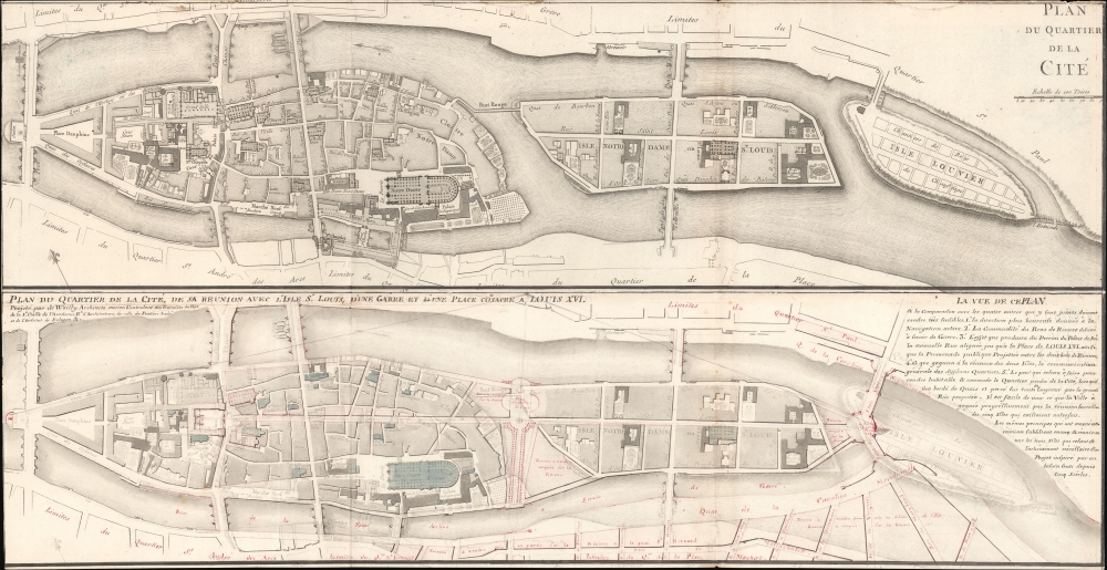
A most unique and intriguing 1789 map of the Cité quarter, Paris, with copious manuscript, illustrating the bold plan of French 'Architecte du Roi' and designer of the Odéon, Charles de Wailly, to unite Paris's Île de la Cité with neighboring Île Saint-Louis. The plan, though greeted at the 1789 Paris Salon with much enthusiasm, floundered due to unfortunate timing: it was proposed at the outbreak of the French Revolution (1789 - 1799). It is an epic 'could-have-been' by one of Paris's most famous and influential architects.
In the lower plan, De Wailly has abraded or washed away much of the printing and added his own manuscript in black, red, and blue ink. The process is consistent with De Wailly's only other surviving cartographic work, a general map of Paris illustrating a host of major civil engineering projects, including this one. In Boutier's cataloging of that map (#344), he describes the process as a reprinting in faint ink, but it is more likely that old ink was either abraded or bleached out to accommodate for De Wailly's manuscript revisions.
The project illustrated here was the keystone of De Wailly's plans for Paris, a full restructuring of the oldest part of Paris, the Cité Quarter, removing the entirety of Île Louvier, and merging the Île de la Cité with the Île Saint-Louis. He adds grand plazas, new buildings, and a host of new streets, including a broad boulevard cutting through the center of Île de la Cité. Île Saint-Louis was to be expanded with a plaza and new bridges partially overlapping the former Île Louvier. Many of these changes are dedicated to De Wailly's royal patron, Louis XVI - a most unfortuitous relationship given the contemporaneous outbreak of the French Revolution (1789 - 1799).
De Wailly's plan, reflecting the general map of Paris held at the BnF, was introduced in 1789 at the Salon de Louvre. It was the first comprehensive plan for a major city-wide restructuring, incorporating diverse renovations for multiple neighborhoods. The present map focuses specifically on De Wailly's proposals for the Cité Quarter.
De Wailly's was not the first proposal to unite the islands. As De Wailly states on this very map, this was a 'Projet inspire par un besoin sent despuis Cinqu Siěcles'. The architect Pierre Patte (1732 - 1814) presented a different plan to unite the islands c. 1772, but his work involved the complete demolition of all existing structures on Cité, including Notre Dame, and thus never gained momentum. As illustrated here, De Wailly's plan was a major improvement over earlier models and practical, retaining beloved historical buildings while modernizing navigability and public space.
In the August 17, 1789 proceedings of the Académie Royale d'Architecture, De Wailly's plan is described with aplomb, and there is little doubt they are referring to this exact map or a copy,
A Closer Look
The map consists of two examples of the 1772-74 Jaillot / Perrier Plan du Quartier de la Cité, trimmed and joined, one above the other, almost certainty by De Wailly. Oriented to the north-northwest, the upper plan details the islands as they existed in the mid-18th century based upon the Turgot-Bretez Plan.In the lower plan, De Wailly has abraded or washed away much of the printing and added his own manuscript in black, red, and blue ink. The process is consistent with De Wailly's only other surviving cartographic work, a general map of Paris illustrating a host of major civil engineering projects, including this one. In Boutier's cataloging of that map (#344), he describes the process as a reprinting in faint ink, but it is more likely that old ink was either abraded or bleached out to accommodate for De Wailly's manuscript revisions.
The project illustrated here was the keystone of De Wailly's plans for Paris, a full restructuring of the oldest part of Paris, the Cité Quarter, removing the entirety of Île Louvier, and merging the Île de la Cité with the Île Saint-Louis. He adds grand plazas, new buildings, and a host of new streets, including a broad boulevard cutting through the center of Île de la Cité. Île Saint-Louis was to be expanded with a plaza and new bridges partially overlapping the former Île Louvier. Many of these changes are dedicated to De Wailly's royal patron, Louis XVI - a most unfortuitous relationship given the contemporaneous outbreak of the French Revolution (1789 - 1799).
De Wailly's Plans for Paris
Paris of the mid-18th century was built piecemeal following multiple often conflicting interests, sometimes simply following the terrain without a central plan. Parisians were frustrated by the claustrophobic maze of haphazard streets and demanded modernization. Luminaries no less than Descartes and Voltaire weighed in on the question. Royally sponsored conferences held between 1740 and 1770 yielded several embellissment recommendations and recorded the demands of Parisians for a more gracious and navigable city. While these proposals have not been studied systematically, they reflect the progression toward a comprehensive urban planning scheme.De Wailly's plan, reflecting the general map of Paris held at the BnF, was introduced in 1789 at the Salon de Louvre. It was the first comprehensive plan for a major city-wide restructuring, incorporating diverse renovations for multiple neighborhoods. The present map focuses specifically on De Wailly's proposals for the Cité Quarter.
De Wailly's was not the first proposal to unite the islands. As De Wailly states on this very map, this was a 'Projet inspire par un besoin sent despuis Cinqu Siěcles'. The architect Pierre Patte (1732 - 1814) presented a different plan to unite the islands c. 1772, but his work involved the complete demolition of all existing structures on Cité, including Notre Dame, and thus never gained momentum. As illustrated here, De Wailly's plan was a major improvement over earlier models and practical, retaining beloved historical buildings while modernizing navigability and public space.
In the August 17, 1789 proceedings of the Académie Royale d'Architecture, De Wailly's plan is described with aplomb, and there is little doubt they are referring to this exact map or a copy,
L’Académie étant assemblée, M. De Wailly a présenté un plan de la réunion du quartier de la Cité aux îles Saint Louis et Louvier : ce projet, déjà approuvé par l’Académie des sciences et reconnu par elle très utile, présente celui d’une grande place érigée à la gloire de Louis XVI sur des voûtes qui couvriroient la rivière de Seine entre le Pont au Change et le Pont Notre Dame. L’Académie, qui a suspendu ses réflexions sur l’utilité entière de ce projet, n’a pu qu’applaudir à la grandeur de l’idée et aux études faites par l’académicien pour prouver la possibilité de son exécution.De Wailly's plans for Paris were publically presented at the 1789 Salon and appeared in the Livret du Salon de Louvre de 1789 (nos. 56-57). They were received with great fanfare, but their timing could have been better. As they were being exhibited, the French Revolution (1789 - 1799) broke out with the July 14 Storming of the Bastille. While the National Assembly and the King maintained a tentative truce for a time, the appetite for grand, royally sanctioned urban renewal projects dimmed considerably. Despite the Revolutionary fervor taking the country, De Wailly did not give up. In 1791, an anomyme plan was presented to the Paris Commune to unite the islands on a very similar model … a coincidence? Ultimately, Paris did not see its much-needed modernization until Napoleon III sponsored the Haussmann Renovations in the mid-19th century.
[The Academy being assembled, Mr. De Wailly presented a plan for the unification of the Cité district with the Saint Louis and Louvier islands: this project, already approved by the Academy of Sciences and recognized by it as very useful, presents the idea of a large square erected to the glory of Louis XVI on vaults that would cover the Seine River between the Pont au Change and the Pont Notre Dame. The Academy, which suspended its reflections on the overall usefulness of this project, could only applaud the grandeur of the idea and the studies carried out by the academician to prove the feasibility of its execution.]
Publication History and Census
These maps were published c. 1772-74 by Alexis Hubert Jaillot (cf. Boutier #302) as part of a compiled collection of plans encompassing the 20 quarters of Paris, for which it was Plan 1. We are aware of four surviving examples of this map at French institutions. The present map, however, is more of a constructed piece. It features two copies of the Jaillot Plan de Quartier de la Cité, joined and trimmed. The lower plan has much of the original printing bleached or abraded off, although a ghost image remains evident. De Wailly's extensive manuscript plans are added in black, red, and blue ink. This is one of just two surviving De Wailly urban planning maps - the other exhibits a similar construction method and is the aforementioned general plan of Paris located in the BnF. This is a one-of-a-kind treasure for the serious Paris collector.CartographerS
Charles de Wailly (November 9, 1730 - November 2, 1798) was a French architect, civil engineer, and painter, known for his late 18th century neoclassical architecture in and around Paris. Born in Paris, he trained under leading architects of his time and became a member of the prestigious Académie Royale d'Architecture. De Wailly was a key figure in the neoclassical movement, influencing French architecture with a refined sense of proportion and classical form. His notable works include the Théâtre de l’Odéon and renovations of Château de Fontainebleau. He is less well known for his grandiose urban planning visions, likely because none of them came to fruition. De Wailly envisioned a sweeping transformation of the Parisian landscape intended not only to beautify Paris but also to optimize the efficiency of its urban space. His visions included the creation of wide new avenues, the construction of public squares, the erection of monuments, the expansion of housing, the unification of the city’s islands (Cité, Saint-Louis, and Louviers), and improvements to the flow of the Seine. These were presented and met with approval at the Salon of 1789, and may have gone forward, but De Wailly had terrible timing - the troubles later that year (the onset of the French Revolution) put an end to Louis XVI's royal investment in, well, anything. More by this mapmaker...
Alexis-Hubert Jaillot (c. 1632 - 1712) followed Nicholas Sanson (1600 - 1667) and his descendants in ushering in the great age of French Cartography in the late 17th and 18th century. The publishing center of the cartographic world gradually transitioned from Amsterdam to Paris following the disastrous inferno that destroyed the preeminent Blaeu firm in 1672. Hubert Jaillot was born in Franche-Comte and trained as a sculptor. When he married the daughter of the Enlumineur de la Reine, Nicholas I Berey (1610 - 1665), he found himself positioned to inherit a lucrative map and print publishing firm. When Nicholas Sanson, the premier French cartographer of the day, died, Jaillot negotiated with his heirs, particularly Guillaume Sanson (1633 - 1703), to republish much of Sanson's work. Though not a cartographer himself, Jaillot's access to the Sanson plates enabled him to publish numerous maps and atlases with only slight modifications and updates to the plates. As a sculptor and an artist, Jaillot's maps were particularly admired for their elaborate and meaningful allegorical cartouches and other decorative elements. Jaillot used his allegorical cartouche work to extol the virtues of the Sun King Louis IV, and his military and political triumphs. These earned him the patronage of the French crown who used his maps in the tutoring of the young Dauphin. In 1686, he was awarded the title of Geographe du Roi, bearing with it significant prestige and the yearly stipend of 600 Livres. Jaillot was one of the last French map makers to acquire this title. Louis XV, after taking the throne, replaced the position with the more prestigious and singular title of Premier Geographe du Roi. Jaillot died in Paris in 1712. His most important work was his 1693 Le Neptune Francois. Jalliot was succeeded by his son, Bernard-Jean-Hyacinthe Jaillot (1673 - 1739), grandson, Bernard-Antoine Jaillot (???? – 1749), and the latter's brother-in-law, Jean Baptiste-Michel Renou de Chauvigné-Jaillot (1710 - 1780). Learn More...
Condition
Good. Trimmed to neatline. Some older verso reinforcement. Slight loss reinstated along top margin. Mild foxing. Extensive manuscript annotation in red ink.
References
cf. Carnavalet Museum, History of Paris, 320290209, 320290202. cf. Library of Congress, 2021668417. cf. Bibliothèque nationale de France, département Cartes et plans, GE C-4384 (RES).