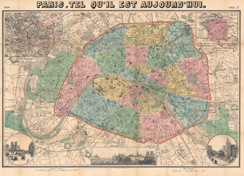
1900 Joly City Plan or Map of Paris, France: 1900 Exposition Universelle
ParisExpo-joly-1900$650.00


Title
Paris, tel qu'il est aujourd'hui.
1900 (dated) 23.5 x 32.25 in (59.69 x 81.915 cm) 1 : 15000
1900 (dated) 23.5 x 32.25 in (59.69 x 81.915 cm) 1 : 15000
Description
This is a 1900 L. Joly city plan or map of Paris highlighting the 1900 Exposition Universelle. The Exposition began a new global era of technological innovation and social change.
This map highlights Paris's other iconic monuments as well: the Louvre, the Arce de Triomphe, the Palais Royale, Notre Dame, and the Opera are all labeled. Famous parks, including the Jardin des Tuileries, the Jardin du Luxembourg, the Jardin des Plantes, and the Parc des Buttes Chaumont are all shaded green. At this time, Paris was surrounded by the massive Thiers Wall and its atendent fortifications.
An inset in the upper left expands coverage to the Paris environs. In the upper right, a second inset details the French railroad network. Three views line the bottom border, from left: Notre Dame and the Seine, a general view of the city, and some of the Exposition buildings.
A Closer Look
Beginning with the Exposition Universelle, the Château d'eau and the Salle des Fêtes are prominently illustrated on the Champ de Mars opposite the Eiffel Tower. Across the Seine, the Palais du Trocadéro appears. From there, the Exposition's pavilions extend along the Seine to the Pont Alexandre III. The pavilions dedicated to the participating nations line the left bank, while the 'Vieux Paris' attraction and other pavilions occupy the right bank. The Grand Palais and Petit Palais appear on the right bank between the Pont Alexandre III and the Champs-Elysées. Other pavilions occupy the Esplanade des Invalides.This map highlights Paris's other iconic monuments as well: the Louvre, the Arce de Triomphe, the Palais Royale, Notre Dame, and the Opera are all labeled. Famous parks, including the Jardin des Tuileries, the Jardin du Luxembourg, the Jardin des Plantes, and the Parc des Buttes Chaumont are all shaded green. At this time, Paris was surrounded by the massive Thiers Wall and its atendent fortifications.
An inset in the upper left expands coverage to the Paris environs. In the upper right, a second inset details the French railroad network. Three views line the bottom border, from left: Notre Dame and the Seine, a general view of the city, and some of the Exposition buildings.
1900 Exposition UNierselle
he 1900 Exposition Universelle, held in Paris, was a grand showcase of the achievements of the 19th century and a celebration of the dawn of a new era. Spanning from April to November, this world's fair highlighted the technological innovations, artistic accomplishments, and cultural diversity of the participating nations. Among its many attractions were the debut of the Grande Roue de Paris (a giant Ferris wheel), the first-ever moving sidewalk, and the stunning Petit and Grand Palais, which hosted exhibitions of fine arts and industrial advancements. Drawing over 50 million visitors, the Exposition Universelle left an indelible mark on the early 20th century, symbolizing hope, innovation, and international collaboration.Publication History and Census
This map was edited and published by L. Joly in 1900. This is the only verifiable example of the present edition. A map published in 1900 by L. Joly is part of the collection at the Bibliothèque historique de la Ville de Paris, but it has not yet been digitized, and we have not been able to confirm whether it is the same edition. We believe the scales differ between the present example and the one held by the Bibliothèque historique de la Ville de Paris.Condition
Good. Wear and toning along original fold lines. Verso repairs to fold separations. Soiling on verso not evident on recto. Some damage where previously attached to binder along left border.