1762 Georges-Louis Le Rouge Map of Acadia/ Nova Scotia in its First State
PartieOrientaleDuCanada-lerouge-1762$2,850.00

Title
Partie Occidentale du Canada.
1762 (dated) 19.75 x 24 in (50.165 x 60.96 cm) 1 : 1950000
1762 (dated) 19.75 x 24 in (50.165 x 60.96 cm) 1 : 1950000
Description
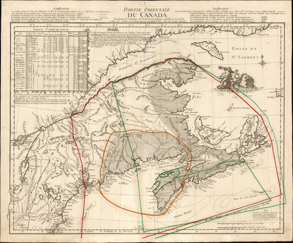
This is the 1762 first state of Georges-Louis Le Rouge's scarce, informative map of maritime Canada, Nova Scotia, and New England. It details conflicting French and English territorial claims, particularly in Acadia. Although its topography is derived from Thomas Jefferys' 1755 A New Map of Nova Scotia, Le Rouge marshals a wealth of detail not present in that source in order to focus on international territorial concerns.
Le Rouge consulted a wide array of sources and includes in the upper left a comparative table showing the varied measurements of 24 locations given on eight maps, as well as the present work. The map seems to have been intended for a broad, international audience: in addition to the mapmaker's French, there is an explanation of the work included in German.
A Closer Look
The map focuses particularly on the portion of Canada south of the opening of the St. Lawrence River; it reaches from the southern Labrador coast to as far south as Boston. Its western limits are Montreal and the Hudson River; it extends as far east as Cap Raye of Newfoundland and includes Nova Scotia and Cape Breton Island, here termed Isle Royale. While predominantly a functional, data-rich work, the map also enjoys the decorative flourish of a beautifully engraved Neptune riding a sea chariot.A History of Conflict
The map was produced during the French and Indian War (1754 - 1763), but it draws on a long history of Canadian territorial complaints between the English and French. The map presents the changing political boundaries as far back as 1638. Hachures indicate the feudal domains of the French nobles Charnisay and La Tour, who fought a war over control of the coast until 1650. It also marks the area granted to La Tour to govern on behalf of Cromwell's England in 1656, compared with the territory ceded to England in 1713. These borders are presented with a decided French slant, minimizing the regions granted to the English by the less-than-precise Treaty of Utrecht. The 1748 Treaty of Aix-La-Chapelle, having settled the boundary of Acadia to nobody's satisfaction following King George's War (1744 - 1748), necessitated further commissions to measure the border, resulting in the 1751 lines indicated on the map. Matters had not been resolved by the start of the French and Indian War, but the Treaty of Paris would effectively erase Acadia from the map and render the issue moot.Le Rouge consulted a wide array of sources and includes in the upper left a comparative table showing the varied measurements of 24 locations given on eight maps, as well as the present work. The map seems to have been intended for a broad, international audience: in addition to the mapmaker's French, there is an explanation of the work included in German.
Publication History and Census
The dating of this map in both the literature and among institutional collections is indecisive. This map was produced for inclusion in Le Rouge's 1762 Atlas General contenant le detail des Quatre Parties du Monde. (The often-cited 1755 date on the map refers not to the publication of this map but to the Jefferys map upon which it is based.) A second state of the map, entitled 'Nouvelle Ecosse, ou partie orientale du Canada,' appeared in the 1778 edition of the Atlas General as well as Le Rouge's new Atlas Ameriquain. We see a handful of examples of this first state of the separate map in institutional collections.CartographerS
Georges-Louis Le Rouge (c. 1707 - c. 1790) was a Paris based map publisher operating in the middle part of the 18th century. Le Rouge was born in Hanover Germany as Georg Ludwig, where he was educated and employed as a military engineer and surveyor. His father may have been the French architect Louis Remy de la Fosse (1659 - 1726), which would explain his early education in both engineering and draftsmanship. He assisted his father on a large-scale plan of Darmstadt, which he completed following his father's death in 1726. He may have remained in Darmstadt, but little is known of his life from 1726 - 1736, when he appears in Paris. Le Rouge acquired a position as military and civil engineer for King Louis XV and Louis XVI. Around this time, he Francophied his name to 'Le Rouge'. In 1840, he set up shop on the Rue Des Grands Augustins as an engraver, book publisher, and map publisher. He partnered with the English cartographer and engineer John Rocque (1709 - 1762), who became an important source for English maps, which Le Rouge re-engraved for French use. Despite being born German and adopting Paris as his home, Le Rouge was an ardent Anglophile and spent much of his time translating English books and maps into French. During his active period of roughly forty years Le Rouge produced thousands of maps and diagrams ranging from city and town plans, to atlases, plans of military campaigns and sea charts. He was a friend and correspondent of Benjamin Franklin (1706 - 1790), with whom he produced the important 1769 Franklin/Folger Map of the Gulf Stream. Franklin, who met Le Rouge in Paris, writes that 'He [Le Rouge] is, I believe, a proper person.' He was awarded for his diligence with the impressive but unstipended honorific 'Geographe du Roi'. They may not have served him swell during the French Revolution (1789 - 1799), as his last known work was published in 1789, just before the storming of the Bastille. The exact date of Le Rouge's death remains a mystery. By most estimates, he is believed to have been alive in 1790, but may have lived as long as 1794. More by this mapmaker...
Thomas Jefferys (1695 - November 20, 1771) was one of the most prominent and prolific map publishers and engravers of his day. Jefferys was born in Birmingham and was apprenticed to the engraver Emmanuel Bowen in 1735. Later, in the 1740s he engraved several maps for the popular periodical Gentleman's Magazine. Around 1740 Jefferys was finally able to go into business for himself and in 1746 received an appointment as 'Geographer to Fredrick, Prince of Wales,' which shortly after translated to the position of 'Royal Cartographer to King George III.' Jefferys initially specialized in compiling and re-engraving the works of earlier cartographers into more coherent cartographic wholes. Later, while not salaried position, Jefferys' appointment as 'Royal Cartographer' guaranteed preferential access to the most up to date cartographic material available, allowing him to produce new and updated charts of exceptional accuracy. He his best known for his maps of the Americas, particularly the posthumously published 1775 American Atlas, which included some of the finest and most important late colonial era maps of America ever made. Despite his prolific publishing history, royal appointments, and international publishing fame, Jefferys lived most of his life in dire economic straits. He was bailed out of bankruptcy by Robert Sayer during the production of the American Atlas. In the end, Jefferys died suddenly with very little to his name. Nonetheless, his cartographic legacy survived, and even after his death in 1771, many of his important maps continued to be published and republished by Sayer and Bennet, Conrad Lotter, Georges Louis Le Rouge, Laurie and Whittle, and others. Many attribute some of Jefferys best maps to the colorful and criminally inclined Irish cartographic genius Braddock Mead (John Green, c. 1688 - 1757), who is considered the 'secret behind Jefferys.' Jefferys was succeeded by his son, also Thomas, who had little success as a cartographer and eventually partnered with, then sold his stock and plates to William Faden - Jefferys' true heir. Learn More...
Source
Le Rouge, G-L., Atlas General contenant le detail des Quatre Parties du Monde, (Paris: Le Rouge) 1762.
Condition
Very good. One marginal mend at bottom just entering border; else an excellent example with original outline color.
References
OCLC 5408226. Kershaw, K. A., Early Printed Maps of Canada, #741 State one.