1909 Rock Map of Pasadena, California, with Altadena, South Pasadena, and Alhambra
Pasadena-rock-1909
Title
Map of Pasadena.
1909 (dated)
20 x 13.25 in (50.8 x 33.655 cm)
1 : 24000
Description
A 1909 map of Pasadena, California and surrounding communities (Altadena, South Pasadena, Alhambra) by George Rock. It displays the city at an important point in its history, as it expanded rapidly, becoming renowned as an idyllic retreat from Los Angeles and points much farther afield.
A Closer Look
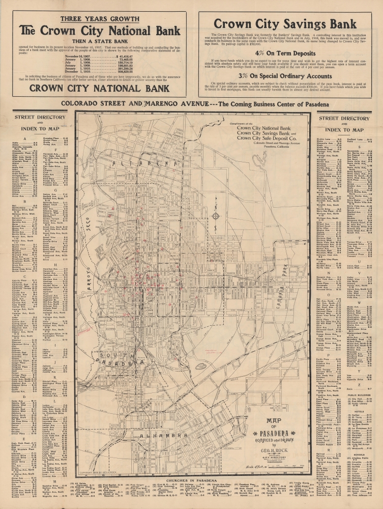
Coverage extends from the Arroyo Seco in the west to the neighborhood of Lamanda Park, and north from the San Gabriels to Alhambra in the south. Concentric circles denote distance at half-mile intervals from Pasadena's City Hall, not far from the present, recognizable structure completed in 1927. A grid surrounds the map corresponding to an index of street names, with additional indexes of public buildings, hotels, schools, and churches (numbered on the map) at bottom. Nearby golf courses are also indicated with red text. Handwritten annotations, seemingly related to real estate prices, appear at right near Lamanda Park.
In addition to Southern Pacific lines, rail lines shown here include the 'Santa Fe R.R.' (Atchison, Topeka and Santa Fe Railway) and the 'Salt Lake R.R.' (Los Angeles and Salt Lake Railroad). Though not indicated as such, the white and black alternating lines are streetcar lines belonging to the Pacific Electric Railway. Today, the Light Rail 'L' Line of the LA Metro uses the previous Atchison, Topeka and Santa Fe line. Crown City National Bank
At top are advertisements for the Crown City National Bank, the Crown City Savings Bank and the Crown City Safe Deposit Co. The claim that the intersection of Colorado St. and Marengo Ave. was the 'Coming business center of Pasadena' proved prescient, but the bank itself was less enduring, going through a rapid series of acquisitions ending with its being absorbed by the Los Angeles-based Security Trust and Savings.Verso Content
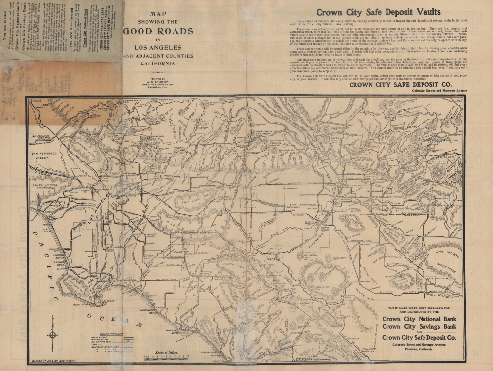
The verso displays a fascinating road map covering much of today's Los Angeles metro area, from Santa Monica and the San Fernando Valley as far south as Laguna Beach along the coast and as far east as Oak Glen and San Jacinto. Mountain peaks are named with their elevations recorded. It is notable for the inclusion of 'wagon roads' and trails (especially in the mountains) in addition to 'good roads.' The naming and indication of boundaries of cities is also significant, as some well-known municipalities, such as Beverly Hills (here as just 'Beverly'), hardly existed at this time, while others, such as Sawtelle and Watts, were later incorporated into Los Angeles. Taken as a whole, the verso map is a reminder that what we think of Los Angeles today was at this time a set of discontinuous and somewhat distant towns and cities which were progressively linked together by railroads, roads, highways, and suburban sprawl over the course of the 20th century. Paradise at the Foot of the San Gabriels
The Los Angeles and San Gabriel Valley Railroad was constructed with the aim of connecting Pasadena with Los Angeles and began service in 1885. Soon afterwards, it was acquired by the Atchison, Topeka and Santa Fe Railway and connected to the latter's existing network, which opened the small town to visitors and travelers from across the continent. Around the same time, the area developed a reputation as being home to the ideal climate for convalescence, especially for asthmatics and tuberculosis patients. Very quickly, with the help of effective boosterism by local businesses, Pasadena's reputation as a Mediterranean-style resort town spread, and opulent hotels and other services catering to tourists from the eastern United States sprung up in rapid succession. The Mount Lowe Railway and other attractions catering to tourists became a destination in themselves. From less than 5,000 residents in 1890, the city had grown to more than 30,000 residents by 1910. The city center highlighted here, now known as 'Old Pasadena,' took on a highly distinctive architectural (Mediterranean Revival and Spanish Colonial Revival) and urban planning style in the following decades.Publication History and Census
This map was drawn and compiled by George H. Rock and published by A. G. Thurston for the local Crown City National Bank / Crown City Savings Bank in 1909. Two variations dated to 1909 exist in addition to the present map: one without an index and including an advertisement for unnamed 'Home Builders' (OCLC 1143765107), and another (held by the Beinecke Library at Yale University) with the present format but with advertisements for real estate and investment bankers instead of Crown City National Bank. Editions of the map from 1912 and 1913 also exist, in the latter case (held by the Huntington Library) also including advertisements for Crown City National Bank. The verso map was also separately issued by Rock and Thurston in 1909 as 'Map of Los Angeles and Adjacent Counties.' All of these maps are quite rare, and the present map is the only known example of the 1909 edition with this configuration of index and advertising, the closest match being the 1913 edition issued for Crown City National Bank held by the Huntington Library.
Condition
Good. Splits and wear along fold lines and at fold intersections professionally repaired on verso. Original cover attached.
References
OCLC 1143765107 (variant edition).