This item has been sold, but you can get on the Waitlist to be notified if another example becomes available, or purchase a digital scan.
1885 Escuela de Artes Map of the Paso de Quinteros, Uruguay
PasoDeQuinteros-escueladeartes-1885$750.00

Title
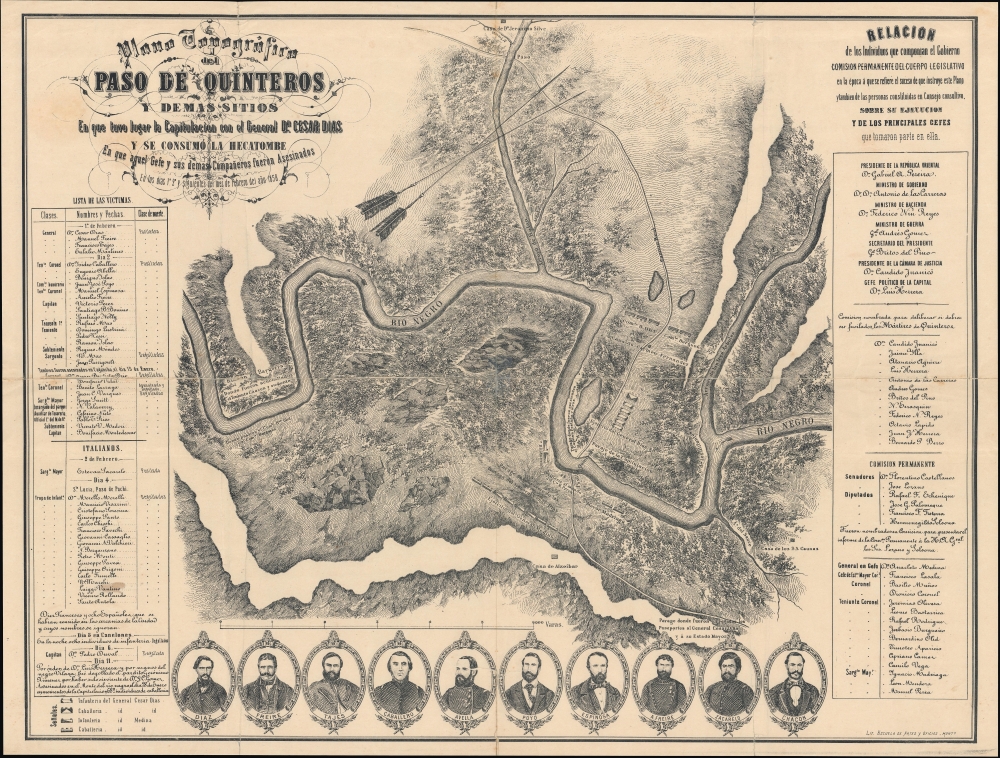
Plano topográfico del Paso de Quinteros y demás sitios en que tuvo lugar la capitulación del Gral. César Díaz y se consumó la hecatombe en que aquel Gefe y sus demás compañeros fueron asesinados en los días 1 y 2 y siguientes del mes de febrero del año 1858.
1885 (undated) 21 x 27.5 in (53.34 x 69.85 cm) 1 : 22050
1885 (undated) 21 x 27.5 in (53.34 x 69.85 cm) 1 : 22050
Description
A richly detailed c. 1885 historical map of the Paso de Quinteros along the Rio Negro in Uruguay, produced by the Escuela de Artes y Oficios. It commemorates a massacre that took place there in 1858, following an uprising the previous year, an episode in a decades-long Uruguayan Civil War.
The battle and massacre at Paso de Quinteros occurred soon afterward. The Colorado general César Díaz had tried to capture Montevideo in early January 1858 but failed and was forced to retreat. After being defeated in a battle near the Cagancha stream, Díaz and the remnant Colorado forces were cornered at the Paso de Quinteros along the Rio Negro. Díaz and 150 of his officers were convinced to surrender on the promise that their lives would be spared. However, they were executed in the Paso de Quinteros on February 1 and 2 on the orders of President Gabriel Antonio Pereira, who hoped to avert a return to full-scale civil war. Pereira's plan worked briefly, and for several years, his 'fusionist' agenda (aiming to overcome the Blanco-Colorado divide) brought stability and prosperity to Uruguay, especially under his successor, Bernardo Prudencio Berro (President from 1860 - 1864). Nonetheless, by 1863, this had broken down, and Uruguay was again embroiled in civil war.
A Closer Look
Oriented towards the northwest, the map covers the Paso de Quinteros along a bend in the Rio Negro, where it is joined by the Arroyo de Rolon and several other small tributaries. Roads, houses, and troop encampments are marked. At left is a list of the most prominent victims of the massacre, including their rank, method of execution, and nationality (a significant portion of the contingent were Italians, comrades of the revolutionary Giuseppe Garibaldi), with portraits of the executed leaders of the rebellion appearing at the bottom. A legend at bottom-left provides an explanation of the forces under César Díaz, the commander of the rebel Colorado forces. At right is a list of leading figures in the government and military forces fighting the uprising.The Uruguayan Revolution of 1858
The Uruguayan Revolution of 1858 was typical of civil wars of 19th century South America, pitting a faction of 'whites' or Blancos against 'reds' or Colorados, who battled over issues relating to the relative power of the central and local governments. These tensions dated to the earliest days of Uruguay's struggle for independence from Spain and had already resulted in a protracted civil war from 1839 to 1851. Unfortunately, even this long conflict did not settle the dispute. As is often the case with civil wars, external powers became involved, with the Colorados supported by Brazil (as well as Britain, France, and Italian revolutionaries) and the Blancos backed by Argentina. Although a tenuous peace had been maintained for much of the 1850s, it proved to be a pause rather than an end to the civil war, which reignited with a December 1857 uprising by the Colorado faction.The battle and massacre at Paso de Quinteros occurred soon afterward. The Colorado general César Díaz had tried to capture Montevideo in early January 1858 but failed and was forced to retreat. After being defeated in a battle near the Cagancha stream, Díaz and the remnant Colorado forces were cornered at the Paso de Quinteros along the Rio Negro. Díaz and 150 of his officers were convinced to surrender on the promise that their lives would be spared. However, they were executed in the Paso de Quinteros on February 1 and 2 on the orders of President Gabriel Antonio Pereira, who hoped to avert a return to full-scale civil war. Pereira's plan worked briefly, and for several years, his 'fusionist' agenda (aiming to overcome the Blanco-Colorado divide) brought stability and prosperity to Uruguay, especially under his successor, Bernardo Prudencio Berro (President from 1860 - 1864). Nonetheless, by 1863, this had broken down, and Uruguay was again embroiled in civil war.
Publication History and Census
This map was lithographed by Escuela de Artes y Oficios around the year 1885 (a very tentative estimate based on the most active years of the Escuela). We are unaware of any examples in institutional collections. However, the Biblioteca Nacional de Uruguay holds what appears to be a later variant printing published c. 1900 in the periodical Ecos del Progreso.Cartographer
La Escuela de Artes Y Oficios (1878 - 1887) was a school developed in Montevideo, Uruguay, as part of that country's modernization process, both as an instrument of education and of social control. It was founded on December 31, 1878, during the presidency of Lorenzo Latorre. At that time it was located within a military compound and was administered directly by the Ministry of War: its students were young people detained by the police or the army. These were taught to read, and instructed in a trade during their detention. Printing - both letterpress and lithography - appear to have numbered among these trades: the school published an array of works during its existence, ranging from books of poetry to official statistical government publications. They published one map: Mapa de la republica oriental del Uruguay, whose cartographer is not credited. Its publication through a military office would classify it as an official document. The Escuela remained an office of the military until 1887, at which point it was passed to the Ministry of Justice, Worship and Public Instruction, and its name changed to Escuela Nacional de Artes y Oficios.. The institution survived several changes of name, and is known now as Univesidad del Trabajo del Uruguay. More by this mapmaker...
Condition
Good. Wear and separation along original folds professionally repaired. Light soiling.