This item has been sold, but you can get on the Waitlist to be notified if another example becomes available, or purchase a digital scan.
1772 Kitchin / Falkner Map of the Southern Part of South America
Patagonia-kitchin-1772$1,250.00

Title
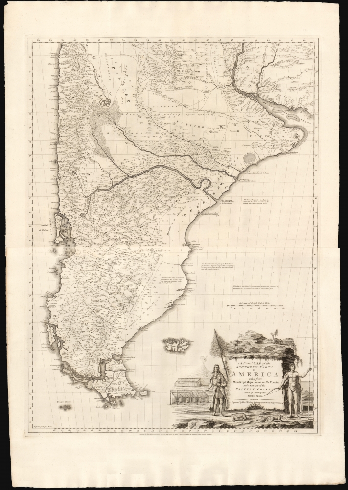
A New Map of the Southern Parts of America.
1772 (dated) 39 x 28.5 in (99.06 x 72.39 cm) 1 : 3168000
1772 (dated) 39 x 28.5 in (99.06 x 72.39 cm) 1 : 3168000
Description
This is a beautiful example of Thomas Kitchin and English Jesuit Missionary Thomas Falkner's huge 1772 map of South America below the Rio de la Plata. The map is the fruit of some forty years of exploration, providing the first glimpse of the interior regions of Patagonia based on firsthand experience.
A Closer Look
The map reaches from 30° to 56° South and spans from the Chilean coast to the mouth of the Rio de la Plata. It thus contains not only all of Patagonia and Tierra del Fuego, but most of western Uruguay on the east coast. Argentina is mapped as far north as the provinces of Entre Rios and Córdoba, while Chile on the Pacific Coast is mapped as far north as modern-day Los Vilos. The Falkland Islands appear as well.A New Map
Prior to the publication of this map, the best delineation of the southernmost part of America appeared on the 1748 map of South America by French geographer Jean Baptiste Bourguignon d'Anville (1697 - 1782), and in his discussion of the map in the text of Description of Patagonia it is explained that the east coast of the present work was based largely on d'Anville's work. Immediately upon leaving the coast, however, entirely new cartography. The earlier D'Anville cartography provides little detail of the interior. In addition, this map's treatment of the Falkland Islands was sufficiently advanced over Bougainville's 1772 'Carte des Isles Malouines' that the publisher felt the need to draw specific attention to it in the Advertisement. Falkner's reports can not always be relied upon - witness the profusion of endorheic lakes scattered among the broad mountain ranges south of the Rio Negro. But Falkner's divergence from D'Anville comes from experience. As he explains in the Description:All my own observations … oblige me to represent the country a great deal broader, from east to west, than it appears in Mr. D'Anville's map; which I am not able to reconcile to the relations of the Indians, nor to what I observed myself, with respect to the distances of places. Even in the Spanish country, he is I think mistaken, in making the distance between Cordova and Santa Fe forty leagues less than it is in reality…Certainly, compared with d'Anville, Falkner's map as interpreted by Kitchin provides a wealth of detail not present on earlier works, geographical, historical, and ethnographic. For example, a broad swath of the east coast of Patagonia is marked as 'dry uninhabited desart where the Indians bury their dead and sometimes come to seek for Salt.'
A Superb Engraving
Kitchin's realization of Falkner's map features also a superb cartouche, flanked by Patagonian natives, armadillos, anteaters, and some less well-defined critters. In the long tradition of European maps depicting indigenous peoples, their longhouses and lean-tos are also pictured.Publication History and Census
This map was engraved by Thomas Kitchin for publication in 1772, based on the report of Thomas Falkner. It was separately issued prior to the 1774 publication of the Description of Patagonia. While the map was clearly intended to be included in the work, we very often see examples of the book missing one or the other of the two sheets. We suspect the present example to be separately issued - it shows no evidence of having been folded or bound. While the Description is well represented in OCLC, we see only one example of the separate map so noted, in the Leventhal collection.CartographerS
Thomas Kitchin (August 4, 1718 – June 23, 1784) was a London based engraver, cartographer, and publisher. He was born in London to a hat-dyer of the same name. At 14, Kitchin apprenticed under Emanuel Bowen, under whom he mastered the art of engraving. He married Bowen daughter, Sarah Bowen, and later inherited much of his preceptor's prosperous business. Their son, Thomas Bowen Kitchin, also an engraver joined the family business, which thereafter published in Thomas Kitchin and Son. From 1858 or so Kitchin was the engraver to the Duke of York, and from about 1773 acquired the title, 'Royal Hydrographer to King George III.' He is responsible for numerous maps published in the The Star, Gentleman's Magazine, and London Magazine, as well as partnering with, at various times, with Thomas Jefferys, Emmanuel Bowen, Thomas Hinton, Issac Tayor, Andrew Dury, John Rocque, Louis de la Rochette, and Alexander Hogg, among others. Kitchin passed his business on to his son, Thomas Bowen Kitchin, who continued to republish many of his maps well after his death. Kitchin's apprentices included George Rollos, Bryant Lodge, Thomas Bowen Kitchin, Samuel Turner Sparrow, John Page, and Francis Vivares. More by this mapmaker...
Thomas Falkner (October 6, 1707 - January 30, 1784) was an English Jesuit missionary, explorer and physician. He was born in Manchester to an apothecary father. In about 1731 was ship's surgeon aboard Assiento, a slave vessel operatiing between Guinea and Buenos Aires, but his poor health led the ship's captain to leave him in Buenos Aires to recuperate. His convalescence was in the hands of the superior of the Jesuit College there, and upon regaining his health Falkner converted to Catholicism, and became a Jesuit priest. He spent forty years in the Patagonia region of South America, assisting in missions to the indigenous population there. As a result he became a primary explorer for the southern extremes of South America. His experiences informed the report of the region in The Description of Patagonia, written by William Combe and published in 1774 after Falkner's return to England in around 1772. The book provided an important record of the history and the flora and fauna of that part of the world. He is credited for recording the first fossil in Argentina (identified by him as a large armadillo, later to be identified as belonging to a glyptodon.) Falkner's reports also informed the map drawn by Thomas Kitchin for inclusion in The Description of Patagonia. Learn More...
Condition
Excellent. Two sheets, joined; few wormholes. Else a fine, unbound example with generous margins.
References
OCLC 505658237.