1935 Handy Pictorial Map of the Unites States, Paul Bunyan Folklore
PaulBunyanUnitedStates-handy-1935
Title
1935 (undated) 21 x 31 in (53.34 x 78.74 cm) 1 : 75000000
Description
A Closer Look
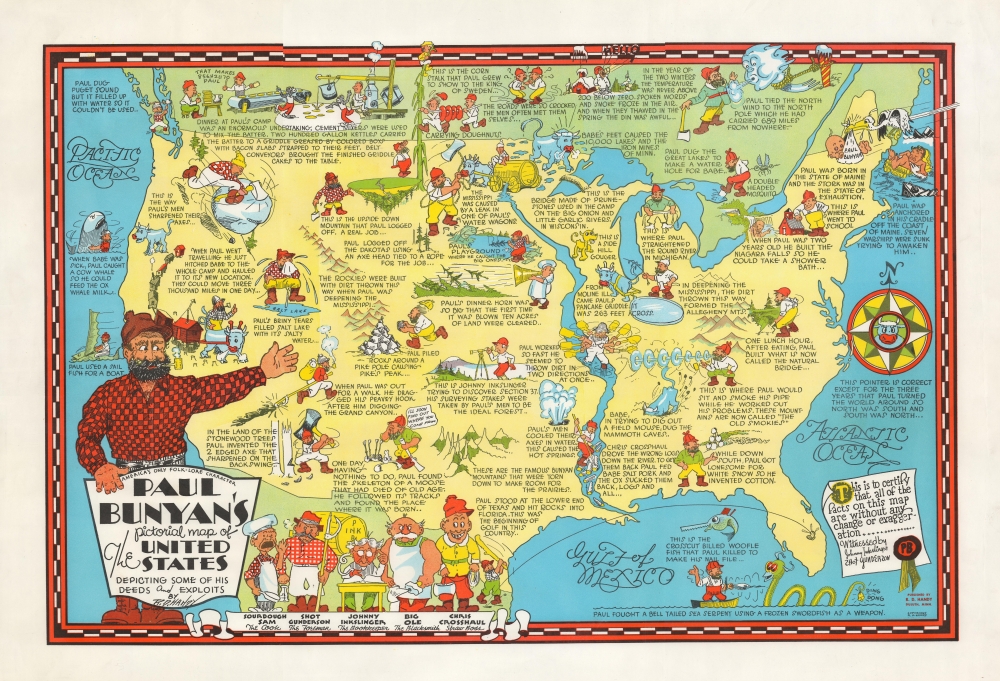
The map presents the United States and portions of Canada where Paul Bunyan mythology runs strong. Taking a tongue-in-cheek approach to the topic, Handy builds on the tall tales of Paul Bunyan to ascribe a whole series of unrelated events and features to the larger-than-life lumberjack and his trusty blue ox. For instance, the creation of the Mississippi River, Great Salt Lake, and Niagara Falls, to name a few, are said to have resulted from the actions of Paul Bunyan. Other characters associated with Paul Bunyan, including Johnny Inkslinger and Shot Gunderson, are also included.'America's Only Folk-Lore Character'
Handy's claim of the uniqueness of Paul Bunyan is, like the map itself, a bit over the top, but certainly, Paul Bunyan is among the most widely known American folk heroes and is especially important for Minnesota, neighboring states, and parts of Canada. Stories about the towering lumberjack appear to have begun circulating among more diminutive lumberjacks working along the U.S.-Canada border in the late 19th century. These stories were then embellished considerably and began to be printed for public consumption in the 1910s. By the time Handy produced this map, Paul Bunyan was a full-blown folk hero with demigod-like powers, a complete life story, and a host of superhuman accomplishments.Publication History and Census
This pictorial map was drawn by Raymond De Witt Handy c. 1935. It may have been meant to coincide with the publication of Handy's 1937 book Paul Bunyan and his Big Blue Ox (OCLC 3462715), but it does not appear to have been included with the book but separately issued. The map is noted among the holdings of nine institutions.Cartographer
Raymond De Witt Handy (August 21, 1877 - May 24, 1959), also as Raymond Dewitt Handy, was an illustrator active in Minnesota in the mid-20th century. Born in Minneapolis, Handy spent most of his adult life in Duluth. He is listed in city directories as a cartoonist as early as 1903 and was the long-time cartoonist for the Duluth News Tribune, having submitted cartoons published in the paper from 1906, if not earlier. A lifelong Minnesotan, Handy was deeply interested in the folklore and mythology of Paul Bunyan and published a heavily illustrated book on the topic in 1937. More by this mapmaker...


